Commission Implementing Regulation (EU)
2020/469
When terrain data sets are provided in accordance with point AIS.OR.355:
(a) terrain data sets shall contain the digital representation of the terrain surface in the form of continuous elevation values at all intersections of a defined grid, referenced to a common datum;
(b) a terrain grid shall be angular or linear and shall be of a regular or irregular shape;
(c) terrain data sets shall include spatial (position and elevation), thematic, and temporal aspects of the surface of the Earth, containing naturally occurring features, excluding obstacles;
(d) only one feature type, i.e. terrain, shall be provided;
(e) the following terrain feature attributes shall be recorded in the terrain data set:
(1) area of coverage;
(2) identification of the data originator er;
(3) data source identifier;
(4) acquisition method;
(5) post spacing;
(6) horizontal reference system;
(7) horizontal resolution;
(8) horizontal accuracy;
(9) horizontal confidence level;
(10) horizontal position;
(11) elevation;
(12) elevation reference;
(13) vertical reference system;
(14) vertical resolution;
(15) vertical accuracy;
(16) vertical confidence level;
(17) recorded surface;
(18) integrity;
(19) date and time stamp; and
(20) unit of measurement used;
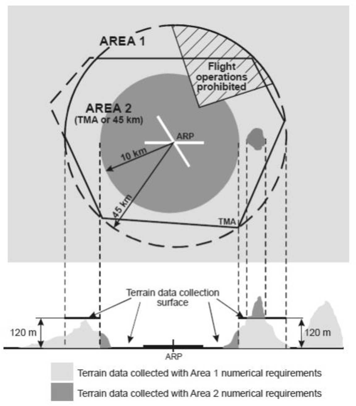
(f) Within the area covered by a 10-km radius from the ARP, terrain data shall comply with the Area 2 numerical requirements;
(g) in the area between 10 km and the TMA boundary or a 45-km radius, whichever is smaller, data on terrain that penetrates the horizontal plane 120 m above the lowest runway elevation shall comply with the Area-2 numerical requirements;
(h) in the area between 10 km and the TMA boundary or a 45-km radius, whichever is smaller, data on terrain that does not penetrate the horizontal plane 120 m above the lowest runway elevation shall comply with the Area-1 numerical requirements; and
(i) in those portions of Area 2 where flight operations are prohibited due to very high terrain or other local restrictions and/or regulations, terrain data shall comply with the Area-1 numerical requirements.
Terrain data collection surfaces – Area 1 and Area 2