Light
Dark
System
Log In
Loading...
Compare / EASA/
Incorporated Amendments
/
Compare & Highlight Differences
AIS.TR.355 Terrain data sets
Available versions for ERULES-1963177438-17748
Regulation (EU) 2020/469
found in: ATM/ANS Provision of Services (2017/373) (Feb 2023)
From
ATM/ANS Provision ... (Mar 2025)
ATM/ANS Provision ... (Feb 2023)
From section
To
ATM/ANS Provision ... (Mar 2025)
ATM/ANS Provision ... (Feb 2023)
To section
No visible text changes
0 removals
0 additions
View
Rich
Plain
Sync scrolling
Share
From
Show details
Hide details
To
Show details
Hide details
Version
Show side by side
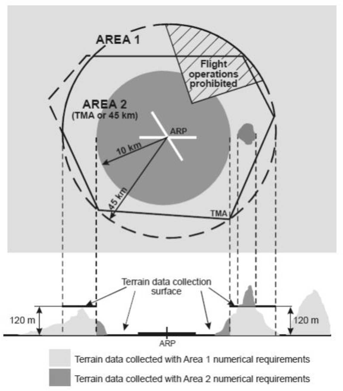
AIS.TR.355 Terrain data sets Commission Implementing Regulation (EU) 2020/469 When terrain data sets are provided in accordance with point [AIS.OR.355](#_DxCrossRefBm1726555999): (a) terrain data sets shall contain the digital representation of the terrain surface in the form of continuous elevation values at all intersections of a defined grid, referenced to a common datum; (b) a terrain grid shall be angular or linear and shall be of a regular or irregular shape; (c) terrain data sets shall include spatial (position and elevation), thematic, and temporal aspects of the surface of the Earth, containing naturally occurring features, excluding obstacles; (d) only one feature type, i.e. terrain, shall be provided; (e) the following terrain feature attributes shall be recorded in the terrain data set: (1) area of coverage; (2) identification of the data originator er; (3) data source identifier; (4) acquisition method; (5) post spacing; (6) horizontal reference system; (7) horizontal resolution; (8) horizontal accuracy; (9) horizontal confidence level; (10) horizontal position; (11) elevation; (12) elevation reference; (13) vertical reference system; (14) vertical resolution; (15) vertical accuracy; (16) vertical confidence level; (17) recorded surface; (18) integrity; (19) date and time stamp; and (20) unit of measurement used; (f) Within the area covered by a 10-km radius from the ARP, terrain data shall comply with the Area 2 numerical requirements; (g) in the area between 10 km and the TMA boundary or a 45-km radius, whichever is smaller, data on terrain that penetrates the horizontal plane 120 m above the lowest runway elevation shall comply with the Area-2 numerical requirements; (h) in the area between 10 km and the TMA boundary or a 45-km radius, whichever is smaller, data on terrain that does not penetrate the horizontal plane 120 m above the lowest runway elevation shall comply with the Area-1 numerical requirements; and (i) in those portions of Area 2 where flight operations are prohibited due to very high terrain or other local restrictions and/or regulations, terrain data shall comply with the Area-1 numerical requirements. Terrain data collection surfaces – Area 1 and Area 2 ![Aviation.Bot AI suggestion, not from EASA source: [Image caption skipped for debugging]](/static/files/file_gqs63YSDadR/image095.png)
AIS.TR.355 Terrain data sets Commission Implementing Regulation (EU) 2020/469 When terrain data sets are provided in accordance with point [AIS.OR.355](#_DxCrossRefBm647743180): (a) terrain data sets shall contain the digital representation of the terrain surface in the form of continuous elevation values at all intersections of a defined grid, referenced to a common datum; (b) a terrain grid shall be angular or linear and shall be of a regular or irregular shape; (c) terrain data sets shall include spatial (position and elevation), thematic, and temporal aspects of the surface of the Earth, containing naturally occurring features, excluding obstacles; (d) only one feature type, i.e. terrain, shall be provided; (e) the following terrain feature attributes shall be recorded in the terrain data set: (1) area of coverage; (2) identification of the data originator er; (3) data source identifier; (4) acquisition method; (5) post spacing; (6) horizontal reference system; (7) horizontal resolution; (8) horizontal accuracy; (9) horizontal confidence level; (10) horizontal position; (11) elevation; (12) elevation reference; (13) vertical reference system; (14) vertical resolution; (15) vertical accuracy; (16) vertical confidence level; (17) recorded surface; (18) integrity; (19) date and time stamp; and (20) unit of measurement used; (f) Within the area covered by a 10-km radius from the ARP, terrain data shall comply with the Area 2 numerical requirements; (g) in the area between 10 km and the TMA boundary or a 45-km radius, whichever is smaller, data on terrain that penetrates the horizontal plane 120 m above the lowest runway elevation shall comply with the Area-2 numerical requirements; (h) in the area between 10 km and the TMA boundary or a 45-km radius, whichever is smaller, data on terrain that does not penetrate the horizontal plane 120 m above the lowest runway elevation shall comply with the Area-1 numerical requirements; and (i) in those portions of Area 2 where flight operations are prohibited due to very high terrain or other local restrictions and/or regulations, terrain data shall comply with the Area-1 numerical requirements. Terrain data collection surfaces – Area 1 and Area 2