AMC1 UAS.SPEC.030(2) Application for an operational authorisation — EASA Form 208
ED Decision 2025/018/R
APPLICATION FORM FOR AN OPERATIONAL AUTHORISATION
The UAS operator should submit an application for an operational authorisation according to the following form. The application and all the documentation referred to or attached to the application should be stored for at least 2 years after the expiry of the related operational authorisation or submission of application in case of refusal. The UAS operator should ensure the protection of the stored data from unauthorised access, damage, alteration, and theft. The declaration may be complemented by the description of the procedures to ensure that all operations are in compliance with Regulation (EU) 2016/679 on the protection of natural persons with regard to the processing of personal data and on the free movement of such data, as required by point UAS.SPEC.050 (1)(a)(iv) of the UAS Regulation.
|
Application for an operational authorisation for the ‘specific’ category |
||||||||||||||||
|
|||||||||||||||||
Data protection: Personal data included in this application is processed by the competent authority pursuant to Regulation (EU) 2016/679 of the European Parliament and of the Council of 27 April 2016 on the protection of natural persons with regard to the processing of personal data and on the free movement of such data, and repealing Directive 95/46/EC (General Data Protection Regulation). Personal data will be processed for the purpose of the performance, management and follow-up of the application by the competent authority in accordance with Article 12 of Regulation (EU) 2019/947 of 24 May 2019 on the rules and procedures for the operation of unmanned aircraft. If the applicant requires further information concerning the processing of their personal data or exercising their rights (e.g. to access or rectify any inaccurate or incomplete data), they should refer to the point of contact of their competent authority. The applicant has the right to file a complaint regarding the processing of their personal data at any time to the national data protection supervisory authority. |
|||||||||||||||||
|
|||||||||||||||||
New application |
Amendment to operational authorisation NNN-OAT-xxxxx/yyy |
||||||||||||||||
1. UAS operator data |
|||||||||||||||||
1.1 UAS operator registration number |
|
||||||||||||||||
1.2 UAS operator name |
|
||||||||||||||||
1.3 Name of the accountable manager |
|
||||||||||||||||
1.3 Operational point of contact Name Telephone |
|
||||||||||||||||
2. Details of the UAS operation |
|||||||||||||||||
2.1 Expected date of start of the operation |
DD/MM/YYYY |
2.2 Expected end date |
DD/MM/YYYY |
||||||||||||||
2.3 Risk assessment reference and revision |
SORA edition date __ PDRA # __-__ edition date other _________ |
||||||||||||||||
2.4. Type of operation |
VLOS BVLOS |
||||||||||||||||
2.5 Transport of dangerous goods |
Yes No |
||||||||||||||||
2.6 Dropping material |
Yes No |
||||||||||||||||
2.7 What is the minimum RP:UA ratio allowed between the remote pilot (RP) and the UA that may be operated simultaneously? |
RP:UA ___:____ |
||||||||||||||||
2.8 Operations manual reference |
|
||||||||||||||||
2.9 Compliance matrix file reference |
|
||||||||||||||||
3. UAS data |
|||||||||||||||||
3.1 Design organsation name |
|
3.2 Model name |
|
||||||||||||||
3.3 Type of UAS |
Fixed wing Rotorcraft-helicopter Rotorcraft-gyroplane VTOL-capable aircraft (VCA) (including multirotors) Lighter than air / other |
3.4 Maximum UA characteristic dimensions |
_____ m |
||||||||||||||
3.5 Take-off mass |
_____ kg |
3.6 Maximum speed |
_____ m/s (_____ kt) |
||||||||||||||
3.7 Type of C2 link |
|
||||||||||||||||
3.8 Size of the adjacent ground area |
____ km |
||||||||||||||||
3.9 Is the UAS tethered during the operation? |
Yes No |
||||||||||||||||
3.10 Type of propulsion system |
Electric Combustion Hybrid, specify type: ______________________ Other, please specify: _____________________ |
||||||||||||||||
3.11 Serial number or, if applicable, UA registration mark |
|
||||||||||||||||
3.12 Type certificate (TC) or design verification report, if applicable |
|
||||||||||||||||
3.13 Number of the certificate of airworthiness (CofA), if applicable |
|
||||||||||||||||
3.14 Number of the noise certificate, if applicable |
|
||||||||||||||||
3.15 E-conspicuity system |
Direct remote ID Network remote ID SRD-860 In SRD-860 Out ADS-B In ADS-B Out Other________ |
||||||||||||||||
3.16 Green flashing light |
Yes No |
||||||||||||||||
I, the UAS operator, declare that: — the UAS operation complies with any applicable Union and national regulations related to privacy, data protection, liability, insurance, security, and environmental protection; — I have developed procedures to ensure that the intended UAS operation complies with the security requirements applicable to the area(s) of operation; — I have developed measures to protect against unlawful interference and unauthorised access; — I have developed procedures to ensure that all flights comply with Regulation (EU) 2016/679 on the protection of natural persons with regard to the processing of personal data and on the free movement of such data; — I have developed procedures for the remote pilot(s) to plan UAS operations in a manner that minimises nuisance, including noise- and other emissions-related nuisance, to people and animals; — I have records of: — all relevant qualifications and training courses completed by the remote pilot(s) and other personnel in charge of duties essential to the UAS operation and by maintenance staff, for at least 3 years after those persons have ceased employment with the organisation or have changed their position within the organisation; — the maintenance activities carried out on the UAS for a minimum of 3 years; — the information on UAS operations, including any unusual technical or operational occurrences and other data as required by the declaration or by the operational authorisation for a minimum of 3 years; — an up-to-date list of designated remote pilots-in-command for each flight, and if applicable, for each phase of flight; — an up-to-date list of maintenance staff employed to carry out maintenance activities; — the insurance coverage, if applicable, will be in place at the expected date of start of the UAS operation |
|||||||||||||||||
Section 4 – Specific operations risk assessment (SORA) |
|||||||||||||||||
Step #1 — Documentation of the proposed operation |
|||||||||||||||||
Step #1.1 Description of proposed locations |
— If location-specific: Give reference to the file: ___________________________________
— If location-independent: (generic authorisation) Give reference to the file as example of a location: ___________________________________ |
||||||||||||||||
Step #1.2 Short description of the proposed operation
|
|||||||||||||||||
Step #1.3 Dimensions of the operational volume and the adjacent volume (Rounded up to first decimal place) |
Maximum height of the flight geography Maximum height of the contingency volume Width of the contingency volume Width of the ground risk buffer Width of the adjacent volume |
HFGmax
HCVmax
SCVmax SGRBmax
|
________
m
________
m
________
m
________
m ________ m |
||||||||||||||
Step #2 — UAS intrinsic ground risk class (iGRC) |
|||||||||||||||||
Step #2.1 Type of operational areas or maximum population density on the ground (including flight geography, contingency volume and ground risk buffer) |
controlled ground area people/km2 sparsely populated area up to 5 up to 50 up to 500 populated area up to 5 000 up to 50 000 more than 50 000 assemblies of people no limit
|
||||||||||||||||
Step #2.2 Specify the intrinsic ground risk class (iGRC) |
|
||||||||||||||||
Step #2.3 Remarks/Reasoning for Step #2 (optional)
|
|||||||||||||||||
Step #3 — Final ground risk class (GRC) determination (optional) |
|||||||||||||||||
Step #3.1 Specify the ground risk mitigations applied and the level of robustness (if applicable) |
M1(A) Strategic mitigation — sheltering |
||||||||||||||||
☐None |
☐Low |
☐Medium |
|
||||||||||||||
M1(B) Strategic mitigation — operational restrictions |
|||||||||||||||||
☐None |
|
☐Medium |
☐High |
||||||||||||||
M1(C) Tactical mitigation — ground observation |
|||||||||||||||||
☐None |
☐Low |
|
|
||||||||||||||
M2 Effects of UA impact dynamics are reduced |
|||||||||||||||||
☐None |
|
☐Medium |
☐High |
||||||||||||||
Step #3.2 Specify the final ground risk class (GRC) |
|
||||||||||||||||
Step #3.2 Remarks/Reasoning for Step #3 (optional)
|
|||||||||||||||||
Step #4 — Initial air risk class (ARC) |
|||||||||||||||||
Step #4.1 Classification of the airspace where the operation is intended to be conducted (multiple answers possible) |
☐A |
☐B |
☐C |
☐D |
☐E |
☐F |
☐G |
||||||||||
☐Restricted area |
☐Danger area |
||||||||||||||||
☐TMZ ☐RMZ ☐ATZ ☐CTR ☐CTA ☐FIZ |
|||||||||||||||||
Step 4.2 Specify the initial air risk class (ARC) of the operational volume |
☐ARC-a ☐ARC-b ☐ARC-c ☐ARC-d |
||||||||||||||||
Step #4.3 Remarks/Reasoning for choosing the ARC in Step #4
|
|||||||||||||||||
Step #5 — Strategic air risk mitigations and final air risk class (ARC) |
|||||||||||||||||
Step #5.1 Specify the strategic mitigations of the air risk class, if applied |
☐No |
☐ VLOS ☐BVLOS with AOs ☐ Operational restrictions ☐ Common rules and structures |
|||||||||||||||
Step #5.2 Residual air risk class (after strategic mitigation) |
☐ARC-a ☐ARC-b ☐ARC-c ☐ARC-d |
||||||||||||||||
Step #5.3 Remarks/Reasoning for Step #5 (not needed if no mitigation applied)
|
|||||||||||||||||
Step #6 — Tactical mitigation performance requirements (TMPRs) and robustness level |
|||||||||||||||||
Step #6 Tactical mitigation performance requirements (TMPRs) |
☐ No requirement (VLOS / BVLOS with AOs) ☐BVLOS ☐No requirement (ARC-a) ☐Low (ARC-b) ☐Medium (ARC-c) ☐High (ARC-d) |
||||||||||||||||
Step #6.1 Remarks/Reasoning for Step #6 (optional)
|
|||||||||||||||||
Step #7 — SAIL determination |
|||||||||||||||||
Step #7.1 Specific assurance and integrity level (SAIL) |
☐SAIL I ☐SAIL II ☐SAIL III ☐SAIL IV ☐SAIL V ☐SAIL VI |
||||||||||||||||
Step #8 — Determination of containment requirements |
|||||||||||||||||
Step #8.1 Containment |
☐Low ☐Medium ☐High ☐Tethered |
||||||||||||||||
Step #8.2 Assembly of people within 1 km of the operational volume? |
☐No ☐Yes |
||||||||||||||||
Step #8.2 Remarks/Reasoning for Step #8 (optional)
|
|||||||||||||||||
Step #9 — Identification of operational safety objectives (OSOs) |
|||||||||||||||||
Step #9.1 Operational safety objectives |
|
||||||||||||||||
5. Remarks |
|||||||||||||||||
|
|||||||||||||||||
Date DD/MM/YYYY |
Signature and stamp |
||||||||||||||||

EASA Form 208
Instructions for filling in the application form
If the application relates to an amendment to an existing operational authorisation, indicate the number of the operational authorisation and fill out in red the fields that are amended compared to the last operational authorisation.
Section 1
1.1 UAS operator registration number in accordance with Article 14 of the UAS Regulation.
1.2 UAS operator’s name as declared during the registration process.
1.3 Contact details of the person responsible for the operation, in charge to answer possible operational questions raised by the competent authority.
2.2 Date on which the UAS operator expects to end the operation. The UAS operator may ask for an unlimited duration; in this case, indicate ‘Unlimited’.
2.3 Select one of the three options. If the SORA is used, indicate the edition date as defined in AMC1 Article 11. In case a PDRA is used, indicate the number and its edition date as defined in the applicable AMC to Article 11. In case a risk assessment methodology is used other than the SORA, provide its reference. In this last case, the UAS operator should demonstrate that the methodology complies with Article 11 of the UAS Regulation. In case a PDRA is used, then section 4 of this form is not required to be completed.
2.7 If the UAS flight manual provided by the UAS designer indicates that it is designed with a level of automation that reduces the remote pilot’s workload allowing one remote pilot (RP) to control multiple UA simultaneously, then specify the number of UA that one remote pilot is permitted to control (e.g. in case one RP is able to control simultaneously five UA, indicate RP:UA 1:5). This number should not exceed the limit defined in the UAS flight manual. Additionally, the UAS operator may decide to have a pool of remote pilots controlling multiple UA simultaneously. In this case, clear procedures should be developed to define who is the pilot-in-command, responsible during each phase of the flight (e.g. in case three RPs are permitted to control simultaneously ten UA, indicate RP:UA 3:10).
2.8 Indicate the OM’s identification and revision number.
2.9 Indicate the compliance matrix file identification and revision number (e.g. the compliance matrix defined in Chapter A.4 of Annex A to AMC1 Article 11 (SORA). This document should be attached to the application.
Section 3
This section may be replicated for all authorised UAS models to be used under this operational authorisation.
3.2 Model of the UAS as defined by the design organisation in the UAS flight manual.
3.3 Fixed-wing UA includes configurations such as aeroplanes, kites, gliders, etc.).
Rotorcraft-helicopter UA includes all vertical-lift configurations having up to 2 rotors.
Rotorcraft-gyroplane UA is a special configuration with unpowered rotor.
VTOL-capable aircraft (VCA) UA includes vertical-lift configurations with 3 or more rotors and fixed-wing UA capable of vertically taking off and landing.
Lighter-than-air configurations include configurations such as airships, hot-air balloons, etc.
3.4 Indicate the maximum dimensions of the UA in metres (refer to definition I.141 ‘UA characteristic dimension’ in Annex I of AMC1 Article 11 (SORA)).
3.5 Indicate the maximum value of the UA take-off mass (TOM), expressed in kg, at which the UA may be operated. All flights should be conducted without exceeding the specified TOM. The TOM may be different from (however, not exceeding) the MTOM defined by the UAS design organisation in the UAS flight manual.
3.6 Maximum operational airspeed, expressed in m/s and kt in parentheses, that the remote pilot will not exceed during the operation. This should always be lower than the maximum defined in the UAS flight manual.
3.7 Indicate the type of C2 link to be used during the operation (e.g. radio link, LTE/5G, satellite, etc.).
3.8 indicate the size in km to be considered for the adjacent ground area starting from the limits of the ground risk buffer, using the instructions defined in Section S.4.8.4 of AMC1 Article 11 (SORA).
3.11 This field is mandatory if the UA is registered according to Article 14(7) of Implementing Regulation (EU) 2019/947. If the UA is not registered, the NAA may indicate the unique serial number (SN) of the UA defined by the design organisation according to standard ANSI/CTA‑2063‑A‑2019, Small Unmanned Aerial Systems Serial Numbers, 2019. In case of privately built UAS or UAS not equipped with a unique SN, insert the unique SN of the remote identification system. For UAS operations classified in SAIL V or higher, the serial numbers of all UAS should be provided and any change to them would require the competent authority’s prior approval. For UAS operations classified up to SAIL IV, a change to the serial number does not require a prior approval from the competent authority.
3.12 Include the EASA TC number, or the UAS design verification report (DVR) number issued by EASA, if applicable.
3.13 If a UAS with an EASA TC is required by the competent authority, the UAS should have a certificate of airworthiness (CofA).
3.14 If a UAS with an EASA TC is required by the competent authority, the UAS should have a noise certificate.
3.15 Multiple options are possible. Direct remote ID developed according to EN 4709-002.
In order to compile Section 4, please refer to AMC1 Article 11 (SORA).
Section 4
Step #1.1:
The identification of the location(s) should contain the full operational volume and ground risk buffer (the red line in Figure 1; refer to Annex A to AMC1 Article 11 for guidance and examples on the calculation of the operational volume and ground risk buffer). Depending on the initial ground and air risk classification determined using the SORA process and on the application of mitigations, the location(s) may be ‘generic’ or ‘precise’ (refer to GM2 UAS.SPEC.030(2)).
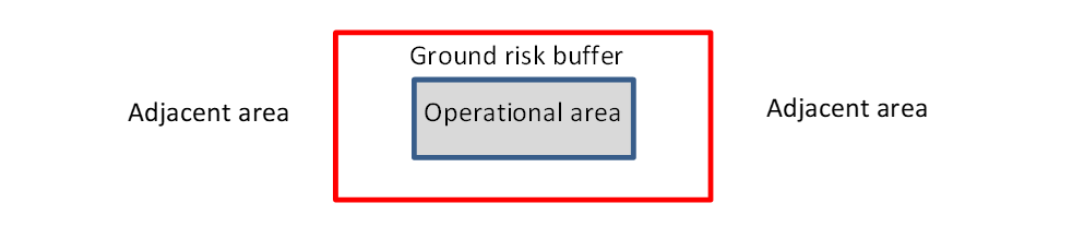
Figure 1 — Operational area and ground risk buffer
— Please, refer to GM2 UAS.SPEC.030(2) for guidance on the conditions to apply for ‘generic’ versus ‘precise’ locations.
— If location-specific: please, provide a list with the geo-coordinates for each location including the operational volume (flight geography and contingency volume), the ground risk buffer and the air risk buffer (if available) as a separate file using either ‘.txt’, ‘.kmz’ or ‘.kml’.
— If location-independent: please, provide a reference to the documented process for the determination of volumes and buffers and the assessment of the local conditions and their compliance limitations. An example of a geographical file (e.g. ‘.kmz’ or ‘.kml’) may be provided to show a typical operational volume, ground risk buffer and the air risk buffer (if available).
Step #1.2: Insert, for example, transport, inspection, filming, testing, etc.
Step #1.3: Please, provide a list with this information if location-specific with multiple locations.
Step #4.1: For information on the airspace classification, refer to Article 2 and to points SERA.6001 and SERA.6005 of Regulation (EU) No 923/2012.
Step #9.1: List the OSOs and the level of robustness you intend to comply with. The level of robustness should as a minimum reflect the one defined in Table 14 of Section S.4.9.3 of AMC1 Article 11 considering the SAIL listed in point ‘Step #7.1’ of this form.
SECTION 5 Free-text field for the addition of any relevant remark.
Note: The signature and stamp may be provided in electronic form.