Light
Dark
System
Log In
Loading...
Compare / EASA/
Incorporated Amendments
/
Compare & Highlight Differences
Annex A to AMC1 Article 11
Available versions for ERULES-1963177438-24087
ED Decision 2025/018/R
found in: Unmanned Aircraft Systems (Jun 2026)
Version
Unmanned Aircraft ... (Jun 2026)
Section
Share
Version
Show details
Hide details
Version
##### Annex A to AMC1 Article 11 *ED Decision 2025/018/R* **GUIDELINES ON COLLECTING AND PRESENTING INFORMATION ON SYSTEMS AND OPERATIONS REGARDING UAS OPERATIONS CONDUCTED IN THE ‘SPECIFIC’ CATEGORY** The purpose of this Annex is to provide guidance to UAS operators for collecting and presenting evidence and data required when compiling an application to obtain operational authorisation for UAS operations in the ‘specific’ category. This document does not replace civil regulations but provides recommendations and guidance as to how UAS operators can comply with those regulations using the SORA process. This document is composed of the following five chapters: — **A.1: Key principles for completing the application documents for UAS operations to be conducted in the ‘specific’ category** It explains the different documents and how to use them to compile an application. — **A.2: SORA risk assessment template** It is intended to support UAS operators in compiling all the information necessary to perform a risk assessment. — **A.3: Structure of the operations manual** It provides an operations manual model structure for UAS operators to follow in order to present their operations manual in an appropriate manner. — **A.4: Compliance matrix** It provides a template for UAS operators on how to present the reference between the SORA-driven requirements and the operations manual. — **A.5: How to document and present a flight area** It contains guidance for UAS operators on how to create and include a flight area into the operations manual. **A.1 Key principles for completing the application documents for UAS operations to be conducted in the ‘specific’ category** **How does an application generally work?** The operations manual serves as the basis for an operational authorisation for UAS operations to be conducted in the ‘specific’ category. When the competent authority issues the operational authorisation, it accepts the related operations manual. **General workflow** Before starting collecting information and describing procedures, the UAS operator should outline a preliminary operational concept (refer to Section S.4.1 of this AMC). This preliminary operational concept ensures that the UAS operator can effectively explore all available options, and select the most suitable approach for its specific needs. Key considerations for this initial plan include the following: — the intended flight location(s); — the maximum operational flight altitude and speed; — the flight mode: either VLOS or BVLOS with or without AOs; — the type of UAS to be used; — environmental limitations (time of day, weather). In the next step, the UAS operator assesses the risk for the operation and develops a high-level overview of the SORA requirements. For this, the UAS operator should apply the requirements of Section A.2 and follow each step of the SORA process. When SORA phase 1 (see Figure A.1) is completed, it is considered best practice for a UAS operator to liaise with the competent authority before moving to the data collection and procedure description (refer to Section S.3.3 of this AMC) to share its preliminary operational information and initial risk assessment. The competent authority and the UAS operator evaluate the alignment of the risk assessment with the operational information and check the correct application of the SORA steps. The competent authority may provide feedback to the UAS operator on its expectations on how to achieve an operational authorisation considering the resulting SAIL. Once the risk assessment (i.e. the outcome of SORA Phase 1) has been validated and the UAS operator has secured confirmation from the competent authority, the next step involves identifying the specific requirements that arise from the risk assessment (i.e. conduct SORA phase 2 and develop the evidence in support of compliance with the applicable OSOs, mitigations and containment). Following this identification, the UAS operator should then collect the relevant evidence and information, as well as describe the procedures that will be implemented. The UAS operator should ensure that all integrity and corresponding assurance requirements are met. These can be found in Annexes [B](#_DxCrossRefBm1295819073) to [E](#_DxCrossRefBm1295819071) to this AMC. It is recommended to use the operations manual structure provided in Chapter A.3 for this purpose. The UAS operator should use the template provided in Chapter A.4 (Compliance matrix) once all procedures are described and evidence is collected. This is done by providing the corresponding reference to the integrity and/or assurance evidence for each requirement. This document serves as a checklist for the UAS operator to review before submitting an application. The competent authority may use this document as a reference to assist the review process. The competent authority reviews the application in accordance with the requirements arising from the risk assessment and the respective SAIL. In this process, the implementation of all technical and operational requirements is checked based on the descriptions in the operations manual, or other associated documents as required. The competent authority has the option to request the UAS operator to revise the documents and resubmit them, or ask for additional supporting documentation. For the UAS operator to address the additional requests effectively, the competent authority may also provide guidance on how the UAS operator can proceed to close any outstanding issues. Figure A.1 graphically depicts the process described above and thus serves as an additional illustration of the general workflow. 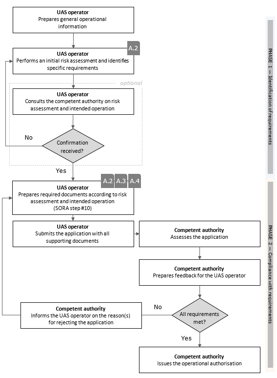 **Figure A.1 — Recommended level of detail and use of supporting documents and references** The operations manual and its associated annexes should enable the UAS operator to describe how to conduct the operation safely for the benefit of its staff. It should include the identification of the flight area, all normal, contingency and emergency procedures and additional information derived by the compliance with the required OSOs, mitigations and containment requirements. Supporting documents serving as evidence for the compliance with the required OSOs, mitigations and containment requirements may be referenced in the operations manual and can be linked in the compliance matrix (see Section A4) and be included in a separate document. Evidence developed in support of requirements having a low level of robustness (related to the OSOs, based on the SAIL of the operation or to the level of mitigation and or to the containment chosen by the UAS operator) may be kept internal to the UAS operator’s organisation. The same applies in case the level of robustness of the requirements is medium and the UAS operators decided to use AMC published by EASA. The competent authority may require those evidence during the oversight audit or anytime. In case the level of robustness of the requirements is high or it is medium and the UAS operators decided not to use AMC published by EASA, then the evidence should be provided with the application of the operational authorisation. The competent authority may request further documents if considered necessary by the competent for the given operation. **Document set-up for additional flight areas, UAS or UAS operations** When a UAS operator seeks to expand its approved operations manual(s) to include a new flight area, a UAS or a UAS operation, the primary question is whether the underlying risk assessment covers these additions. If it does, the new information can be incorporated into existing parts (see Chapter A.3 of this Annex — Part A to T) of the operations manual(s). Otherwise, it is considered best practice to establish new parts for such information. When dealing with complex UAS operations (e.g. multiple types of UAS operations and multiple UAS employed), the UAS operator may find it useful to use a different structure of the operations manual compared to that proposed by this Annex. In this case, it is recommended to discuss the proposed manual’s structure with the competent authority to ensure it meets both national and industry standards. Operation-specific details should typically be organised into separate parts for clarity during approval and ease of use. Conversely, general or related information can be consolidated into a common segment. An example would be adding an additional UAS with the same characteristic dimensions, but a different set of procedures. This could be added to existing Part B; for illustration purposes, see Figure A.2. 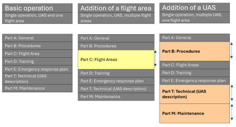 **Figure A.2 — Common scenarios and how they may impact the operations manual** **A.2 SORA risk assessment template** **Introduction** This chapter serves as a guide to assist UAS operators in compiling all the necessary information for conducting a risk assessment. UAS operators should submit an application for an operational authorisation using the form provided in [AMC1 UAS.SPEC.030(2)](#_DxCrossRefBm1295819087). By providing this questionnaire-style template for documenting the risk assessment, UAS operators are encouraged to focus on the essential information required and to avoid unnecessary lengthy explanations about their operational procedures. The ‘remarks’ section is optional and is designed for UAS operators to provide additional information when needed, helping to prevent misunderstandings. At this stage, no evidence is required as the requirements are determined by the risk analysis process. Once the application form is completed, both the UAS operator and the competent authority will have all the necessary information to complete Phase 1 assessment (for reference, see Figure A.1). Note that for Phase 1 the fields 2.9 (OM references) and 2.10 (compliance evidence file reference) of the application form ([AMC1 UAS.SPEC.030(2)](#_DxCrossRefBm1295819087)) may not be filled in yet. In situations involving the use of multiple UA or flight areas with varying ground or air risk classes, it is advisable to consult with the competent authority. This practice helps ensuring alignment with competent authority expectations and adherence to national standards. In certain cases, it may be possible to include multiple UA or flight areas into one form. Evidence should not be included in the application form. Instead, it should be incorporated into the operations manual (Chapter A.3 ‘Structure of the operations manual’) and referenced in the CSP (Chapter A.4 ‘Compliance matrix’). **A.3 Structure of the operations manual** **Introduction** The intention of this chapter is to provide a standardised framework for documenting essential information that relates to a specific operation. It serves only as an example structure for UAS operators to create a comprehensive document that outlines the procedures and relevant details necessary for the safe and efficient execution of a UAS operation[[50]](#_ftn50). In the example structure, the operations manual is divided into logical subject parts, which in turn offer a structure as regards where to include specific topics that are crucial for creating a standardised manual for the safe operation of UAS. While the structure is not inherently mandatory, the topics it contains should be incorporated into the operations manual as needed for the specific operation(s) to provide the relevant information and evidence required for the safe operation of UAS. It is advisable to adhere to the provided structure, as it aligns with the expectations and practices of most competent authorities. An example of an operations manual may be found on the EASA website[[51]](#_ftn51). In general, any information that does not have direct operational relevance to the UAS operator or its staff should be placed in the relevant annex to ensure the document remains concise and reader-friendly. The main purpose of this structure is the following: 1. **Standardisation:** It ensures that all critical aspects of the UAS operation are documented consistently, following applicable industry standards and regulations, and best practices. 2. **Compliance:** It helps operators meet regulatory requirements by specifying the information and procedures needed to obtain necessary approvals and certification. 3. **Clarity:** It provides a clear and organised structure for conveying operational procedures, safety protocols and other essential information, thus reducing the risk of misunderstandings and errors. 4. **Safety:** It emphasises safety measures, emergency procedures and risk-mitigation strategies to enhance the overall safety during the operation. 5. **Efficiency:** It streamlines the process of creating an operations manual by providing predefined sections and guidelines, helping UAS operators save time and effort. 6. **Consistency:** It ensures that all UAS operators that are involved in the operation of the same UAS type follow the same documented procedures, promoting uniformity and reducing the potential for confusion. 7. **Reference:** It serves as a valuable reference document for UAS operators, remote crew members, competent authorities and other stakeholders involved in, or overseeing, the UAS operation. 8. **Documentation:** It aids in the systematic recording of operational details, making it easier to track changes, updates, and compliance with evolving regulatory requirements. **Recommended structure for the operations manual** Cover page Document control Other applicable documents Purpose and scope of this document List of contents List of definitions and abbreviations 1 Part A — General Part 1.1 Opening statement 1.2 Security and privacy statement 1.3 Environmental statement 1.4 The operating organisation 1.4.1 Structure / organisation chart 1.4.2 Duties and responsibilities of the personal 1.5 Change management 1.6 Retention periods 1.7 Document control 1.8 Requirements and qualifications for personnel 1.8.1 Remote pilot 1.8.2 Maintenance personnel 1.8.3 Ground staff 1.8.4 Training, examination and supervision personnel 1.9 Crew member is ‘fit for the operation’ 1.9.1 Preventive health care 1.9.2 Duty hours and rest periods 2 Procedures (Part B) 2.1 Multi-crew coordination 2.2 Flight planning 2.2.1 Use of up-to-date information 2.2.2 Geographical zones 2.3 External services and systems 2.3.1 Services 2.3.2 Systems 2.4 Procedures for obtaining information about and evaluating weather conditions 2.5 Procedures for responding to unexpected adverse weather conditions 2.6 Procedures for tactical mitigation performance requirements (TMPRs) 2.7 Occurrence reporting 2.7.1 What must be reported? 2.7.2 Who must report? 2.7.3 What must be observed after reporting? 2.8 Procedures specifically for UAS 1 2.8.1 Normal procedures 2.8.2 Contingency procedures 2.8.3 Emergency procedures 2.9 Procedures specifically for UAS 2 2.9.1 Normal procedures 2.9.2 Contingency procedures 2.9.3 Emergency procedures 3 Part C — Flight areas 3.1 General operational limitations 3.1.1 Environmental conditions 3.1.2 Technical operational limitations 3.2 Flight area 1 3.2.1 Description 3.2.2 Calculation of the contingency volume (CV) / ground risk buffer (GRB) 3.2.3 Specific procedures for flight area 1 3.2.4 Emergency response plan (ERP) — Local information 3.3 Flight area 2 3.3.1 Description 3.3.2 Calculation of the contingency volume (CV) / ground risk buffer (GRB) 3.3.3 Specific procedures for flight are 2 3.3.4 Emergency response plan (ERP) — Local information 3.4 Flight area 3 3.4.1 Description 3.4.2 Calculation of the contingency volume (CV) / ground risk buffer (GRB) 3.4.3 Specific procedures for flight area 3 3.4.4 Emergency response plan (ERP) — Local information 4 Part D — Training 5 Part E — Emergency response plan (ERP) 5.1 General 5.2 Creation of the ERP 5.3 ERP template 5.4 Preparation and briefing 5.5 Reporting procedures and obligations after an emergency 6 Part T — Technical part of the UAS 6.1 UAS 1 [Model/Type] 6.1.1 Description 6.1.2 Image/graphic 6.1.3 C3 link 6.1.4 Parachute (M2) 6.1.5 TMPRs 6.1.6 Containment 6.1.7 Human–machine interface (HMI) 6.1.8 Payload 6.1.9 Automatic protection of the flight envelope 6.1.10 Designed and qualified to operate in adverse environmental conditions 6.2 UAS 2 [Model/Type] 6.2.1 Description 6.2.2 Image/graphic 6.2.3 C3 link 6.2.4 Parachute (M2) 6.2.5 TMPRs 6.2.6 Containment 6.2.7 Human–machine interface (HMI) 6.2.8 Payload 6.2.9 Automatic protection of the flight envelope 6.2.10 Designed and qualified to operate in adverse environmental conditions 7 Part M — Maintenance 7.1 General 7.2 Software updates 7.3 Maintenance of UAS 1 [Model/Type] 7.4 Maintenance of UAS 2 [Model/Type] 8 Annex 8.1 Evidence 8.1.1 Organisational evidence 8.1.1.1 Organisational operating certificate 8.1.1.2 Maintenance programme / organisation certificate 8.1.2 Operational evidence 8.1.2.1 Operational agreements (e.g. with ATC) 8.1.2.2 M1 8.1.2.3 Flight tests 8.1.2.4 Performance of external services and systems 8.1.3 Technical evidence 8.1.3.1 Design (DVR, TC) 8.1.3.2 M2 8.1.3.3 Manufacturer competence 8.2 Printed forms 8.2.1 List of maintenance personnel 8.2.2 List of personnel authorised to conduct pre-flight and post-flight inspections 8.2.3 List of the training/experience level of personnel 8.2.4 List of authorised remote pilots 8.2.5 List of personnel trained in the emergency response plan (ERP) 8.2.6 Operator flight logbook 8.2.7 Technical logbook 8.3 Checklists 8.3.1 ERP template 8.3.2 Pre-flight inspection — Checklist 8.3.3 Post-flight inspection — Checklist 8.4 Manuals 8.4.1 Maintenance manual for UAS 1 8.4.2 Maintenance manual for UAS 1 **Reference table for the requirements** **specified in the annexes to AMC1 (SORA)** The following table offers a comprehensive overview of the suitable locations within the operations manual where the requirements specified in the annexes to AMC1 (SORA) can be sensibly incorporated. <table cellpadding="5" cellspacing="0"> <col/> <col/> <col/> <col/> <tr> <td bgcolor="#d9d9d9"><p align="left"> <b>OSOs ↓</b></p> </td> <td bgcolor="#d9d9d9"><p align="center"> <b>Integrity (I) /</b></p> <p align="center"><b>Assurance (A)</b></p> </td> <td bgcolor="#d9d9d9"><p align="center"> <b>Criterion</b></p> </td> <td bgcolor="#d9d9d9"><p align="center"> <b>OM</b></p> </td> </tr> <tr> <td bgcolor="#dbe5f1" rowspan="2"><p align="left"> <b>OSO #01</b></p> </td> <td bgcolor="#ffffff"><p align="center"> <b>I</b></p> </td> <td bgcolor="#ffffff"><p align="center"> —</p> </td> <td bgcolor="#ffffff"><p align="center"> <b>Part A</b></p> <p align="center"><b>Part D</b></p> </td> </tr> <tr> <td bgcolor="#ffffff"><p align="center"> <b>A</b></p> </td> <td bgcolor="#ffffff"><p align="center"> —</p> </td> <td bgcolor="#ffffff"><p align="center"> <b>Annex 8.1.1.1</b></p> </td> </tr> <tr> <td bgcolor="#dbe5f1" rowspan="2"><p align="left"> <b>OSO #02</b></p> </td> <td bgcolor="#ffffff"><p align="center"> <b>I</b></p> </td> <td bgcolor="#ffffff"><p align="center"> —</p> </td> <td bgcolor="#ffffff"><p align="center"> <b>Part T</b></p> </td> </tr> <tr> <td bgcolor="#ffffff"><p align="center"> <b>A</b></p> </td> <td bgcolor="#ffffff"><p align="center"> —</p> </td> <td bgcolor="#ffffff"><p align="center"> <b>Annex 8.1.3.3</b></p> </td> </tr> <tr> <td bgcolor="#dbe5f1" rowspan="4"><p align="left"> <b>OSO #03</b></p> </td> <td bgcolor="#ffffff"><p align="center"> <b>I</b></p> </td> <td bgcolor="#ffffff"><p align="center"> —</p> </td> <td bgcolor="#ffffff"><p align="center"> <b>Part M Chapter 7.1</b></p> <p align="center"><b>Annex 8.1.1.2</b></p> </td> </tr> <tr> <td bgcolor="#ffffff" rowspan="3"><p align="center"> <b>A</b></p> </td> <td bgcolor="#ffffff"><p align="center"> <b>#1</b></p> </td> <td bgcolor="#ffffff"><p align="center"> <b>Part A Chapter 1.7</b></p> <p align="center"><b>Annex 8.1.1.2</b></p> </td> </tr> <tr> <td bgcolor="#ffffff"><p align="center"> <b>#2</b></p> </td> <td bgcolor="#ffffff"><p align="center"> <b>Part A Chapter 1.7</b></p> <p align="center"><b>Annex 8.1.1.2</b></p> </td> </tr> <tr> <td bgcolor="#ffffff"><p align="center"> <b>#3</b></p> </td> <td bgcolor="#ffffff"><p align="center"> <b>Part A Chapter 1.6</b></p> <p align="center"> <b>Part A Chapter 1.7</b></p> <p align="center"><b>Annex 8.1.1.2</b></p> </td> </tr> <tr> <td bgcolor="#dbe5f1" rowspan="2"><p align="left"> <b>OSO #04</b></p> </td> <td bgcolor="#ffffff"><p align="center"> <b>I</b></p> </td> <td bgcolor="#ffffff"><p align="center"> —</p> </td> <td bgcolor="#ffffff"><p align="center"> <b>Part T</b></p> </td> </tr> <tr> <td bgcolor="#ffffff"><p align="center"> <b>A</b></p> </td> <td bgcolor="#ffffff"><p align="center"> —</p> </td> <td bgcolor="#ffffff"><p align="center"> <b>Annex 8.1.3.1</b></p> </td> </tr> <tr> <td bgcolor="#dbe5f1" rowspan="2"><p align="left"> <b>OSO #05</b></p> </td> <td bgcolor="#ffffff"><p align="center"> <b>I</b></p> </td> <td bgcolor="#ffffff"><p align="center"> —</p> </td> <td bgcolor="#ffffff"><p align="center"> <b>Part T</b></p> </td> </tr> <tr> <td bgcolor="#ffffff"><p align="center"> <b>A</b></p> </td> <td bgcolor="#ffffff"><p align="center"> —</p> </td> <td bgcolor="#ffffff"><p align="center"> <b>Annex 8.1.3.1</b></p> </td> </tr> <tr> <td bgcolor="#dbe5f1" rowspan="2"><p align="left"> <b>OSO #06</b></p> </td> <td bgcolor="#ffffff"><p align="center"> <b>I</b></p> </td> <td bgcolor="#ffffff"><p align="center"> —</p> </td> <td bgcolor="#ffffff"><p align="center"> <b>Part T Chapter 6.1.3</b></p> </td> </tr> <tr> <td bgcolor="#ffffff"><p align="center"> <b>A</b></p> </td> <td bgcolor="#ffffff"><p align="center"> —</p> </td> <td bgcolor="#ffffff"><p align="center"> <b>Annex 8.1.3.1</b></p> </td> </tr> <tr> <td bgcolor="#dbe5f1" rowspan="3"><p align="left"> <b>OSO #07</b></p> </td> <td bgcolor="#ffffff"><p align="center"> <b>I</b></p> </td> <td bgcolor="#ffffff"><p align="center"> —</p> </td> <td bgcolor="#ffffff"><p align="center"> <b>Part B Chapter 2.8.1</b></p> <p align="center"> <b>Part D</b></p> <p align="center"><b>Annex 8.2.6</b></p> </td> </tr> <tr> <td bgcolor="#ffffff" rowspan="2"><p align="center"> <b>A</b></p> </td> <td bgcolor="#ffffff"><p align="center"> <b>#1</b></p> </td> <td bgcolor="#ffffff"><p align="center"> <b>Part A Chapter 1.7</b></p> </td> </tr> <tr> <td bgcolor="#ffffff"><p align="center"> <b>#2</b></p> </td> <td bgcolor="#ffffff"><p align="center"> <b>Part A Chapter 1.7</b></p> </td> </tr> <tr> <td bgcolor="#dbe5f1" rowspan="4"><p align="left"> <b>OSO #08 </b> </p> </td> <td bgcolor="#ffffff" rowspan="3"><p align="center"> <b>I</b></p> </td> <td bgcolor="#ffffff"><p align="center"> <b>#1</b></p> </td> <td bgcolor="#ffffff"><p align="center"> <b>Part B</b></p> <p align="center"> <b>Part D</b></p> <p align="center"><b>Annex 8.3</b></p> </td> </tr> <tr> <td bgcolor="#ffffff"><p align="center"> <b>#2</b></p> </td> <td bgcolor="#ffffff"><p align="center"> <b>Part B</b></p> <p align="center"><b>Part D</b></p> </td> </tr> <tr> <td bgcolor="#ffffff"><p align="center"> <b>#3</b></p> </td> <td bgcolor="#ffffff"><p align="center"> <b>Part E</b></p> </td> </tr> <tr> <td bgcolor="#ffffff"><p align="center"> <b>A</b></p> </td> <td bgcolor="#ffffff"><p align="center"> —</p> </td> <td bgcolor="#ffffff"><p align="center"> <b>Part B</b></p> <p align="center"> <b>Part D</b></p> <p align="center"> <b>Annex 8.1.2.3</b></p> <p align="center"> <b>Part E</b></p> <p align="center"><b>Annex 8.3.1</b></p> </td> </tr> <tr> <td bgcolor="#dbe5f1" rowspan="2"><p align="left"> <b>OSO #09 </b> </p> </td> <td bgcolor="#ffffff"><p align="center"> <b>I</b></p> </td> <td bgcolor="#ffffff"><p align="center"> —</p> </td> <td bgcolor="#ffffff"><p align="center"> <b>Part A Chapter 1.7</b></p> </td> </tr> <tr> <td bgcolor="#ffffff"><p align="center"> <b>A</b></p> </td> <td bgcolor="#ffffff"><p align="center"> —</p> </td> <td bgcolor="#ffffff"><p align="center"> <b>Part D</b></p> </td> </tr> <tr> <td bgcolor="#dbe5f1" rowspan="2"><p align="left"> <b>OSO #13</b></p> </td> <td bgcolor="#ffffff"><p align="center"> <b>I</b></p> </td> <td bgcolor="#ffffff"><p align="center"> —</p> </td> <td bgcolor="#ffffff"><p align="center"> <b>Part B Chapter 2.3</b></p> </td> </tr> <tr> <td bgcolor="#ffffff"><p align="center"> <b>A</b></p> </td> <td bgcolor="#ffffff"><p align="center"> —</p> </td> <td bgcolor="#ffffff"><p align="center"> <b>Part B Chapter 2.3</b></p> <p align="center"><b>Annex 8.1.2.4</b></p> </td> </tr> <tr> <td bgcolor="#dbe5f1" rowspan="5"><p align="left"> <b>OSO #16</b></p> </td> <td bgcolor="#ffffff" rowspan="2"><p align="center"> <b>I</b></p> </td> <td bgcolor="#ffffff"><p align="center"> <b>#1</b></p> </td> <td bgcolor="#ffffff"><p align="center"> <b>Part B Chapter 2.1</b></p> </td> </tr> <tr> <td bgcolor="#ffffff"><p align="center"> <b>#2</b></p> </td> <td bgcolor="#ffffff"><p align="center"> <b>Part D</b></p> </td> </tr> <tr> <td bgcolor="#ffffff" rowspan="3"><p align="center"> <b>A</b></p> </td> <td bgcolor="#ffffff"><p align="center"> <b>#1</b></p> </td> <td bgcolor="#ffffff"><p align="center"> <b>Part B Chapter 2.1</b></p> <p align="center"><b>Annex 8.1.2.3</b></p> </td> </tr> <tr> <td bgcolor="#ffffff"><p align="center"> <b>#2</b></p> </td> <td bgcolor="#ffffff"><p align="center"> <b>Part D</b></p> </td> </tr> <tr> <td bgcolor="#ffffff"><p align="center"> <b>#3</b></p> </td> <td bgcolor="#ffffff"><p align="center"> <b>Annex 8.1.2.4</b></p> </td> </tr> <tr> <td bgcolor="#dbe5f1" rowspan="2"><p align="left"> <b>OSO #17</b></p> </td> <td bgcolor="#ffffff"><p align="center"> <b>I</b></p> </td> <td bgcolor="#ffffff"><p align="center"> —</p> </td> <td bgcolor="#ffffff"><p align="center"> <b>Part A Chapter 1.9</b></p> </td> </tr> <tr> <td bgcolor="#ffffff"><p align="center"> <b>A</b></p> </td> <td bgcolor="#ffffff"><p align="center"> —</p> </td> <td bgcolor="#ffffff"><p align="center"> <b>Part A Chapter 1.9</b></p> </td> </tr> <tr> <td bgcolor="#dbe5f1" rowspan="2"><p align="left"> <b>OSO #18</b></p> </td> <td bgcolor="#ffffff"><p align="center"> <b>I</b></p> </td> <td bgcolor="#ffffff"><p align="center"> —</p> </td> <td bgcolor="#ffffff"><p align="center"> <b>Part T</b></p> </td> </tr> <tr> <td bgcolor="#ffffff"><p align="center"> <b>A</b></p> </td> <td bgcolor="#ffffff"><p align="center"> —</p> </td> <td bgcolor="#ffffff"><p align="center"> <b>Annex 8.1.3.1</b></p> </td> </tr> <tr> <td bgcolor="#dbe5f1" rowspan="2"><p align="left"> <b>OSO #19</b></p> </td> <td bgcolor="#ffffff"><p align="center"> <b>I</b></p> </td> <td bgcolor="#ffffff"><p align="center"> —</p> </td> <td bgcolor="#ffffff"><p align="center"> <b>Part B Chapter 2.8</b></p> </td> </tr> <tr> <td bgcolor="#ffffff"><p align="center"> <b>A</b></p> </td> <td bgcolor="#ffffff"><p align="center"> —</p> </td> <td bgcolor="#ffffff"><p align="center"> <b>Annex 8.1.3.1</b></p> </td> </tr> <tr> <td bgcolor="#dbe5f1" rowspan="2"><p align="left"> <b>OSO #20</b></p> </td> <td bgcolor="#ffffff"><p align="center"> <b>I</b></p> </td> <td bgcolor="#ffffff"><p align="center"> —</p> </td> <td bgcolor="#ffffff"><p align="center"> <b>Part T Chapter 6.1.7</b></p> </td> </tr> <tr> <td bgcolor="#ffffff"><p align="center"> <b>A</b></p> </td> <td bgcolor="#ffffff"><p align="center"> —</p> </td> <td bgcolor="#ffffff"><p align="center"> <b>Annex 8.1.3.1</b></p> </td> </tr> <tr> <td bgcolor="#dbe5f1" rowspan="2"><p align="left"> <b>OSO #23</b></p> </td> <td bgcolor="#ffffff"><p align="center"> <b>I</b></p> </td> <td bgcolor="#ffffff"><p align="center"> —</p> </td> <td bgcolor="#ffffff"><p align="center"> <b>Part B Chapter 2.4</b></p> <p align="center"> <b>Part C Chapter 3.1.1</b></p> <p align="center"><b>Part D</b></p> </td> </tr> <tr> <td bgcolor="#ffffff"><p align="center"> <b>A</b></p> </td> <td bgcolor="#ffffff"><p align="center"> —</p> </td> <td bgcolor="#ffffff"><p align="center"> <b>Part C Chapter 3.1</b></p> <p align="center"> <b>Part B Chapter 2.4</b></p> <p align="center"> <b>Annex 8.1.2.3</b></p> <p align="center"><b>Part D</b></p> </td> </tr> <tr> <td bgcolor="#dbe5f1" rowspan="2"><p align="left"> <b>OSO #24</b></p> </td> <td bgcolor="#ffffff"><p align="center"> <b>I</b></p> </td> <td bgcolor="#ffffff"><p align="center"> —</p> </td> <td bgcolor="#ffffff"><p align="center"> <b>Part T</b></p> </td> </tr> <tr> <td bgcolor="#ffffff"><p align="center"> <b>A</b></p> </td> <td bgcolor="#ffffff"><p align="center"> —</p> </td> <td bgcolor="#ffffff"><p align="center"> <b>Annex 8.1.3.1</b></p> </td> </tr> <tr> <td bgcolor="#dbe5f1" rowspan="2"><p align="left"> <b>M1 </b> </p> </td> <td bgcolor="#ffffff"><p align="center"> <b>I</b></p> </td> <td bgcolor="#ffffff"><p align="center"> —</p> </td> <td bgcolor="#ffffff"><p align="center"> <b>Part C Chapter 3.2.3.2</b></p> </td> </tr> <tr> <td bgcolor="#ffffff"><p align="center"> <b>A</b></p> </td> <td bgcolor="#ffffff"><p align="center"> —</p> </td> <td bgcolor="#ffffff"><p align="center"> <b>Annex 8.1.2.2</b></p> </td> </tr> <tr> <td bgcolor="#dbe5f1" rowspan="2"><p align="left"> <b>M2</b></p> </td> <td bgcolor="#ffffff"><p align="center"> <b>I</b></p> </td> <td bgcolor="#ffffff"><p align="center"> —</p> </td> <td bgcolor="#ffffff"><p align="center"> <b>Part T</b></p> </td> </tr> <tr> <td bgcolor="#ffffff"><p align="center"> <b>A</b></p> </td> <td bgcolor="#ffffff"><p align="center"> —</p> </td> <td bgcolor="#ffffff"><p align="center"> <b>Annex 8.1.3.2</b></p> </td> </tr> <tr> <td bgcolor="#dbe5f1" rowspan="2"><p align="left"> <b>ARC mitigation</b></p> </td> <td bgcolor="#ffffff"><p align="center"> <b>I</b></p> </td> <td bgcolor="#ffffff"><p align="center"> —</p> </td> <td bgcolor="#ffffff"><p align="center"> <b>Part C Chapter 3.2.3.3</b></p> </td> </tr> <tr> <td bgcolor="#ffffff"><p align="center"> <b>A</b></p> </td> <td bgcolor="#ffffff"><p align="center"> —</p> </td> <td bgcolor="#ffffff"><p align="center"> <b>Annex 8.1.2.1 </b></p> </td> </tr> <tr> <td bgcolor="#dbe5f1" rowspan="2"><p align="left"> <b>TMPRs</b></p> </td> <td bgcolor="#ffffff"><p align="center"> <b>I</b></p> </td> <td bgcolor="#ffffff"><p align="center"> —</p> </td> <td bgcolor="#ffffff"><p align="center"> <b>Part B Chapter 2.8.3.4</b></p> <p align="center"> <b>Part B Chapter 2.8.3.5</b></p> <p align="center"><b>Part T Chapter 6.1.5</b></p> </td> </tr> <tr> <td bgcolor="#ffffff"><p align="center"> <b>A</b></p> </td> <td bgcolor="#ffffff"><p align="center"> —</p> </td> <td bgcolor="#ffffff"><p align="center"> <b>Annex 8.1.3.1</b></p> </td> </tr> <tr> <td bgcolor="#dbe5f1" rowspan="2"><p align="left"> <b>Containment</b></p> </td> <td bgcolor="#ffffff"><p align="center"> <b>I</b></p> </td> <td bgcolor="#ffffff"><p align="center"> —</p> </td> <td bgcolor="#ffffff"><p align="center"> <b>Part T Chapter 6.1.6</b></p> </td> </tr> <tr> <td bgcolor="#ffffff"><p align="center"> <b>A</b></p> </td> <td bgcolor="#ffffff"><p align="center"> —</p> </td> <td bgcolor="#ffffff"><p align="center"> <b>Annex 8.1.3.1</b></p> </td> </tr> <tr> <td bgcolor="#dbe5f1" rowspan="2"><p align="left"> <b>Payload</b></p> </td> <td bgcolor="#ffffff"><p align="center"> <b>I</b></p> </td> <td bgcolor="#ffffff"><p align="center"> —</p> </td> <td bgcolor="#ffffff"><p align="center"> <b>Part T Chapter 6.1.8</b></p> </td> </tr> <tr> <td bgcolor="#ffffff"><p align="center"> <b>A</b></p> </td> <td bgcolor="#ffffff"><p align="center"> —</p> </td> <td bgcolor="#ffffff"><p align="center"> <b>Annex 8.1.3.1</b></p> </td> </tr> </table> **A.4 Compliance matrix** **Introduction** This chapter provides a template for UAS operators on how to present the reference between the SORA-driven requirements and the operations manual from Chapter A.3 of Annex A to this AMC to the competent authority. For all the requirements that should be fulfilled in order to conduct a safe UAS operation, the UAS operator should put the specific reference into the compliance matrix table where it can be found. This is not a list of evidence, but the reference where it can be found. *Example:* <table cellpadding="4" cellspacing="0"> <col/> <col/> <col/> <thead> <tr valign="top"> <td bgcolor="#d9d9d9"><p align="left"> …</p> </td> <td bgcolor="#d9d9d9"><p align="left"> <br/> </p> </td> <td bgcolor="#d9d9d9"><p align="left"> <br/> </p> </td> </tr> <tr valign="top"> <td bgcolor="#d9d9d9"><p align="left"> <b>Requirement</b></p> </td> <td bgcolor="#d9d9d9"><p align="left"> <b>Level of robustness</b></p> </td> <td bgcolor="#d9d9d9"><p align="left"> <b>Reference to documentation</b></p> </td> </tr> <tr valign="top"> <td bgcolor="#dbe5f1"><p align="left"> OSO #08</p> <p align="left"><br/> </p> </td> <td><p align="left"> ☒ Low</p> <p align="left"> ☐ Medium</p> <p align="left">☐ High</p> </td> <td><p align="left"> Document name:</p> <p align="left"> <u> <i>MyOperationsManual.pdf </i></u> </p> <p align="left"> Chapter or page number:</p> <p align="left"> <i><u>Chapter B, pp. 42–47</u></i></p> <p align="left"><i><u>Chapter Annex, p. 815</u></i> <u></u> </p> </td> </tr> <tr valign="top"> <td bgcolor="#dbe5f1"><p align="left"> …</p> </td> <td><p align="left"> <br/> </p> </td> <td><p align="left"> <br/> </p> </td> </tr> </thead> </table> *(The level of robustness in this case is SAIL dependent, and should be checked accordingly (e.g. ‘low’ for SAIL II.* <table cellpadding="4" cellspacing="0"> <col/> <col/> <col/> <col/> <thead> <tr> <td bgcolor="#dbe5f1" colspan="4" valign="top"><p align="center"> <b>Compliance matrix</b></p> </td> </tr> <tr valign="top"> <td bgcolor="#dbe5f1"><p align="left"> <b>Requirement</b></p> </td> <td bgcolor="#dbe5f1" colspan="2"><p align="left"> <b>Level of robustness</b></p> </td> <td bgcolor="#dbe5f1"><p align="left"> <b>Reference to documentation</b></p> </td> </tr> </thead> <tbody> <tr> <td bgcolor="#d9d9d9" colspan="4" valign="top"><p align="left"> <b>Ground risk mitigations</b></p> </td> </tr> <tr valign="top"> <td bgcolor="#dbe5f1" colspan="2"><p align="left"> <b>M1(A) Strategic mitigations </b> </p> <p align="left">— <b>Sheltering</b></p> </td> <td><p align="left"> ☐ None</p> <p align="left"> ☐ Low</p> <p align="left"> ☐ Medium</p> <p align="left"><br/> </p> </td> <td><p align="left"> Document name:</p> <p align="left"> _____________________________</p> <p align="left"> Chapter or page number:</p> <p align="left">_____________________________</p> </td> </tr> <tr valign="top"> <td bgcolor="#dbe5f1" colspan="2"><p align="left"> <b>M1(B) Strategic mitigations</b></p> <p align="left">— <b>Operational restrictions</b></p> </td> <td><p align="left"> ☐ None</p> <p align="left"> ☐ Medium</p> <p align="left">☐ High</p> </td> <td><p align="left"> Document name:</p> <p align="left"> _____________________________</p> <p align="left"> Chapter or page number:</p> <p align="left">_____________________________</p> </td> </tr> <tr valign="top"> <td bgcolor="#dbe5f1" colspan="2"><p align="left"> <b>M1(C) Tactical mitigations </b> </p> <p align="left">— <b>Ground observation</b></p> </td> <td><p align="left"> ☐ None</p> <p align="left"> ☐ Low</p> <p align="left"><br/> </p> </td> <td><p align="left"> Document name:</p> <p align="left"> _____________________________</p> <p align="left"> Chapter or page number:</p> <p align="left">_____________________________</p> </td> </tr> <tr valign="top"> <td bgcolor="#dbe5f1" colspan="2"><p align="left"> <b>M2 — Effects of UA impact dynamics are reduced</b></p> </td> <td><p align="left"> ☐ None</p> <p align="left"> ☐ Medium</p> <p align="left">☐ High</p> </td> <td><p align="left"> Document name:</p> <p align="left"> _____________________________</p> <p align="left"> Chapter or page number:</p> <p align="left">_____________________________</p> </td> </tr> </tbody> </table> <table cellpadding="4" cellspacing="0"> <col/> <col/> <col/> <tr> <td bgcolor="#d9d9d9" colspan="3" valign="top"><p align="center"> <b>Strategic air risk mitigations</b></p> </td> </tr> <tr valign="top"> <td bgcolor="#dbe5f1"><p align="left"> <b>Air risk class (ARC) mitigation</b></p> </td> <td><p align="left"> ☐ ARC-d (AEC 1 or 2) ARC-c</p> <p align="left"> ☐ ARC-d (AEC 1 or 2) ARC-b</p> <p align="left"> ☐ ARC-d (AEC 3) ARC-c</p> <p align="left"> ☐ ARC-d (AEC 3) ARC-b</p> <p align="left"> ☐ ARC-c (AEC 4) ARC-b</p> <p align="left"> ☐ ARC-c (AEC 5) ARC-b</p> <p align="left"> ☐ ARC-c (AEC 6,7,8) ARC-b</p> <p align="left">☐ ARC-c (AEC 9) ARC-b</p> </td> <td><p align="left"> Document name:</p> <p align="left"> _____________________________</p> <p align="left"> <br/> </p> <p align="left"> Chapter or page number:</p> <p align="left">_____________________________</p> </td> </tr> </table> <table cellpadding="4" cellspacing="0"> <col/> <col/> <col/> <tr> <td bgcolor="#d9d9d9" colspan="3" valign="top"><p align="center"> <b>Tactical mitigation performance requirements (TMPRs)</b></p> </td> </tr> <tr valign="top"> <td bgcolor="#dbe5f1"><p align="left"> <b>TMPR level</b></p> </td> <td><p align="left"> ☐ VLOS (deconfliction scheme)</p> <p align="left"> ☐ BVLOS</p> <p align="left"> ☐ No requirement (ARC-a)</p> <p align="left"> ☐ Low requirement (ARC-b)</p> <p align="left"> ☐ Medium requirement (ARC-c)</p> <p align="left">☐ High requirement (ARC-d)</p> </td> <td><p align="left"> Document name:</p> <p align="left"> _____________________________</p> <p align="left"> Chapter or page number:</p> <p align="left">_____________________________</p> </td> </tr> <tr> <td bgcolor="#dbe5f1" rowspan="5"><p align="left"> <b>TMPR function</b></p> </td> <td valign="top"><p align="left"> Detect</p> </td> <td valign="top"><p align="left"> Document name:</p> <p align="left"> _____________________________</p> <p align="left"> Chapter or page number:</p> <p align="left">_____________________________</p> </td> </tr> <tr valign="top"> <td><p align="left"> Decide</p> </td> <td><p align="left"> Document name:</p> <p align="left"> _____________________________</p> <p align="left"> Chapter or page number:</p> <p align="left">_____________________________</p> </td> </tr> <tr valign="top"> <td><p align="left"> Command</p> </td> <td><p align="left"> Document name:</p> <p align="left"> _____________________________</p> <p align="left"> Chapter or page number:</p> <p align="left">_____________________________</p> </td> </tr> <tr valign="top"> <td><p align="left"> Execute</p> </td> <td><p align="left"> Document name:</p> <p align="left"> _____________________________</p> <p align="left"> Chapter or page number:</p> <p align="left">_____________________________</p> </td> </tr> <tr valign="top"> <td><p align="left"> Feedback loop</p> </td> <td><p align="left"> Document name:</p> <p align="left"> _____________________________</p> <p align="left"> Chapter or page number:</p> <p align="left">_____________________________</p> </td> </tr> <tr valign="top"> <td bgcolor="#dbe5f1"><p align="left"> <b>TMPR robustness</b></p> </td> <td><p align="left"> TMPR integrity and assurance</p> <p align="left">objectives</p> </td> <td><p align="left"> Document name:</p> <p align="left"> _____________________________</p> <p align="left"> Chapter or page number:</p> <p align="left">_____________________________</p> </td> </tr> </table> <table cellpadding="4" cellspacing="0"> <col/> <col/> <col/> <tr> <td bgcolor="#d9d9d9" colspan="3" valign="top"><p align="center"> <b>Containment requirements</b></p> </td> </tr> <tr> <td bgcolor="#dbe5f1" valign="top"><p align="left"> <b>Containment</b></p> </td> <td><p align="left"> ☐ Low</p> <p align="left"> ☐ Medium</p> <p align="left"> ☐ High</p> <p align="left">☐ Tethered</p> </td> <td valign="top"><p align="left"> Document name:</p> <p align="left"> _____________________________</p> <p align="left"> Chapter or page number:</p> <p align="left">_____________________________</p> </td> </tr> </table> <table cellpadding="2" cellspacing="0"> <col/> <col/> <col/> <tr> <td bgcolor="#d9d9d9" colspan="3" valign="top"><p align="center"> <b>Operational safety objectives (OSOs)</b></p> </td> </tr> <tr valign="top"> <td bgcolor="#dbe5f1"><p align="left"> <b>OSO #01 </b> </p> <p align="left"> <b>Ensure that the UAS operator is a competent and/or proven organisation</b></p> <p align="left"><br/> </p> </td> <td><p align="left"> ☐ NR</p> <p align="left"> ☐ Low</p> <p align="left"> ☐ Medium</p> <p align="left">☐ High</p> </td> <td><p align="left"> Document name:</p> <p align="left"> _____________________________</p> <p align="left"> Chapter or page number:</p> <p align="left">_____________________________</p> </td> </tr> <tr valign="top"> <td bgcolor="#dbe5f1"><p align="left"> <b>OSO #02</b></p> <p align="left"> <b>UAS designed and produced by a competent and/or proven organisation</b></p> <p align="left"><br/> </p> </td> <td><p align="left"> ☐ NR</p> <p align="left"> ☐ Low</p> <p align="left"> ☐ Medium</p> <p align="left">☐ High</p> </td> <td><p align="left"> Document name:</p> <p align="left"> _____________________________</p> <p align="left"> Chapter or page number:</p> <p align="left">_____________________________</p> </td> </tr> <tr valign="top"> <td bgcolor="#dbe5f1"><p align="left"> <b>OSO #03</b></p> <p align="left"><b>Maintenance of the UAS </b> </p> </td> <td><p align="left"> ☐ Low</p> <p align="left"> ☐ Medium</p> <p align="left">☐ High</p> </td> <td><p align="left"> Document name:</p> <p align="left"> _____________________________</p> <p align="left"> Chapter or page number:</p> <p align="left">_____________________________</p> </td> </tr> <tr valign="top"> <td bgcolor="#dbe5f1"><p align="left"> <b>OSO #04</b></p> <p align="left"> <b>UAS components essential for its safe operation are designed to an Airworthiness Design Standard (ADS)</b></p> <p align="left"><br/> </p> </td> <td><p align="left"> ☐ NR</p> <p align="left"> ☐ Low</p> <p align="left"> ☐ Medium</p> <p align="left">☐ High</p> </td> <td><p align="left"> Document name:</p> <p align="left"> <br/> </p> <p align="left"> Chapter or page number:</p> <p align="left">_____________________________</p> </td> </tr> <tr valign="top"> <td bgcolor="#dbe5f1"><p align="left"> <b>OSO #05</b></p> <p align="left"><b>UAS is designed considering system safety and reliability</b></p> </td> <td><p align="left"> ☐ NR</p> <p align="left"> ☐ Low</p> <p align="left"> ☐ Medium</p> <p align="left">☐ High</p> </td> <td><p align="left"> Document name:</p> <p align="left"> _____________________________</p> <p align="left"> Chapter or page number:</p> <p align="left">_____________________________</p> </td> </tr> <tr valign="top"> <td bgcolor="#dbe5f1"><p align="left"> <b>OSO #06</b></p> <p align="left"><b>C3 link characteristics (e.g. performance spectrum use) are appropriate for the UAS operation</b></p> </td> <td><p align="left"> ☐ NR</p> <p align="left"> ☐ Low</p> <p align="left"> ☐ Medium</p> <p align="left">☐ High</p> </td> <td><p align="left"> Document name:</p> <p align="left"> _____________________________</p> <p align="left"> Chapter or page number:</p> <p align="left">_____________________________</p> </td> </tr> <tr valign="top"> <td bgcolor="#dbe5f1"><p align="left"> <b>OSO #07</b></p> <p align="left"><b>Conformity check of the UAS configuration</b></p> </td> <td><p align="left"> ☐ Low</p> <p align="left"> ☐ Medium</p> <p align="left">☐ High</p> </td> <td><p align="left"> Document name:</p> <p align="left"> _____________________________</p> <p align="left"> Chapter or page number:</p> <p align="left">_____________________________</p> </td> </tr> <tr valign="top"> <td bgcolor="#dbe5f1"><p align="left"> <b>OSO #08</b></p> <p align="left"><b>Operational procedures are defined, validated and adhered to</b></p> </td> <td><p align="left"> ☐ Low</p> <p align="left"> ☐ Medium</p> <p align="left">☐ High</p> </td> <td><p align="left"> Document name:</p> <p align="left"> _____________________________</p> <p align="left"> Chapter or page number:</p> <p align="left">_____________________________</p> </td> </tr> <tr valign="top"> <td bgcolor="#dbe5f1"><p align="left"> <b>OSO #09 </b> </p> <p align="left"><b>Remote crew trained and current</b></p> </td> <td><p align="left"> ☐ Low</p> <p align="left"> ☐ Medium</p> <p align="left">☐ High</p> </td> <td><p align="left"> Document name:</p> <p align="left"> _____________________________</p> <p align="left"> Chapter or page number:</p> <p align="left">_____________________________</p> </td> </tr> <tr valign="top"> <td bgcolor="#dbe5f1"><p align="left"> <b>OSO #13</b></p> <p align="left"><b>External services supporting UAS operations are adequate for the UAS operation</b></p> </td> <td><p align="left"> ☐ Low</p> <p align="left"> ☐ Medium</p> <p align="left">☐ High</p> </td> <td><p align="left"> Document name:</p> <p align="left"> _____________________________</p> <p align="left"> Chapter or page number:</p> <p align="left">_____________________________</p> </td> </tr> <tr valign="top"> <td bgcolor="#dbe5f1"><p align="left"> <b>OSO #16</b></p> <p align="left"><b>Multi-crew coordination </b> </p> </td> <td><p align="left"> ☐ Low</p> <p align="left"> ☐ Medium</p> <p align="left">☐ High</p> </td> <td><p align="left"> Document name:</p> <p align="left"> _____________________________</p> <p align="left"> Chapter or page number:</p> <p align="left">_____________________________</p> </td> </tr> <tr valign="top"> <td bgcolor="#dbe5f1"><p align="left"> <b>OSO #17</b></p> <p align="left"><b>Remote crew is fit to operate</b></p> </td> <td><p align="left"> ☐ Low</p> <p align="left"> ☐ Medium</p> <p align="left">☐ High</p> </td> <td><p align="left"> Document name:</p> <p align="left"> _____________________________</p> <p align="left"> Chapter or page number:</p> <p align="left">_____________________________</p> </td> </tr> <tr valign="top"> <td bgcolor="#dbe5f1"><p align="left"> <b>OSO #18</b></p> <p align="left"> <b>Automatic protection of the flight envelope from human errors</b></p> <p align="left"><br/> </p> </td> <td><p align="left"> ☐ NR</p> <p align="left"> ☐ Low</p> <p align="left"> ☐ Medium</p> <p align="left">☐ High</p> </td> <td><p align="left"> Document name:</p> <p align="left"> _____________________________</p> <p align="left"> Chapter or page number:</p> <p align="left">_____________________________</p> </td> </tr> <tr valign="top"> <td bgcolor="#dbe5f1"><p align="left"> <b>OSO #19</b></p> <p align="left"><b>Safe recovery from human error</b></p> </td> <td><p align="left"> ☐ NR</p> <p align="left"> ☐ Low</p> <p align="left"> ☐ Medium</p> <p align="left">☐ High</p> </td> <td><p align="left"> Document name:</p> <p align="left"> _____________________________</p> <p align="left"> Chapter or page number:</p> <p align="left"><br/> </p> </td> </tr> <tr valign="top"> <td bgcolor="#dbe5f1"><p align="left"> <b>OSO #20</b></p> <p align="left"><b>A human factors evaluation has been performed and the human–machine interface (HMI) has been found appropriate for the intended UAS operation</b></p> </td> <td><p align="left"> ☐ NR</p> <p align="left"> ☐ Low</p> <p align="left"> ☐ Medium</p> <p align="left">☐ High</p> </td> <td><p align="left"> Document name:</p> <p align="left"> _____________________________</p> <p align="left"> Chapter or page number:</p> <p align="left">_____________________________</p> </td> </tr> <tr valign="top"> <td bgcolor="#dbe5f1"><p align="left"> <b>OSO #23</b></p> <p align="left"><b>Environmental conditions for safe operations are defined and measurable </b> </p> </td> <td><p align="left"> ☐ Low</p> <p align="left"> ☐ Medium</p> <p align="left">☐ High</p> </td> <td><p align="left"> Document name:</p> <p align="left"> _____________________________</p> <p align="left"> Chapter or page number:</p> <p align="left">_____________________________</p> </td> </tr> <tr valign="top"> <td bgcolor="#dbe5f1"><p align="left"> <b>OSO #24</b></p> <p align="left"><b>The UAS is designed and qualified to operate in adverse environmental conditions</b></p> </td> <td><p align="left"> ☐ NR</p> <p align="left"> ☐ Medium</p> <p align="left">☐ High</p> </td> <td><p align="left"> Document name:</p> <p align="left"> _____________________________</p> <p align="left"> Chapter or page number:</p> <p align="left">_____________________________</p> </td> </tr> </table> <table cellpadding="2" cellspacing="0"> <col/> <col/> <col/> <tr> <td bgcolor="#d9d9d9" colspan="3" valign="top"><p align="center"> <b>Confirmation</b></p> </td> </tr> <tr valign="top"> <td bgcolor="#d9d9d9" colspan="2"><p align="left"> <b>Have all safety requirements been described and met?</b></p> <p align="left"><br/> </p> </td> <td><p align="left"> ☐Yes</p> <p align="left">☐No</p> </td> </tr> <tr valign="top"> <td><p align="left"> <b>Place, date</b></p> </td> <td colspan="2"><p align="left"> <b>Name and signature</b></p> <p align="left"><br/> </p> </td> </tr> </table> **A.5 How to document and present a flight area** **Introduction** This chapter provides guidelines, typically located under Part C ‘Flight areas’ of the operations manual, on how to prepare and present a flight area. The goal is to present the proposed flight area in a way that is both straightforward and easy to understand. This is crucial not only for the competent authority reviewing this section, but especially for all staff that participate in the flight operation and consult the operations manual. It is worth noting that this section is also relevant for operators that have the privilege to analyse, approve and document flight areas independently, such as those approved under a generic operational authorisation. For better usability, Chapter A.5 is divided into two sections: — **Section A.5.1** provides a comprehensive guide on creating a \*.kml file, which is a file format for displaying information in a geographic context. It also specifies the basic necessities for the illustration and delves into the methods of depicting the flight area, as well as explaining the underlying reasons for these representations in the operations manual. — **Section A.5.2** provides a sample computation for determining the minimum dimensions of the contingency volume and the ground risk buffer. These examples are intended solely as illustrative calculations. For a more in-depth analysis, one may also employ sophisticated flight-mechanics-based computations. These calculations can be incorporated into the operations manual annex. UAS operations covered by standard scenarios (STS) or predefined risk assessments (PDRAs) should use at least the values defined in the STS or the PDRA. While adhering to these guidelines, it is important to cite the source used for the calculations. If the UAS operator chooses to use alternative calculations, it is important to provide clear explanation and supporting documentation that outline the methodology and its safety assurances. **A.5.1 Presentation** The provided graphical representation of the flight area should contain as a minimum: — an area: flight geography in transparent green colour; — an area: contingency volume in transparent yellow colour; — an area: ground risk buffer in transparent red colour; — a position: remote pilots’ position (for VLOS operations); — a position: remote pilots’ position and AO position (for BVLOS operations with AOs); — a position: take-off / landing position (optional). The UAS operator should provide the flight area to the competent authority when required. This should be in the format of a \*.kml file or a similar format suitable for visualisation, accompanied by the operations manual or a referenced document that includes all pertinent flight area details. There are two methods for delineating the flight area: ‘inside out’ or ‘reverse’. The choice between them largely depends on the constraining factor. For many applications, the ‘inside out’ method will provide the desired areas based on the specific flight geography. However, there may be situations where it is preferable to utilise the maximum available ground risk buffer (e.g. controlled ground) and then determine the maximum possible flight geography from that. This is called ‘reverse’ computation of the flight area. Inside out: Reverse: 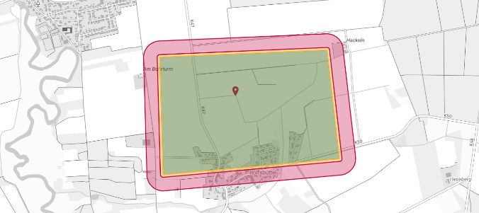 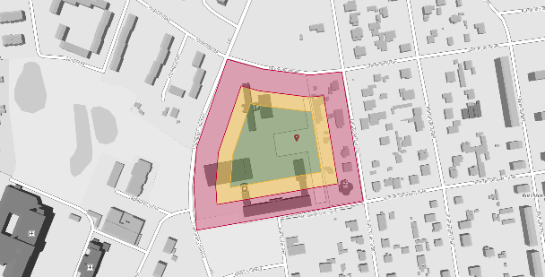 **Figure 9 — ‘Inside out’ versus ‘reverse’ computation of the flight area** Areas within the flight geography that need to be excluded for any reason (e.g. higher ground risk) should be addressed in the same way as to surround them with a contingency volume and a ground risk buffer. A screenshot of the flight area, accompanied by a concise description, all input values, and the calculations for contingency volume (CV) and ground risk buffer (GRB) should be documented. For instance, in Part C of the operations manual according to Chapter A.3. The content should be presented in a manner that is easily comprehensible to all parties involved in the operation, enabling swift access to all pertinent data during routine operations. It is also crucial for the competent authority to understand the calculation process. If the derivation of the calculation or the overall rationale is unusually extensive, it is advisable to relocate the sections not directly pertinent to daily operations to the operations manual annex. *Example:* Detailed information for each flight area is typically located under Part C, following the recommended format outlined in Chapter A.3 ‘Structure of the operations manual’. In a structured chapter layout, this may appear as follows: **3 Part C — Flight Areas** 3.2 Flight area *[**project name**]* **Description** The flight area, along with its precise coordinates, is delineated in the accompanying \*.kml file ‘*[project name.kml]*’. 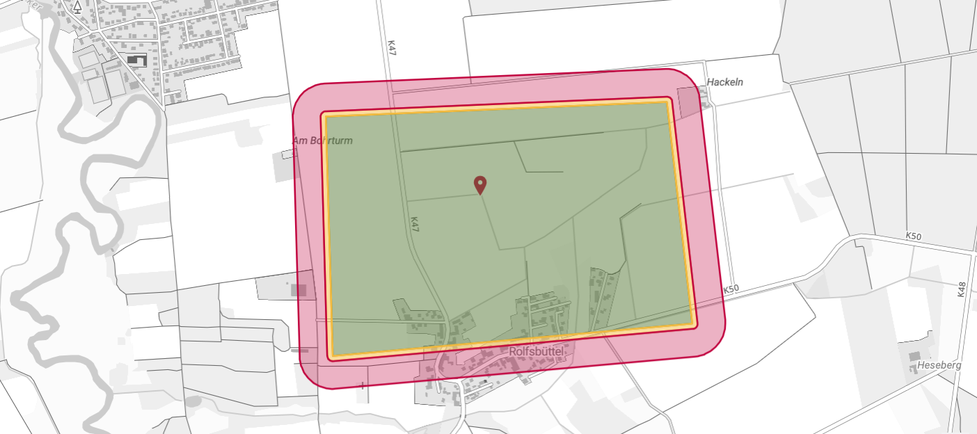 **Figure 7 — Graphical representation of a flight area** The centre of the figure is located at ***[******N53.1234567 E11.1234567******]***. The remote pilot’s position is located at ***[N53.1434567 E11.1434567]***. General comment: *[The flight area is an area used for agricultural purposes, etc.]* Special procedures/mitigations: *[CTR Clearance for airport XY is required, as per OM 2.2]* **Calculation of the contingency volume (CV) and the ground risk buffer (GRB)** The CV and the GRB were determined using the formulas described in paragraph A.5.2 of this annex. UA characteristics: — type: ***[rotary wing without parachute]***; — altitude measurement: ***[barometric]***; — maximum speed in operation *V*0: ***[10,0 m/s]***; — maximum permissible wind speed *V*Wind: ***[3,0 m/s]***; — characteristic dimension CD: ***[1,50 m]***; — maximum pitch angle Θmax: ***[45°]***. The following parameters were used: — height of the flight geography ***H*****FG**: ***[100,0 m]***; — calculation method:***[from inside]***; — manoeuvre on entering into the contingency volume (horizontal): ***[stopping]***; — manoeuvre on entering the contingency volume (vertical): ***[kinetic into potential]***; — manoeuvre on entering the ground risk buffer: ***[power off]***. Assumptions: — GNSS accuracy ***S*****GNSS**: ***[0,5 m]***; — position holding error ***S*****Pos**: ***[3,0 m]***; — map error ***S*****K**: ***[1,0 m]***; — reaction time ***t*****R**: ***[1,0 s]***; — altitude measurement error ***H*****AM**: ***[H******Baro*** ***= 1,0 m]***; — additional distance (horizontal) ***S*****Add**: ***[0,0 m]***; — additional distance (vertical) ***H*****Add**: ***[0,0 m]***. Reasons for deviations from the standard values: — *S*GNSS (***[0,5 m]*** instead of ***[3,0 m]***): ***[The UA is equipped with …]***; — …; — *H*CM (***[3,0 m]*** instead of ***[5,1 m]***): ***[The assumption based on …]***. **Results** Flight altitude: — Altitude of the flight geography ***H*****FG**: ***[100,0 m]***. Contingency volume: — Horizontal ***S*****CV**: ***[34,5 m]***; — Vertical ***H*****CV**:***[113,1 m]***. Ground risk buffer: — Horizontal ***S*****GRB**: ***[113,8 m]***. Adjacent ground area: — Horizontal **S****AA**:***[5000 m]***. 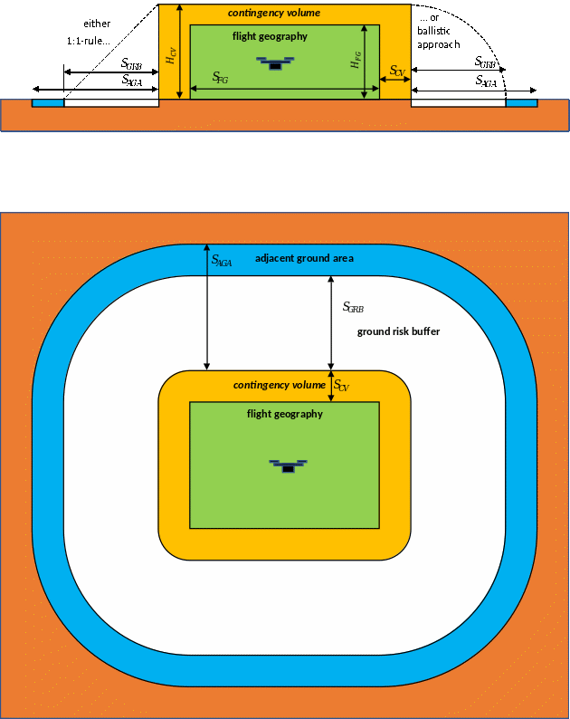 **Figure 8 — Schematic representation of the flight geography, the contingency volume and the ground risk buffer** **A.5.2 Calculations used in the example case in the paragraph above** **A.5.2.1 Information required for the calculations** <table cellpadding="7" cellspacing="0"> <col/> <col/> <tr> <td bgcolor="#dbe5f1"><p> <img align="absmiddle" name="Object1" src="source-marked.part-0000_html_4bb55653.gif"/> , m/s</p> </td> <td><p> Maximum operational speed that is flown. This corresponds to the information in point 3.6 in the operational authorisation application form provided in </p> <p> <u><a href="#_DxCrossRefBm1295819087">AMC1 UAS.SPEC.030(2)</a></u>.</p> <p><i>Note: A speed below 3 m/s for multirotor and 1.25</i><img align="absmiddle" name="Object2" src="source-marked.part-0000_html_6d6f6dea.gif"/> <i> for fixed-wing aircraft is not considered realistic.</i></p> </td> </tr> <tr> <td bgcolor="#dbe5f1"><p> CD, m</p> </td> <td><p> For the ‘maximum UA characteristic dimension (CD)’, please refer to definition I.141 ‘UA characteristic dimensions’ in <u><a href="#_DxCrossRefBm1295819074">Annex I</a></u> to this AMC. Propellers and rotors are part of the geometry, whereby their most unfavourable position is considered. This corresponds to the information in point 3.4 of the operational authorisation application form provided in <u><a href="#_DxCrossRefBm1295819087">AMC1 UAS.SPEC.030(2)</a></u>.</p> </td> </tr> <tr> <td bgcolor="#dbe5f1"><p> <img align="absmiddle" name="Object3" src="source-marked.part-0000_html_6556e123.gif"/> , m/s</p> </td> <td><p> Maximum wind speed specified in the operations manual up to which the UA may be operated.</p> </td> </tr> <tr> <td bgcolor="#dbe5f1"><p> FG</p> </td> <td><p> Flight geography</p> </td> </tr> <tr> <td bgcolor="#dbe5f1"><p> CV</p> </td> <td><p> Contingency volume</p> </td> </tr> <tr> <td bgcolor="#dbe5f1"><p> GRB</p> </td> <td><p> Ground risk buffer</p> </td> </tr> </table> **A.5.2.2 Computation of the flight geography** ***Variant 1 (‘inside out’)*** The size of the flight geography usually results from the operator’s desired flight geography. The contingency volume and the ground risk buffer just add up to this area. ***Variant 2 (‘reverse’)*** Determination of the maximum flight geography available, e.g. when operating over a controlled ground area. In this example (controlled ground), the ground projection of the flight geography, the contingency volume and the ground risk buffer should be completely contained in the controlled ground area. A calculation in reverse is recommended. The outer limit of the ground risk buffer corresponds to the topology of the controlled ground area. In the first step, the horizontal extent (width) of the ground risk buffer is subtracted from the topology of the controlled ground area. This gives the boundary between the contingency volume and the ground risk buffer. In the second step, the horizontal extent (width) of the contingency volume is then subtracted from this limit. This results in the maximum possible expansion of the flight geography as the remaining area. Notes on the realistic definition of particularly small flight geographies: <table cellpadding="7" cellspacing="0"> <col/> <col/> <tr> <td bgcolor="#dbe5f1"><p> <b>Flight geography (FG) horizontal</b></p> </td> <td><p> <br/> </p> </td> </tr> <tr> <td bgcolor="#dbe5f1"><p> Width of the flight geography: <img align="absmiddle" name="Object4" src="source-marked.part-0000_html_79296ffa.gif"/> </p> </td> <td><p align="center"> <img align="absmiddle" name="Object5" src="source-marked.part-0000_html_4b998125.gif"/> </p> </td> </tr> <tr> <td bgcolor="#dbe5f1"><p> <b>Flight geography (FG) vertical</b></p> </td> <td><p> <br/> </p> </td> </tr> <tr> <td bgcolor="#dbe5f1"><p> Height of the flight geography: <img align="absmiddle" name="Object6" src="source-marked.part-0000_html_ba9f6eed.gif"/> </p> </td> <td><p align="center"> <img align="absmiddle" name="Object7" src="source-marked.part-0000_html_1d52edfd.gif"/> </p> </td> </tr> <tr> <td bgcolor="#dbe5f1" colspan="2" valign="top"><p> <i>Note: Values smaller than </i> <img align="absmiddle" name="Object8" src="source-marked.part-0000_html_43a26b81.gif"/> <i> and </i> <img align="absmiddle" name="Object9" src="source-marked.part-0000_html_3e7809ff.gif"/> <i> are considered unrealistic, also for automated waypoint flights.</i></p> </td> </tr> </table> **A.5.2.3 Computation of the contingency volume** Notes on the realistic dimensioning of the contingency volume. Assumptions can be substituted with real values if evidence is available: <table cellpadding="7" cellspacing="0"> <col/> <col/> <tr> <td bgcolor="#dbe5f1"><p> <b>Contingency volume horizontal</b></p> </td> <td><p> <br/> </p> </td> </tr> <tr> <td bgcolor="#dbe5f1"><p> GNSS accuracy: <img align="absmiddle" name="Object10" src="source-marked.part-0000_html_c09e317d.gif"/> </p> </td> <td><p align="center"> <img align="absmiddle" name="Object11" src="source-marked.part-0000_html_e6507e37.gif"/> </p> </td> </tr> <tr> <td bgcolor="#dbe5f1"><p> Position holding error: <img align="absmiddle" name="Object12" src="source-marked.part-0000_html_9a441b6d.gif"/> </p> </td> <td><p align="center"> <img align="absmiddle" name="Object13" src="source-marked.part-0000_html_681df7ef.gif"/> </p> </td> </tr> <tr> <td bgcolor="#dbe5f1"><p> Map error: <img align="absmiddle" name="Object14" src="source-marked.part-0000_html_3977d600.gif"/> </p> </td> <td><p align="center"> <img align="absmiddle" name="Object15" src="source-marked.part-0000_html_1484c432.gif"/> </p> </td> </tr> <tr> <td bgcolor="#dbe5f1"><p> Reaction distance: <img align="absmiddle" name="Object16" src="source-marked.part-0000_html_596effd9.gif"/> </p> </td> <td><p> <u>Manual initiation of measures</u></p> <p> Reaction time: <img align="absmiddle" name="Object17" src="source-marked.part-0000_html_624a3674.gif"/> , with <img align="absmiddle" name="Object18" src="source-marked.part-0000_html_4bb55653.gif"/> results in</p> <p align="center"> <img align="absmiddle" name="Object19" src="source-marked.part-0000_html_49d21714.gif"/> </p> <p><i>Note: </i> <img align="absmiddle" name="Object20" src="source-marked.part-0000_html_3b3ca23c.gif"/> <i> may also be smaller in fully automatic systems (e.g. geofence).</i></p> </td> </tr> <tr> <td bgcolor="#dbe5f1"><p> Contingency manoeuvres: <img align="absmiddle" name="Object21" src="source-marked.part-0000_html_9ea562dc.gif"/> </p> </td> <td><p> <u>Multirotor — stopping</u></p> <p> Based on <img align="absmiddle" name="Object22" src="source-marked.part-0000_html_3412bcbd.gif"/> <i> </i>follows for a</p> <p> thrust to weight ratio of at least 2</p> <p align="center"> <img align="absmiddle" name="Object23" src="source-marked.part-0000_html_11a5d20.gif"/> </p> <p> and a maximum pitch angle of less than 45 degrees</p> <p align="center"> <img align="absmiddle" name="Object24" src="source-marked.part-0000_html_5b23cc54.gif"/> </p> <p> The minimum distance for stopping to hovering mode is:</p> <p align="center"> <img align="absmiddle" name="Object25" src="source-marked.part-0000_html_4b0fa3f.gif"/> </p> <p> <u>Fixed-wing aircraft –180° turn:</u></p> <p> Assumption: roll angle <img align="absmiddle" name="Object26" src="source-marked.part-0000_html_da8a7a43.gif"/> </p> <p> The radius for the turn is:</p> <p align="center"> <img align="absmiddle" name="Object27" src="source-marked.part-0000_html_ab4c18c5.gif"/> </p> </td> </tr> <tr> <td bgcolor="#dbe5f1"><p> Alternative contingency manoeuvre parachute: <img align="absmiddle" name="Object28" src="source-marked.part-0000_html_9ea562dc.gif"/> </p> </td> <td><p> Flight terminated with parachute triggered when leaving the </p> <p> FG<img align="absmiddle" name="Object29" src="source-marked.part-0000_html_1582bfa1.gif"/> Time to open the parachute</p> <p align="center"> <img align="absmiddle" name="Object30" src="source-marked.part-0000_html_69ae7c42.gif"/> </p> </td> </tr> <tr> <td bgcolor="#dbe5f1"><p> Horizontal extension of the contingency volume: <img align="absmiddle" name="Object31" src="source-marked.part-0000_html_412be0d4.gif"/> </p> </td> <td><p align="center"> <img align="absmiddle" name="Object32" src="source-marked.part-0000_html_774cac63.gif"/> </p> </td> </tr> <tr> <td bgcolor="#ffffff" colspan="2"><p> <br/> </p> </td> </tr> <tr> <td bgcolor="#dbe5f1"><p> <b>Examples</b></p> </td> <td><p> <br/> </p> </td> </tr> <tr> <td bgcolor="#dbe5f1"><p> Example: multirotors</p> <p> <img align="absmiddle" name="Object33" src="source-marked.part-0000_html_59e93a8f.gif"/> , <img align="absmiddle" name="Object34" src="source-marked.part-0000_html_78d55074.gif"/> ,<img align="absmiddle" name="Object35" src="source-marked.part-0000_html_544dc126.gif"/> </p> <p><br/> </p> </td> <td><p align="center"> <img align="absmiddle" name="Object36" src="source-marked.part-0000_html_877a9312.gif"/> </p> </td> </tr> <tr> <td bgcolor="#dbe5f1"><p> Example: fixed-wing aircraft</p> <p> <img align="absmiddle" name="Object37" src="source-marked.part-0000_html_abd424e5.gif"/> , <img align="absmiddle" name="Object38" src="source-marked.part-0000_html_d0df0978.gif"/> </p> <p><br/> </p> </td> <td><p align="center"> <img align="absmiddle" name="Object39" src="source-marked.part-0000_html_975bda24.gif"/> </p> </td> </tr> <tr> <td bgcolor="#dbe5f1"><p> <b>Contingency volume vertical</b></p> </td> <td><p> <br/> </p> </td> </tr> <tr> <td bgcolor="#dbe5f1"><p> Altitude measurement error: <img align="absmiddle" name="Object40" src="source-marked.part-0000_html_b11c81cd.gif"/> </p> </td> <td><p> <img align="absmiddle" name="Object41" src="source-marked.part-0000_html_947ec320.gif"/> for barometric altitude measurement</p> <p> or</p> <p> <img align="absmiddle" name="Object42" src="source-marked.part-0000_html_80c4d39e.gif"/> for GNSS-based altitude measurement.</p> <p><i>Note: When operating close to large buildings or between buildings in narrow streets, the altitude information provided by GNSS may not be reliable.</i></p> </td> </tr> <tr> <td bgcolor="#dbe5f1"><p> Reaction distance: <img align="absmiddle" name="Object43" src="source-marked.part-0000_html_87696688.gif"/> </p> </td> <td><p> <u>Manual initiation of measures</u></p> <p> Reaction time: <img align="absmiddle" name="Object44" src="source-marked.part-0000_html_624a3674.gif"/> , with 45° pitch angle </p> <p> <img align="absmiddle" name="Object45" src="source-marked.part-0000_html_4edf9e34.gif"/> </p> <p><i>Note: </i> <img align="absmiddle" name="Object46" src="source-marked.part-0000_html_3b3ca23c.gif"/> <sub><i> </i></sub><i>may also be smaller in fully automatic systems (e.g. geofence). If external services are used for command and control, their system latency should be taken into consideration.</i></p> </td> </tr> <tr> <td bgcolor="#dbe5f1"><p> Contingency manoeuvres: <img align="absmiddle" name="Object47" src="source-marked.part-0000_html_cc312a95.gif"/> </p> </td> <td><p> <u>For multirotor</u></p> <p> The forward kinetic energy is completely converted into potential energy.</p> <p> This results in</p> <p align="center"> <img align="absmiddle" name="Object48" src="source-marked.part-0000_html_45b0ea8f.gif"/> </p> <p> <u>For fixed-wing aircraft</u></p> <p> Exit the FG upwards with a 45° pitch angle, then fly on a constant circular path with <i>V</i><sub>0 </sub>and radius <i>r</i> until level flight is achieved.</p> <p> With</p> <p align="center"> <img align="absmiddle" name="Object49" src="source-marked.part-0000_html_d2ac0912.gif"/> </p> <p> results in the contingency manoeuvre height being approximately</p> <p align="center"> <img align="absmiddle" name="Object50" src="source-marked.part-0000_html_927c8af9.gif"/> </p> </td> </tr> <tr> <td bgcolor="#dbe5f1"><p> Alternate contingency manoeuvre parachute: <img align="absmiddle" name="Object51" src="source-marked.part-0000_html_cc312a95.gif"/> </p> </td> <td><p> Flight terminated with parachute triggered when leaving the FG</p> <p> <br/> <br/> </p> <p> Exit FG with 45° pitch angle</p> <p> <img align="absmiddle" name="Object52" src="source-marked.part-0000_html_58e50201.gif"/> Time to open the parachute</p> <p align="center"> <img align="absmiddle" name="Object53" src="source-marked.part-0000_html_8360fb1b.gif"/> </p> </td> </tr> <tr> <td bgcolor="#dbe5f1"><p> Contingency volume: <img align="absmiddle" name="Object54" src="source-marked.part-0000_html_2c50c449.gif"/> </p> </td> <td><p align="center"> <img align="absmiddle" name="Object55" src="source-marked.part-0000_html_a5966da6.gif"/> </p> </td> </tr> <tr> <td bgcolor="#ffffff" colspan="2"><p> <br/> </p> </td> </tr> <tr> <td bgcolor="#dbe5f1"><p> <b>Examples</b></p> </td> <td><p> <br/> </p> </td> </tr> <tr> <td bgcolor="#dbe5f1"><p> Height of the flight geography</p> </td> <td><p align="center"> <img align="absmiddle" name="Object56" src="source-marked.part-0000_html_84ff6aff.gif"/> </p> </td> </tr> <tr> <td bgcolor="#dbe5f1"><p> <br/> <br/> </p> <p>Example: multirotor: <img align="absmiddle" name="Object57" src="source-marked.part-0000_html_59e93a8f.gif"/> </p> </td> <td><p align="center"> <img align="absmiddle" name="Object58" src="source-marked.part-0000_html_fa05620d.gif"/> </p> </td> </tr> <tr> <td bgcolor="#dbe5f1"><p> <br/> <br/> </p> <p>Example: fixed-wing a/c: <img align="absmiddle" name="Object59" src="source-marked.part-0000_html_abd424e5.gif"/> </p> </td> <td><p align="center"> <img align="absmiddle" name="Object60" src="source-marked.part-0000_html_6e0e6ce8.gif"/> </p> </td> </tr> </table> **A.5.2.4 Computation of the ground risk buffer** <table cellpadding="7" cellspacing="0"> <col/> <col/> <tr> <td bgcolor="#dbe5f1"><p> <b>Ground risk buffer horizontal</b></p> </td> <td><p> <br/> </p> </td> </tr> <tr> <td bgcolor="#dbe5f1"><p> Simplified approach: 1:1 rule: <img align="absmiddle" name="Object61" src="source-marked.part-0000_html_94a7d41b.gif"/> </p> </td> <td><p align="center"> <img align="absmiddle" name="Object62" src="source-marked.part-0000_html_b7ca19f.gif"/> </p> </td> </tr> <tr> <td bgcolor="#dbe5f1"><p> Ballistic approach: <img align="absmiddle" name="Object63" src="source-marked.part-0000_html_94a7d41b.gif"/> </p> <p><i><b>Note: Only permitted for rotorcraft and multirotors!</b></i></p> </td> <td><p> <img align="absmiddle" name="Object64" src="source-marked.part-0000_html_d98b0632.gif"/> </p> </td> </tr> <tr> <td bgcolor="#dbe5f1"><p> Termination with parachute:<img align="absmiddle" name="Object65" src="source-marked.part-0000_html_7e0b5b95.gif"/> </p> <p><i>Note: Values below </i> <img align="absmiddle" name="Object66" src="source-marked.part-0000_html_4c0e1119.gif"/> <i> are not considered realistic for this computation.</i></p> </td> <td><p> <img align="absmiddle" name="Object67" src="source-marked.part-0000_html_58e50201.gif"/> Time to open the parachute</p> <p> From the rate of descent with the parachute open (<img align="absmiddle" name="Object68" src="source-marked.part-0000_html_fce7ba92.gif"/> ) and the maximum permissible wind speed for operation (<img align="absmiddle" name="Object69" src="source-marked.part-0000_html_6556e123.gif"/> ) results in</p> <p align="center"> <img align="absmiddle" name="Object70" src="source-marked.part-0000_html_a2794801.gif"/> </p> </td> </tr> <tr> <td bgcolor="#dbe5f1"><p> Termination with fixed-wing aircraft:<img align="absmiddle" name="Object71" src="source-marked.part-0000_html_7e0b5b95.gif"/> </p> </td> <td><p> — <u>Power is switched off</u>:</p> <p> A glide ratio of <img align="absmiddle" name="Object72" src="source-marked.part-0000_html_2dbd5b8c.gif"/> results in</p> <p align="center"> <img align="absmiddle" name="Object73" src="source-marked.part-0000_html_493f3d60.gif"/> </p> <p> — <u>Power is switched off and the flight control surfaces are permanently set in a way that no gliding is possible:</u></p> <p> The simplified approach can be chosen (1:1 rule).</p> </td> </tr> <tr> <td bgcolor="#ffffff" colspan="2"><p> <br/> </p> </td> </tr> <tr> <td bgcolor="#dbe5f1"><p> <b>Examples</b></p> </td> <td><p> <br/> </p> </td> </tr> <tr> <td bgcolor="#dbe5f1"><p> Simplified approach:</p> <p>Multirotor: <img align="absmiddle" name="Object74" src="source-marked.part-0000_html_59e93a8f.gif"/> , <img align="absmiddle" name="Object75" src="source-marked.part-0000_html_8010e9.gif"/> , <img align="absmiddle" name="Object76" src="source-marked.part-0000_html_359522fe.gif"/> </p> </td> <td><p align="center"> <img align="absmiddle" name="Object77" src="source-marked.part-0000_html_48693636.gif"/> </p> </td> </tr> <tr> <td bgcolor="#dbe5f1"><p> Ballistic approach:</p> <p>Multirotor: <img align="absmiddle" name="Object78" src="source-marked.part-0000_html_59e93a8f.gif"/> , <img align="absmiddle" name="Object79" src="source-marked.part-0000_html_8010e9.gif"/> , <img align="absmiddle" name="Object80" src="source-marked.part-0000_html_359522fe.gif"/> </p> </td> <td><p align="center"> <img align="absmiddle" name="Object81" src="source-marked.part-0000_html_1c37d146.gif"/> </p> </td> </tr> <tr> <td bgcolor="#dbe5f1"><p> Fixed-wing aircraft if only power is switched off: <img align="absmiddle" name="Object82" src="source-marked.part-0000_html_abd424e5.gif"/> , <img align="absmiddle" name="Object83" src="source-marked.part-0000_html_8585a610.gif"/> , <img align="absmiddle" name="Object84" src="source-marked.part-0000_html_3d377fe4.gif"/> , E=20</p> </td> <td><p align="center"> <img align="absmiddle" name="Object85" src="source-marked.part-0000_html_40e0556c.gif"/> </p> <p><br/> </p> </td> </tr> <tr> <td bgcolor="#dbe5f1"><p> Fixed-wing aircraft if power is switched off and flight control surfaces set so that no gliding is possible: <img align="absmiddle" name="Object86" src="source-marked.part-0000_html_abd424e5.gif"/> , <img align="absmiddle" name="Object87" src="source-marked.part-0000_html_8585a610.gif"/> , <img align="absmiddle" name="Object88" src="source-marked.part-0000_html_3d377fe4.gif"/> </p> </td> <td><p align="center"> <img align="absmiddle" name="Object89" src="source-marked.part-0000_html_62b88fde.gif"/> </p> </td> </tr> <tr> <td bgcolor="#dbe5f1"><p> <b>GRB vertical</b></p> </td> <td><p> — not applicable —</p> </td> </tr> </table> **A.5.2.5 Examples of computation of maximum distance(s) for VLOS / BVLOS with AOs** When determining the operating range for VLOS or BVLOS with AO operations, care should be taken to ensure that the remote pilot can actually operate the UAS within their visual range or within the visual range of the AOs. To check whether the described UAS operation is in VLOS or in BVLOS, the following calculations may be used. <table cellpadding="7" cellspacing="0"> <col/> <col/> <tr> <td bgcolor="#dbe5f1"><p> <br/> </p> </td> <td><p> <br/> </p> </td> </tr> <tr> <td bgcolor="#dbe5f1" valign="top"><p> <b>VLOS / BVLOS with AO limit</b></p> </td> <td><p> In VLOS or in BVLOS with AOs the air risk is mitigated by having the UA in sight of the remote pilot or of the AO. The maximum possible distance between the remote pilot or the AO and the UA results from the <u><b>smaller</b></u> <b>value of ALOS and DLOS</b>. Anything beyond that is considered <b>BVLOS</b>.</p> </td> </tr> <tr> <td bgcolor="#dbe5f1"><p> ALOS</p> </td> <td><p> Attitude line of sight (ALOS)</p> <p>The ALOS defines the maximum distance up to which a remote pilot can detect the position and orientation of the UA. Up to this limit, the remote pilot is able to control the flight path of the UA and is able to determine the attitude and position of the UA. This distance was determined in practical tests.</p> </td> </tr> <tr> <td bgcolor="#dbe5f1"><p> DLOS</p> </td> <td><p> Detection line of sight (DLOS)</p> <p>The DLOS defines the distance up to which the UA could theoretically fly while at the same time other aircraft in the same direction can be visually detected, and sufficient time is available for an avoidance manoeuvre. The ground visibility is crucial for this.</p> </td> </tr> <tr> <td bgcolor="#dbe5f1"><p> GV</p> </td> <td><p> Ground visibility (GV)</p> <p> The GV depends on the operational area and the meteorological conditions, and should be determined at the respective time of operation. The procedure for precisely determining GV should be described in a section of the OM related to procedures (e.g. Section 2.4 of the OM structure provided in A.3 of this annex). The use of landmarks or the use of a transmissometer is possible.</p> <p>The maximum ground visibility to be assumed is <b>5 km</b>, analogue to the visibility according to the VFR rules in airspace G<a href="#_ftn52" name="_ftnref52">[52]</a>.</p> </td> </tr> </table> <table cellpadding="7" cellspacing="0"> <col/> <col/> <tr> <td bgcolor="#dbe5f1" valign="top"><p> ALOS limit</p> </td> <td><p> <u>For rotorcraft and multirotors:</u></p> <p> <img align="absmiddle" name="Object90" src="source-marked.part-0000_html_3a3a5e9a.gif"/> </p> <p> <br/> <br/> </p> <p> <u>For fixed-wing aircraft:</u></p> <p><img align="absmiddle" name="Object91" src="source-marked.part-0000_html_c6d83cb9.gif"/> </p> </td> </tr> <tr> <td bgcolor="#dbe5f1" valign="top"><p> DLOS limit</p> </td> <td><p align="center"> <img align="absmiddle" name="Object92" src="source-marked.part-0000_html_c6f15e08.gif"/> </p> <p> The GV depends on the actual ground visibility at site and time of operation. However, the following always applies:</p> <p align="center"> <img align="absmiddle" name="Object93" src="source-marked.part-0000_html_6c7a8f1d.gif"/> </p> </td> </tr> </table> If the largest possible distance between the remote pilot’s location and the outer side of the CV (boundary between CV and GRB) is greater than the VLOS distance, no VLOS operation may take place. UAS operations should then take place in BVLOS. **A.5.2.6 Examples for maximum VLOS distances** The following table is valid for a ground visibility of 5 km or more. <table bgcolor="#d9d9d9" cellpadding="7" cellspacing="0"> <col/> <col/> <col/> <tr valign="top"> <td bgcolor="#808080" rowspan="2"><p align="left"> Characteristic dimension</p> <p align="left">(CD)</p> </td> <td bgcolor="#808080" colspan="2"><p align="left"> Maximum VLOS distance</p> </td> </tr> <tr valign="top"> <td bgcolor="#808080"><p align="left"> <b>Rotary wing</b></p> </td> <td bgcolor="#808080"><p align="left"> <b>Fixed wing</b></p> </td> </tr> <tr valign="top"> <td bgcolor="#808080"><p align="left"> <b>1 m</b></p> </td> <td bgcolor="#d9d9d9"><p align="left"> 347 m</p> </td> <td bgcolor="#d9d9d9"><p align="left"> 520 m</p> </td> </tr> <tr valign="top"> <td bgcolor="#808080"><p align="left"> <b>2 m</b></p> </td> <td bgcolor="#d9d9d9"><p align="left"> 674 m</p> </td> <td bgcolor="#d9d9d9"><p align="left"> 1 010 m</p> </td> </tr> <tr valign="top"> <td bgcolor="#808080"><p align="left"> <b>3 m</b></p> </td> <td bgcolor="#d9d9d9"><p align="left"> 1 000 m</p> </td> <td bgcolor="#d9d9d9"><p align="left"> 1 500 m</p> </td> </tr> <tr valign="top"> <td bgcolor="#808080"><p align="left"> <b>3,5 m</b></p> </td> <td bgcolor="#d9d9d9"><p align="left"> 1 164,5 m</p> </td> <td bgcolor="#d9d9d9"><p align="left"> 1 500 m</p> </td> </tr> <tr valign="top"> <td bgcolor="#808080"><p align="left"> <b>4 m</b></p> </td> <td bgcolor="#d9d9d9"><p align="left"> 1 328 m</p> </td> <td bgcolor="#d9d9d9"><p align="left"> 1 500 m</p> </td> </tr> <tr valign="top"> <td bgcolor="#808080"><p align="left"> <b>4,53 m</b></p> </td> <td bgcolor="#d9d9d9"><p align="left"> 1 500 m</p> </td> <td bgcolor="#d9d9d9"><p align="left"> 1 500 m</p> </td> </tr> <tr valign="top"> <td bgcolor="#808080"><p align="left"> <b>> 4,53 m</b></p> </td> <td bgcolor="#d9d9d9"><p align="left"> 1 500 m</p> </td> <td bgcolor="#d9d9d9"><p align="left"> 1 500 m</p> </td> </tr> </table> 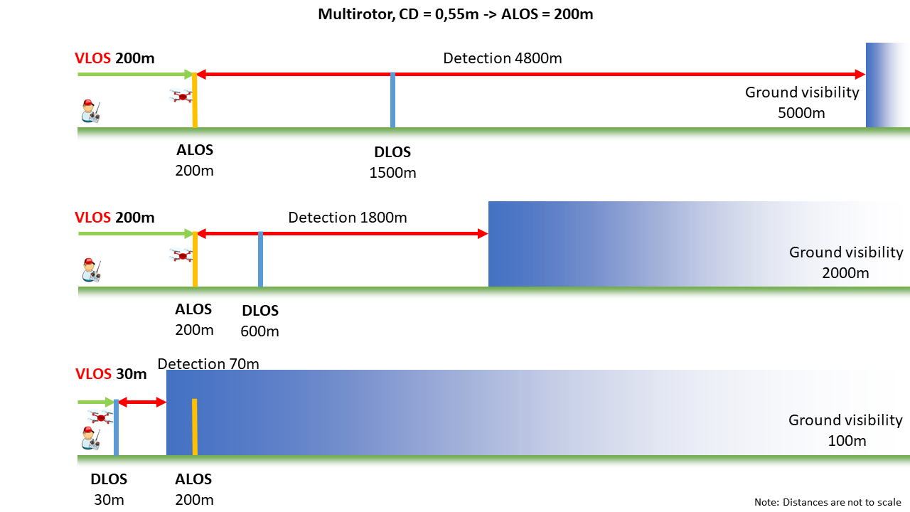 **Figure 9 — Multirotor VLOS range** 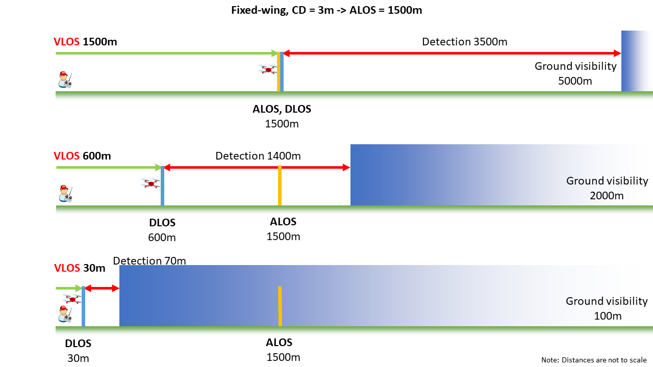 **Figure 10 — Fixed-wing VLOS range** --- [[50]](#_ftnref50) An example of an operations manual and modules providing dedicated procedures may be found on the EASA website at <https://www.easa.europa.eu/en/domains/drones-air-mobility/operating-drone/specific-category-civil-drones/predefined-risk-assessment-pdra#group-easa-downloads>. [[51]](#_ftnref51) <https://www.easa.europa.eu/en/domains/drones-air-mobility/operating-drone/specific-category-civil-drones#group-easa-downloads> [[52]](#_ftnref52) As any larger GV value is not deemed possible to extend the bare eye DLOS beyond the 1.5 km, provided that sufficient time for avoidance is still available.