Light
Dark
System
Log In
Loading...
Compare / EASA/
Incorporated Amendments
/
Compare & Highlight Differences
AIS.TR.360 Obstacle data sets
Available versions for ERULES-1963177438-17749
Regulation (EU) 2020/469
found in: ATM/ANS Provision of Services (2017/373) (Mar 2025)
From
ATM/ANS Provision ... (Mar 2025)
ATM/ANS Provision ... (Feb 2023)
From section
To
ATM/ANS Provision ... (Mar 2025)
ATM/ANS Provision ... (Feb 2023)
To section
No visible text changes
0 removals
0 additions
View
Rich
Plain
Sync scrolling
Share
From
Show details
Hide details
To
Show details
Hide details
Version
Show side by side
AIS.TR.360 Obstacle data sets Commission Implementing Regulation (EU) 2020/469 When obstacle data sets are provided in accordance with point [AIS.OR.360](#_DxCrossRefBm647743193): (a) obstacle data items are features that shall be represented in the data sets by points, lines or polygons; (b) all defined obstacle feature types shall be provided and each of them shall be described according to the following list of attributes: (1) area of coverage; (2) identification of the data originator; (3) data source identifier; (4) obstacle identifier; (5) horizontal accuracy; (6) horizontal confidence level; (7) horizontal position; (8) horizontal resolution; (9) horizontal extent; (10) horizontal reference system; (11) elevation; (12) vertical accuracy; (13) vertical confidence level; (14) vertical resolution; (15) vertical reference system; (16) obstacle type; (17) geometry type; (18) integrity; (19) date and time stamp; (20) unit of measurement used; (21) lighting; and (22) marking; (c) obstacle data for Areas 2 and 3 shall be collected in accordance with the following obstacle collection surfaces: (1) the Area 2a obstacle collection surface has a height of 3 m above the nearest runway elevation measured along the runway centre line, and for those portions related to a clearway, if one exists, at the elevation of the nearest runway end; (2) the Area 2b obstacle collection surface has a 1,2 % slope extending from the ends of Area 2a at the elevation of the runway end in the direction of departure, with a length of 10 km and a splay of 15 % to each side; obstacles less than 3 m in height above the ground need not be collected; (3) the Area 2c obstacle collection surface has a 1,2 % slope extending outside Areas 2a and 2b at a distance of not more than 10 km from the boundary of Area 2a; the initial elevation of Area 2c shall be the elevation of the point of Area 2a at which it commences; obstacles less than 15 m in height above the ground need not be collected; (4) the Area 2d obstacle collection surface has a height of 100 m above the ground; and (5) the Area 3 obstacle collection surface extends 0.5 m above the horizontal plane passing through the nearest point on the aerodrome movement area; (d) in those portions of Area 2 where flight operations are prohibited due to very high terrain or other local restrictions and/or regulations, obstacle data shall be collected and recorded in accordance with the Area 1 numerical requirements; (e) the obstacle data product specification, supported by geographical coordinates for each aerodrome included within the dataset, shall describe the following areas: (1) Areas 2a, 2b, 2c and 2d; (2) the take-off flight path area; and (3) the obstacle limitation surfaces; (f) obstacle data sets shall contain the digital representation of the vertical and horizontal extent of the obstacles; and (g) obstacles shall not be included in terrain data sets. Obstacle data collection surfaces – Area 1 and Area 2 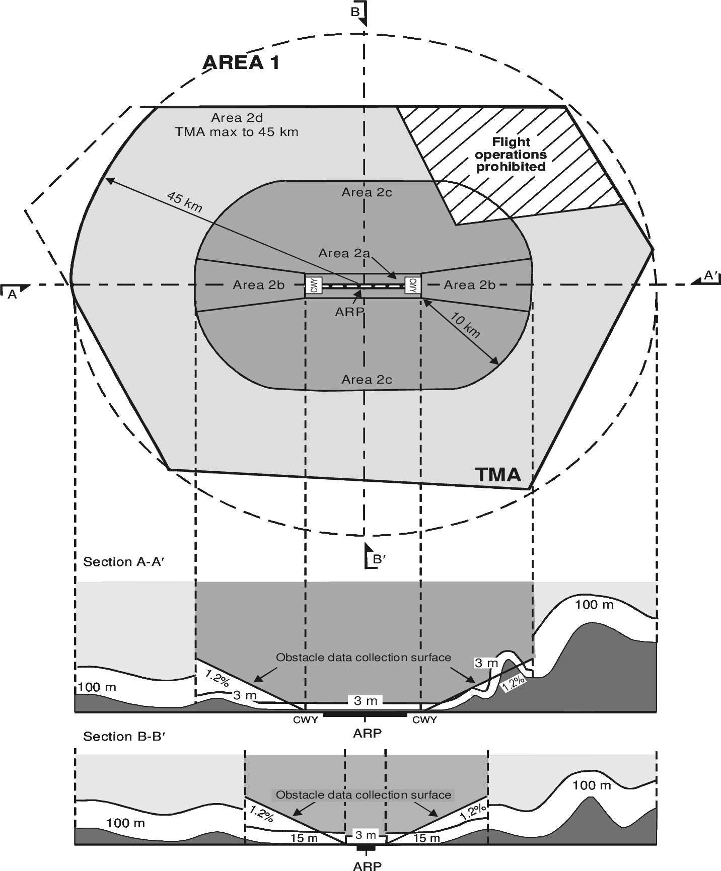
AIS.TR.360 Obstacle data sets Commission Implementing Regulation (EU) 2020/469 When obstacle data sets are provided in accordance with point [AIS.OR.360](#_DxCrossRefBm1726556012): (a) obstacle data items are features that shall be represented in the data sets by points, lines or polygons; (b) all defined obstacle feature types shall be provided and each of them shall be described according to the following list of attributes: (1) area of coverage; (2) identification of the data originator; (3) data source identifier; (4) obstacle identifier; (5) horizontal accuracy; (6) horizontal confidence level; (7) horizontal position; (8) horizontal resolution; (9) horizontal extent; (10) horizontal reference system; (11) elevation; (12) vertical accuracy; (13) vertical confidence level; (14) vertical resolution; (15) vertical reference system; (16) obstacle type; (17) geometry type; (18) integrity; (19) date and time stamp; (20) unit of measurement used; (21) lighting; and (22) marking; (c) obstacle data for Areas 2 and 3 shall be collected in accordance with the following obstacle collection surfaces: (1) the Area 2a obstacle collection surface has a height of 3 m above the nearest runway elevation measured along the runway centre line, and for those portions related to a clearway, if one exists, at the elevation of the nearest runway end; (2) the Area 2b obstacle collection surface has a 1,2 % slope extending from the ends of Area 2a at the elevation of the runway end in the direction of departure, with a length of 10 km and a splay of 15 % to each side; obstacles less than 3 m in height above the ground need not be collected; (3) the Area 2c obstacle collection surface has a 1,2 % slope extending outside Areas 2a and 2b at a distance of not more than 10 km from the boundary of Area 2a; the initial elevation of Area 2c shall be the elevation of the point of Area 2a at which it commences; obstacles less than 15 m in height above the ground need not be collected; (4) the Area 2d obstacle collection surface has a height of 100 m above the ground; and (5) the Area 3 obstacle collection surface extends 0.5 m above the horizontal plane passing through the nearest point on the aerodrome movement area; (d) in those portions of Area 2 where flight operations are prohibited due to very high terrain or other local restrictions and/or regulations, obstacle data shall be collected and recorded in accordance with the Area 1 numerical requirements; (e) the obstacle data product specification, supported by geographical coordinates for each aerodrome included within the dataset, shall describe the following areas: (1) Areas 2a, 2b, 2c and 2d; (2) the take-off flight path area; and (3) the obstacle limitation surfaces; (f) obstacle data sets shall contain the digital representation of the vertical and horizontal extent of the obstacles; and (g) obstacles shall not be included in terrain data sets. Obstacle data collection surfaces – Area 1 and Area 2 ![Aviation.Bot AI suggestion, not from EASA source: [Image caption skipped for debugging]](/static/files/file_gqs63YSDadR/image096.png)