Light
Dark
System
Log In
Loading...
Compare / EASA/
Incorporated Amendments
/
Compare & Highlight Differences
AMC3 ATS.TR.210(c)(2)(i) Operation of air traffic control service
Available versions for ERULES-1963177438-17215
ED Decision 2020/008/R
found in: ATM/ANS Provision of Services (2017/373) (Mar 2025)
From
ATM/ANS Provision ... (Mar 2025)
ATM/ANS Provision ... (Feb 2023)
From section
To
ATM/ANS Provision ... (Mar 2025)
ATM/ANS Provision ... (Feb 2023)
To section
No visible text changes
0 removals
0 additions
View
Rich
Plain
Sync scrolling
Share
From
Show details
Hide details
To
Show details
Hide details
Version
Show side by side
AMC3 ATS.TR.210(c)(2)(i) Operation of air traffic control service ED Decision 2020/008/R PROCEDURAL SEPARATION — LONGITUDINAL SEPARATION MINIMA BASED ON DISTANCE USING DISTANCE MEASURING EQUIPMENT (DME) AND/OR GNSS — AIRCRAFT AT THE SAME CRUISING LEVEL Longitudinal separation minima based on distance using distance measuring equipment (DME) and/or GNSS should be established between aircraft at the same cruising level, as follows: (a) Aircraft on the same track (1) 37 km (20 NM), provided: (i) each aircraft utilises: (A) the same ‘on-track’ DME station when both aircraft are utilising DME; or (B) an ‘on-track’ DME station and a collocated waypoint when one aircraft is utilising DME and the other is utilising GNSS; or (C) the same waypoint when both aircraft are utilising GNSS; and (ii) separation is checked by obtaining simultaneous DME and/or GNSS readings from the aircraft at frequent intervals to ensure that the minimum will not be infringed (see Figure 23); 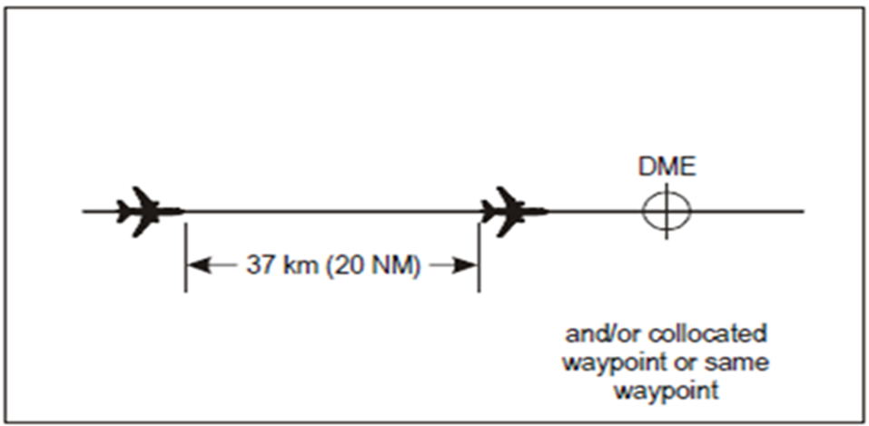 Figure 23: 37 km (20 NM) DME and/or GNSS-based separation between aircraft on the same track and same level (2) 19 km (10 NM), provided: (i) the leading aircraft maintains a TAS of 37 km/h (20 kt) or more faster than the succeeding aircraft; (ii) each aircraft utilises: (A) the same ‘on-track’ DME station when both aircraft are utilising DME; or (B) an ‘on-track’ DME station and a collocated waypoint when one aircraft is utilising DME and the other is utilising GNSS; or (C) the same waypoint when both aircraft are utilising GNSS; and (iii) separation is checked by obtaining simultaneous DME and/or GNSS readings from the aircraft at such intervals as are necessary to ensure that the minimum is established and will not be infringed (see Figure 24). 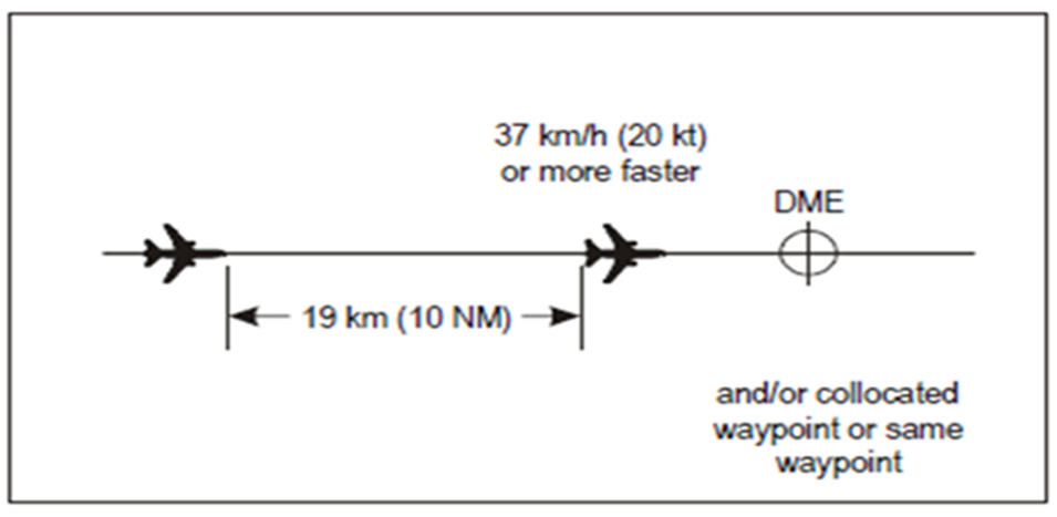 Figure 24: 19 km (10 NM) DME and/or GNSS-based separation between aircraft on the same track and same level (b) Aircraft on crossing tracks The longitudinal separation prescribed in point (a) should also apply, provided each aircraft reports distance from the DME station and/or collocated waypoint or same waypoint located at the crossing point of the tracks and that the relative angle between the tracks is less than 90 degrees (see Figures 25 and 26). 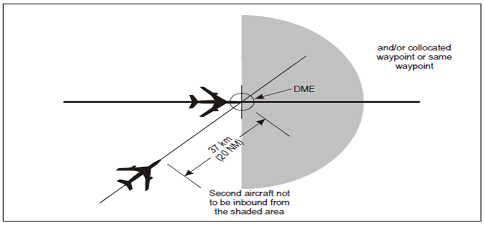 Figure 25: 37 km (20 NM) DME and/or GNSS-based separation between aircraft on crossing tracks and the same level 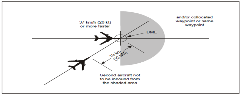 Figure 26: 19 km (10 NM) DME and/or GNSS-based separation between aircraft on crossing tracks and the same level
AMC3 ATS.TR.210(c)(2)(i) Operation of air traffic control service ED Decision 2020/008/R PROCEDURAL SEPARATION — LONGITUDINAL SEPARATION MINIMA BASED ON DISTANCE USING DISTANCE MEASURING EQUIPMENT (DME) AND/OR GNSS — AIRCRAFT AT THE SAME CRUISING LEVEL Longitudinal separation minima based on distance using distance measuring equipment (DME) and/or GNSS should be established between aircraft at the same cruising level, as follows: (a) Aircraft on the same track (1) 37 km (20 NM), provided: (i) each aircraft utilises: (A) the same ‘on-track’ DME station when both aircraft are utilising DME; or (B) an ‘on-track’ DME station and a collocated waypoint when one aircraft is utilising DME and the other is utilising GNSS; or (C) the same waypoint when both aircraft are utilising GNSS; and (ii) separation is checked by obtaining simultaneous DME and/or GNSS readings from the aircraft at frequent intervals to ensure that the minimum will not be infringed (see Figure 23); ![Aviation.Bot AI suggestion, not from EASA source: [Image caption skipped for debugging]](/static/files/file_gqs63YSDadR/image036.png) Figure 23: 37 km (20 NM) DME and/or GNSS-based separation between aircraft on the same track and same level (2) 19 km (10 NM), provided: (i) the leading aircraft maintains a TAS of 37 km/h (20 kt) or more faster than the succeeding aircraft; (ii) each aircraft utilises: (A) the same ‘on-track’ DME station when both aircraft are utilising DME; or (B) an ‘on-track’ DME station and a collocated waypoint when one aircraft is utilising DME and the other is utilising GNSS; or (C) the same waypoint when both aircraft are utilising GNSS; and (iii) separation is checked by obtaining simultaneous DME and/or GNSS readings from the aircraft at such intervals as are necessary to ensure that the minimum is established and will not be infringed (see Figure 24). ![Aviation.Bot AI suggestion, not from EASA source: [Image caption skipped for debugging]](/static/files/file_gqs63YSDadR/image037.png) Figure 24: 19 km (10 NM) DME and/or GNSS-based separation between aircraft on the same track and same level (b) Aircraft on crossing tracks The longitudinal separation prescribed in point (a) should also apply, provided each aircraft reports distance from the DME station and/or collocated waypoint or same waypoint located at the crossing point of the tracks and that the relative angle between the tracks is less than 90 degrees (see Figures 25 and 26). ![Aviation.Bot AI suggestion, not from EASA source: [Image caption skipped for debugging]](/static/files/file_gqs63YSDadR/image038.png) Figure 25: 37 km (20 NM) DME and/or GNSS-based separation between aircraft on crossing tracks and the same level ![Aviation.Bot AI suggestion, not from EASA source: [Image caption skipped for debugging]](/static/files/file_gqs63YSDadR/image039.png) Figure 26: 19 km (10 NM) DME and/or GNSS-based separation between aircraft on crossing tracks and the same level