Light
Dark
System
Log In
Loading...
Compare / EASA/
Incorporated Amendments
/
Compare & Highlight Differences
AMC1 UAS.SPEC.040(1) Operational authorisation -- EASA Form 209
Available versions for ERULES-1963177438-15589
ED Decision 2022/002/R
found in: Unmanned Aircraft Systems (2019/947 and 2019/945) Part-UAS (Jul 2024)
ED Decision 2025/018/R
found in: Unmanned Aircraft Systems (Jun 2026)
From
Unmanned Aircraft ... (Jun 2026)
Unmanned Aircraft ... (Jul 2024)
From section
To
Unmanned Aircraft ... (Jun 2026)
Unmanned Aircraft ... (Jul 2024)
To section
No visible text changes
0 removals
0 additions
View
Rich
Plain
Sync scrolling
Share
From
Show details
Hide details
To
Show details
Hide details
Version
Show side by side
AMC1 UAS.SPEC.040(1) Operational authorisation ED Decision 2022/002/R OPERATIONAL AUTHORISATION TEMPLATE The competent authority should produce the operational authorisation according to the following form: <table border="1" cellpadding="0" cellspacing="0" width="706"><tr><td valign="top" width="91"></td><td colspan="7" valign="top" width="527"><p align="center"><b>Operational authorisation for the ‘specific’ category</b></p></td><td valign="top" width="88"><p align="center"><div class="image-container"><img alt="EASA EAR image" src="/static/files/file_5I6t1EH0lEH/image020.png"/></div></p></td></tr><tr><td colspan="9" valign="top" width="706"><p align="center"><b>1. Authority that issues the authorisation</b></p></td></tr><tr><td colspan="4" valign="top" width="342"><p><b>1.1 1 Issuing authority</b></p></td><td colspan="5" valign="top" width="364"></td></tr><tr><td colspan="4" valign="top" width="342"><p><b>1.2 Point of contact</b></p><p><b>Name</b></p><p><b>Telephone</b></p><p><b>Email</b></p></td><td colspan="5" valign="top" width="364"></td></tr><tr><td colspan="9" valign="top" width="706"><p align="center"><b>2.</b><b>UAS operator data</b></p></td></tr><tr><td colspan="4" valign="top" width="342"><p><b>2.1 UAS operator registration number</b></p></td><td valign="top" width="73"></td><td colspan="2" valign="top" width="137"><p></p></td><td colspan="2" valign="top" width="154"></td></tr><tr><td colspan="4" valign="top" width="342"><p><b>2.2 UAS operator name</b></p></td><td colspan="5" valign="top" width="364"></td></tr><tr><td colspan="4" valign="top" width="342"><p><b>2.3 Point of contact</b></p><p><b>Name</b></p><p><b>Telephone</b></p><p><b>Email</b></p></td><td colspan="5" valign="top" width="364"></td></tr><tr><td colspan="9" valign="top" width="706"><p align="center"><b>3. Authorised operation</b></p></td></tr><tr><td colspan="4" valign="top" width="342"><p><b>3.1 Authorised location(s)</b></p></td><td colspan="5" valign="top" width="364"></td></tr><tr><td colspan="4" valign="top" width="342"><p><b>3.2 Extent of the adjacent area</b></p></td><td colspan="5" valign="top" width="364"><p>____ km</p></td></tr><tr><td colspan="4" valign="top" width="342"><p><b>3.3 Risk assessment reference and revision</b></p></td><td colspan="5" valign="top" width="364"><p> SORA version __ PDRA # __-__ other _________</p></td></tr><tr><td colspan="4" valign="top" width="342"><p><b>3.4 Level of assurance and integrity</b></p></td><td colspan="5" valign="top" width="364"></td></tr><tr><td colspan="4" valign="top" width="342"><p><b>3.5 Type of operation</b></p></td><td colspan="5" valign="top" width="364"><p> VLOS BVLOS </p></td></tr><tr><td colspan="4" valign="top" width="342"><p><b>3.6 Transport of dangerous goods</b></p></td><td colspan="5" valign="top" width="364"><p> Yes No </p></td></tr><tr><td colspan="3" rowspan="2" valign="top" width="170"><p><b>3.7 Ground risk characterisation</b></p></td><td valign="top" width="172"><p><b>3.7.1 Operational area</b></p></td><td colspan="5" valign="top" width="364"></td></tr><tr><td valign="top" width="172"><p><b>3.7.2 Adjacent area</b></p></td><td colspan="5" valign="top" width="364"></td></tr><tr><td colspan="3" rowspan="2" valign="top" width="170"><p><b>3.8 Ground risk mitigations</b></p></td><td valign="top" width="172"><p><b>3.8.1 Strategic mitigations</b></p></td><td colspan="5" valign="top" width="364"><p> No Yes, low Yes, medium Yes, high </p></td></tr><tr><td valign="top" width="172"><p><b>3.8.2 ERP</b></p></td><td colspan="5" valign="top" width="364"><p> No Yes, low Yes, medium Yes, high </p></td></tr><tr><td colspan="4" valign="top" width="342"><p><b>3.9 Height limit of the operational volume</b></p></td><td colspan="5" valign="top" width="364"><p>_____ m (______ ft)</p></td></tr><tr><td colspan="3" rowspan="2" valign="top" width="170"><p><b>3.10 Residual air risk level</b></p></td><td valign="top" width="172"><p><b>3.10.1 Operational volume</b></p></td><td colspan="5" valign="top" width="364"><p> ARC-a ARC-b ARC-c ARC-d</p></td></tr><tr><td valign="top" width="172"><p><b>3.10.2. Adjacent volume</b></p></td><td colspan="5" valign="top" width="364"><p> ARC-a ARC-b ARC-c ARC-d</p></td></tr><tr><td colspan="3" rowspan="2" valign="top" width="170"><p><b>3.11 Air risk mitigations</b></p></td><td valign="top" width="172"><p><b>3.11.1 Strategic mitigations</b></p></td><td colspan="5" valign="top" width="364"><p> No Yes </p><p>If yes, please describe _________________</p></td></tr><tr><td valign="top" width="172"><p><b>3.11.2 Tactical mitigation methods</b></p></td><td colspan="5" valign="top" width="364"></td></tr><tr><td colspan="4" valign="top" width="342"><p><b>3.12 Achieved level of containment</b></p></td><td colspan="5" valign="top" width="364"><p> Basic Enhanced </p></td></tr><tr><td colspan="4" valign="top" width="342"><p><b>3.13 Remote pilot competency</b></p></td><td colspan="5" valign="top" width="364"></td></tr><tr><td colspan="4" valign="top" width="342"><p><b>3.14 Competency of staff, other than the remote pilot, essential for the safety of the operation</b></p></td><td colspan="5" valign="top" width="364"></td></tr><tr><td colspan="4" valign="top" width="342"><p><b>3.15 Type of events to be reported to the competent authority (in addition to those required by </b><a href="https://eur-lex.europa.eu/legal-content/EN/TXT/?uri=CELEX%3A32014R0376&qid=1653924064274"><b>Regulation (EU) No 376/2014</b></a><b>)</b></p></td><td colspan="5" valign="top" width="364"></td></tr><tr><td colspan="4" valign="top" width="342"><p><b>3.16 Insurance</b></p></td><td colspan="5" valign="top" width="364"><p> No Yes </p></td></tr><tr><td colspan="4" valign="top" width="342"><p><b>3.17 Operations manual reference</b></p></td><td colspan="5" valign="top" width="364"></td></tr><tr><td colspan="4" valign="top" width="342"><p><b>3.18 Compliance evidence file reference</b></p></td><td colspan="5" valign="top" width="364"></td></tr><tr><td colspan="4" valign="top" width="342"><p><b>3.19 Remarks / additional limitations</b></p></td><td colspan="5" valign="top" width="364"></td></tr><tr><td colspan="9" valign="top" width="706"><p align="center"><b>4. Data of authorised UAS</b></p></td></tr><tr><td colspan="2" valign="top" width="138"><p><b>4.1 Manufacturer</b></p></td><td colspan="2" valign="top" width="204"></td><td colspan="2" valign="top" width="180"><p><b>4.2 Model</b></p></td><td colspan="3" valign="top" width="184"></td></tr><tr><td colspan="2" valign="top" width="138"><p><b>4.3 Type of UAS</b></p></td><td colspan="2" valign="top" width="204"><p>Aeroplane Helicopter</p><p>Multirotor Hybrid/VTOL</p><p>Lighter than air / other</p></td><td colspan="2" valign="top" width="180"><p><b>4.4 Maximum characteristic dimensions</b></p></td><td colspan="3" valign="top" width="184"><p>_____ m</p></td></tr><tr><td colspan="2" valign="top" width="138"><p><b>4.5 Take-off mass</b></p></td><td colspan="2" valign="top" width="204"><p>_____ kg</p></td><td colspan="2" valign="top" width="180"><p><b>4.6 Maximum speed</b></p></td><td colspan="3" valign="top" width="184"><p>_____ m/s (_____ kt)</p></td></tr><tr><td colspan="4" valign="top" width="342"><p><b>4.7 Additional technical requirements</b></p></td><td colspan="5" valign="top" width="364"></td></tr><tr><td colspan="4" valign="top" width="342"><p><b>4.8 Serial number or, if applicable, UA registration mark</b></p></td><td colspan="5" valign="top" width="364"></td></tr><tr><td colspan="4" valign="top" width="342"><p><b>4.9 Number of type certificate (TC) or design verification report, if required</b></p></td><td colspan="5" valign="top" width="364"></td></tr><tr><td colspan="4" valign="top" width="342"><p><b>4.10 Number of the certificate of airworthiness (CofA), if required</b></p></td><td colspan="5" valign="top" width="364"></td></tr><tr><td colspan="4" valign="top" width="342"><p><b>4.11 Number of the noise certificate, if required</b></p></td><td colspan="5" valign="top" width="364"></td></tr><tr><td colspan="4" valign="top" width="342"><p><b>4.12 Mitigation to reduce effect of ground impact</b></p></td><td colspan="5" valign="top" width="364"><p> No Yes, low Yes, medium Yes, high</p><p>Required to reduce the ground risk Yes No</p></td></tr><tr><td colspan="4" valign="top" width="342"><p><b>4.13 Technical requirements for containment</b></p></td><td colspan="5" valign="top" width="364"><p> Basic Enhanced</p></td></tr><tr><td colspan="9" valign="top" width="706"><p align="center"><b>5. Remarks</b></p></td></tr><tr><td colspan="9" valign="top" width="706"></td></tr><tr><td colspan="9" valign="top" width="706"><p align="center"><b>6. Operational authorisation</b></p></td></tr><tr><td colspan="9" valign="top" width="706"><p><div class="image-container"><img alt="EASA EAR image" src="/static/files/file_5I6t1EH0lEH/image021.png"/></div>____________ (UAS operator name) is authorised to conduct UAS operations with the UAS(s) defined in Section 4 and according to the conditions and limitations defined in Section 3, for as long as it complies with this operational authorisation, with <a href="https://eur-lex.europa.eu/legal-content/EN/TXT/?uri=CELEX%3A32019R0947&qid=1653924125692">Regulation (EU) 2019/947</a>, and with any applicable Union and national regulations related to privacy, data protection, liability, insurance, security, and environmental protection.</p></td></tr><tr><td colspan="4" valign="top" width="342"><p><b>6.1 Operational authorisation number</b></p></td><td colspan="5" valign="top" width="364"></td></tr><tr><td colspan="4" valign="top" width="342"><p><b>6.2 Expiry date</b></p></td><td colspan="5" valign="top" width="364"><p>DD/MM/YYYY</p></td></tr><tr><td colspan="4" valign="top" width="342"><p><b>Date</b></p><p>DD/MM/YYYY</p></td><td colspan="5" valign="top" width="364"><p><b>Signature and stamp</b></p></td></tr><tr height="0"></tr></table> Instructions for filling in the operational authorisation form 1.1 Name of the competent authority that issues the operational authorisation, including the name of the State. 1.2 Contact details of the competent authority staff responsible for the file. 2.1 UAS operator registration number in accordance with [Article 14](#_DxCrossRefBm1106656821) of the UAS Regulation. 2.2 UAS operator’s name, as registered in the UAS operator registration database. 2.3 Contact details of the person responsible for the UAS operation, in charge to answer possible operational questions raised by the competent authority. 3.1 Location(s) where the UAS operator is authorised to operate. The identification of the location(s) should contain the full operational volume and ground risk buffer (the red line in Figure 2). Depending on the initial ground and air risk and on the application of mitigation measures, the location(s) may be ‘generic’ or ‘precise’ (refer to [GM2 UAS.SPEC.030(2)](#_DxCrossRefBm1106656820)). When the UAS operation is conducted in a MS other than the State of registration, the competent authority of the MS of registration should specify the location(s) only after receiving confirmation from the State of operation, according to [Article 13](#_DxCrossRefBm1106656813) of the UAS Regulation. 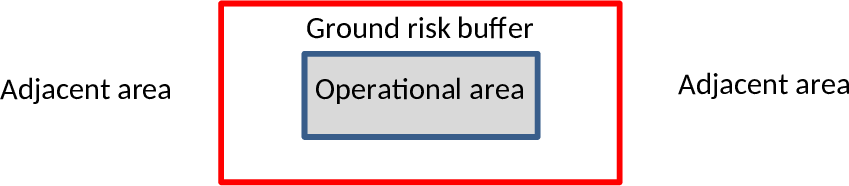 Figure 2 — Operational area and ground risk buffer 3.2 Provide the maximum distance in km to be considered for the adjacent area, starting from the limits of the ground risk buffer. 3.3 Select one of the three options. If the SORA is used, indicate the version. In case a PDRA is used, indicate the number and its revision. In case a risk assessment methodology is used other than the SORA, provide its reference. In this last case, the UAS operator should demonstrate that the methodology complies with [Article 11](#_DxCrossRefBm1106656763) of the UAS Regulation. 3.4 If the risk methodology used is the SORA, indicate the final SAIL of the operation, otherwise the equivalent information provided by the risk assessment methodology used. 3.5 Select one of the two options. 3.6 Select one of the two options. 3.7 Characterise the ground risk (i.e. density of overflown population density, expressed in persons per km2, if available, or ‘controlled ground area’, ‘sparsely populated area’, ‘populated area’, ‘gatherings of people’) for both the operational and the adjacent area. 3.8.1 Select one of the four options. In case the risk assessment is based on the SORA, this consists in M1 mitigation. 3.8.2 Select one of the four options. In case the risk assessment is based on the SORA, this consists in M3 mitigation. 3.9. Insert the maximum flight altitude, expressed in metres and feet in parentheses, of the approved operational volume (adding the air risk buffer, if applicable) using the AGL reference when the upper limit is below 150 m (492 ft), or use the MSL reference when the upper limit is above 150 m (492 ft). 3.10 Select one of the four options. 3.11.1 Select one of the two options. 3.11.2 Describe the tactical mitigation methods to be applied by the UAS operator. 3.12 Select one of the two options. 3.13 Specify the type of the remote pilot certificate, if required; otherwise, indicate ‘Declared’. 3.14 Specify the type of the certificate for the staff, other than the remote pilot, essential for the safety of the operation, if required; otherwise, indicate ‘Declared’. 3.15 List the type of events that the UAS operator should report to the competent authority, in addition to those required by [Regulation (EU) No 376/2014](https://eur-lex.europa.eu/legal-content/EN/TXT/?uri=CELEX%3A32014R0376&qid=1653924064274), if applicable. 3.16 Select one of the two options. 3.17 Indicate the OM’s identification and revision number. 3.18 Indicate the compliance evidence file identification and revision number. 3.19 Additional limitations defined by the competent authority. 4. Only the UAS features/characteristics required to be used for the operation should be identified in the form (e.g. in case the UAS qualifies for enhanced containment but the operation requires a basic containment, and the operator developed consistent procedures, then the basic containment should be ticked). 4.1 Name of the manufacturer of the UAS. 4.2 Model of the UAS as defined by the manufacturer. 4.3 Select one of the five options. 4.4 Indicate the maximum dimensions of the UA in metres (e.g. for aeroplanes: the length of the wingspan; for helicopters: the diameter of the propellers; for multirotors: the maximum distance between the tips of two opposite propellers) as used in the risk assessment to identify the ground risk. 4.5 Indicate the maximum value, expressed in kg, of the UA take-off mass (TOM), at which the UAS operation may be operated. All flights should then be operated not exceeding that TOM. The TOM maybe be different from (however, not higher than) the MTOM defined by the UAS manufacturer. 4.6 Maximum cruise airspeed, expressed in m/s and kt in parentheses, as defined in the manufacturer’s instructions. 4.7 List any additional technical requirements established by the competent authority. 4.8 Unique serial number (SN) of the UA defined by the manufacturer according to standard ANSI/CTA‑2063‑A‑2019, *Small Unmanned Aerial Systems Serial Numbers*, 2019, or the UA registration mark if the UA is registered. In case of privately built UAS or UAS not equipped with a unique SN, insert the unique SN of the remote identification system. 4.9 Include the EASA TC number, or the UAS design verification report number issued by EASA, as required by the competent authority. 4.10 If a UAS with an EASA TC is required, the UAS should have a certificate of airworthiness (CofA), and the competent authority should require compliance with the continuing airworthiness rules. 4.11 If a UAS with an EASA TC is required, the UAS should have a noise certificate. 4.12 Select one of the four options of the first row. In case the risk assessment is based on the SORA, this consists in M2 mitigation. Even if the UAS may be equipped with such system, this mitigation may not be required in the operation to reduce the ground risk. In this case, in the second row select ‘NO’. If the mitigation is instead used to reduce the ground risk, select ‘YES’ and the operator is required to include in the OM the related procedures. 4.13 Select one of the two options. 5 Free-text field for the addition of any relevant remark. 6.1 Reference number of the operational authorisation, as issued by the competent authority. The number should have the following format: NNN-OAT-xxxxx/yyy Where: — ‘NNN’ is the ISO 3166 Alpha-3 code of the Member State that issues the operational authorisation; — ‘OAT’ is a fixed field meaning ‘operational authorisation’; — ‘xxxxx’ are up to 12 alphanumeric characters defining the operational authorisation number; and — ‘yyy’ are 3 alphanumeric characters defining the revision number of the operational authorisation; each amendment of the operational authorisation will determine a new revision number. 6.2 The duration of the operational authorisation may be unlimited; in this case, indicate ‘Unlimited’. The authorisation will be valid for as long as the UAS operator complies with the relevant requirements of the UAS Regulation and with the conditions defined in the operational authorisation. Note 1: In section 4, more than one UAS may be listed. If needed, the fields may be duplicated. Note 2: The signature and stamp may be provided in electronic form. The quick response (QR) code should provide the link to the national database where the operational authorisation is stored.
##### AMC1 UAS.SPEC.040(1) Operational authorisation — EASA Form 209 *ED Decision 2025/018/R* **OPERATIONAL AUTHORISATION TEMPLATE** The competent authority should produce the operational authorisation according to the following form: <table cellpadding="7" cellspacing="0"> <col/> <col/> <col/> <col/> <col/> <col/> <col/> <col/> <col/> <col/> <col/> <tr valign="top"> <td><p align="center"> <img align="bottom" border="0" name="Image13" src="source-marked.part-0002_html_2b6a293e.png"/> </p> </td> <td colspan="9"><p align="center"> <b>Operational authorisation for the ‘specific’ category</b></p> </td> <td><p align="center"> <img align="bottom" border="0" name="Image14" src="source-marked.part-0002_html_625649e6.png"/> </p> </td> </tr> <tr> <td bgcolor="#808080" colspan="11" valign="top"><p align="center"> <b>1. Authority that issues the authorisation</b></p> </td> </tr> <tr valign="top"> <td bgcolor="#d9d9d9" colspan="5"><p> <b>1.1 Issuing authority</b></p> </td> <td colspan="6"><p> <br/> </p> </td> </tr> <tr valign="top"> <td bgcolor="#d9d9d9" colspan="5"><p> <b>1.2 Point of contact</b></p> <p> <b>Office</b></p> <p> <b>Telephone</b></p> <p> <b>Email</b></p> </td> <td colspan="6"><p> <br/> </p> </td> </tr> <tr> <td bgcolor="#808080" colspan="11" valign="top"><p align="center"> <b>2.</b> <b>UAS operator data</b></p> </td> </tr> <tr valign="top"> <td bgcolor="#d9d9d9" colspan="5"><p> <b>2.1 UAS operator registration number</b></p> </td> <td><p> <br/> </p> </td> <td colspan="3"><p> <br/> </p> </td> <td colspan="2"><p> <br/> </p> </td> </tr> <tr valign="top"> <td bgcolor="#d9d9d9" colspan="5"><p> <b>2.2 UAS operator name</b></p> </td> <td colspan="6"><p> <br/> </p> </td> </tr> <tr valign="top"> <td bgcolor="#d9d9d9" colspan="5"><p> <b>2.3 Point of contact</b></p> <p> <b>Name</b></p> <p> <b>Telephone</b></p> <p> <b>Email</b></p> </td> <td colspan="6"><p> <br/> </p> </td> </tr> <tr> <td bgcolor="#808080" colspan="11" valign="top"><p align="center"> <b>3. Authorised operation</b></p> </td> </tr> <tr valign="top"> <td bgcolor="#d9d9d9" colspan="5"><p> <b>3.1 Authorised location(s) including the lower and upper limits of the operational volume</b></p> </td> <td colspan="6"><p> <input type="checkbox"/> Generic, </p> <p> lower limit __m (__ ft), upper limit __m (__ ft)</p> <p> <br/> <br/> </p> <p> <input type="checkbox"/> Precise, specify coordinates</p> <p> _______________________, lower limit __m (__ ft), upper limit __m (__ ft)</p> </td> </tr> <tr valign="top"> <td bgcolor="#d9d9d9" colspan="5"><p> <b>3.2 Risk assessment reference and revision</b></p> </td> <td colspan="6"><p> <input type="checkbox"/> SORA edition date ___ </p> <p> <input type="checkbox"/> PDRA # __-__ edition date ___</p> <p> <input type="checkbox"/> other _________</p> </td> </tr> <tr valign="top"> <td bgcolor="#d9d9d9" colspan="5"><p> <b>3.3 Level of assurance and integrity</b></p> </td> <td colspan="6"><p> <input type="checkbox"/> SAIL I <input type="checkbox"/> SAIL II <input type="checkbox"/> SAIL III</p> <p> <input type="checkbox"/> SAIL IV <input type="checkbox"/> SAIL V <input type="checkbox"/> SAIL VI </p> <p> <input type="checkbox"/> Other____________</p> </td> </tr> <tr valign="top"> <td bgcolor="#d9d9d9" colspan="5"><p> <b>3.4 Type of operation</b></p> </td> <td colspan="6"><p> <input type="checkbox"/> VLOS <input type="checkbox"/> BVLOS </p> </td> </tr> <tr valign="top"> <td bgcolor="#d9d9d9" colspan="5"><p> <b>3.5 Transport of dangerous goods</b></p> </td> <td colspan="6"><p> <input type="checkbox"/> Yes <input type="checkbox"/> No </p> </td> </tr> <tr valign="top"> <td bgcolor="#d9d9d9" colspan="5"><p> <b>3.6 Dropping material</b></p> </td> <td colspan="6"><p> <input type="checkbox"/> Yes <input type="checkbox"/> No </p> </td> </tr> <tr valign="top"> <td bgcolor="#d9d9d9" colspan="3" rowspan="2"><p> <b>3.7 Ground risk characterisation</b></p> </td> <td bgcolor="#d9d9d9" colspan="2"><p> <b>3.7.1 Operational area (maximum population density)</b></p> </td> <td colspan="6"><p> <input type="checkbox"/> controlled ground area people/km2</p> <p> <input type="checkbox"/> sparsely populated area <input type="checkbox"/> up to 5 </p> <p> <input type="checkbox"/> up to 50</p> <p> <input type="checkbox"/> up to 500</p> <p> <input type="checkbox"/> populated area <input type="checkbox"/> up to 5 000</p> <p> <input type="checkbox"/> up to 50 000</p> <p> <input type="checkbox"/> more than 50 000 </p> <p> <input type="checkbox"/> assemblies of people <input type="checkbox"/> no limit</p> </td> </tr> <tr valign="top"> <td bgcolor="#d9d9d9" colspan="2"><p> <b>3.7.2 Adjacent ground area (average population density)</b></p> </td> <td colspan="6"><p> people/km2</p> <p> <input type="checkbox"/> sparsely populated area <input type="checkbox"/> up to 50</p> <p> <input type="checkbox"/> up to 500</p> <p> <input type="checkbox"/> populated area <input type="checkbox"/> up to 5 000</p> <p> <input type="checkbox"/> up to 50 000</p> <p> <input type="checkbox"/> assemblies of people <input type="checkbox"/> no limit</p> </td> </tr> <tr valign="top"> <td bgcolor="#d9d9d9" colspan="3"><p> <br/> </p> </td> <td bgcolor="#d9d9d9" colspan="2"><p> <b>3.7.3 Adjacent ground area (outdoor assemblies of people allowed within 1 km of the operational volume)</b></p> </td> <td colspan="6"><p> <input type="checkbox"/> up to 40 000 people </p> <p> <input type="checkbox"/> up to 400 000 people </p> <p> <input type="checkbox"/> more than 400 000 people </p> </td> </tr> <tr valign="top"> <td bgcolor="#d9d9d9" colspan="3" rowspan="2"><p> <b>3.8 Ground risk mitigations</b></p> </td> <td bgcolor="#d9d9d9" colspan="2"><p> <b>3.8.1 M1(A) — Sheltering</b></p> </td> <td colspan="6"><p> <input type="checkbox"/> No <input type="checkbox"/> Low <input type="checkbox"/> Medium </p> </td> </tr> <tr valign="top"> <td bgcolor="#d9d9d9" colspan="2"><p> <b>3.8.2 M1(B) — Operational restrictions</b></p> </td> <td colspan="6"><p> <input type="checkbox"/> No <input type="checkbox"/> Medium <input type="checkbox"/> High </p> </td> </tr> <tr valign="top"> <td bgcolor="#d9d9d9" colspan="3"><p> <br/> </p> </td> <td bgcolor="#d9d9d9" colspan="2"><p> <b>3.8.3 M1(C) — Ground observation</b></p> </td> <td colspan="6"><p> <input type="checkbox"/> No <input type="checkbox"/> Low </p> </td> </tr> <tr valign="top"> <td bgcolor="#d9d9d9" colspan="3"><p> <br/> </p> </td> <td bgcolor="#d9d9d9" colspan="2"><p> <b>3.8.4 M2 — Mitigation to reduce effect of ground impact</b></p> </td> <td colspan="6"><p> <input type="checkbox"/> No <input type="checkbox"/> Medium <input type="checkbox"/> High </p> </td> </tr> <tr valign="top"> <td bgcolor="#d9d9d9" colspan="5"><p> <b>3.9 Final ground risk class (GRC)</b></p> </td> <td colspan="6"><p> <br/> </p> </td> </tr> <tr valign="top"> <td bgcolor="#d9d9d9" colspan="5"><p> <b>3.10 Residual air risk level in the operational volume</b></p> </td> <td colspan="6"><p> <input type="checkbox"/> ARC-a <input type="checkbox"/> ARC-b <input type="checkbox"/> ARC-c <input type="checkbox"/> ARC-d</p> </td> </tr> <tr valign="top"> <td bgcolor="#d9d9d9" colspan="3" rowspan="2"><p> <b>3.11 Air risk mitigations</b></p> </td> <td bgcolor="#d9d9d9" colspan="2"><p> <b>3.11.1 Strategic mitigations</b></p> </td> <td colspan="6"><p> <input type="checkbox"/> No <input type="checkbox"/> Yes </p> <p> If yes, please describe _________________</p> </td> </tr> <tr valign="top"> <td bgcolor="#d9d9d9" colspan="2"><p> <b>3.11.2 Tactical mitigation methods</b></p> </td> <td colspan="6"><p> <br/> </p> </td> </tr> <tr valign="top"> <td bgcolor="#d9d9d9" colspan="5"><p> <b>3.12 Achieved level of containment</b></p> </td> <td colspan="6"><p> <input type="checkbox"/> Low <input type="checkbox"/> Medium <input type="checkbox"/> High <input type="checkbox"/> Tethered </p> </td> </tr> <tr valign="top"> <td bgcolor="#d9d9d9" colspan="5"><p> <b>3.13 What is the minimum RP:UA ratio allowed between the remote pilot (RP) and the UA that may be operated simultaneously?</b></p> </td> <td colspan="6"><p> RP:UA ___:____</p> </td> </tr> <tr valign="top"> <td bgcolor="#d9d9d9" colspan="5"><p> <b>3.14 Remote pilot competency</b></p> </td> <td colspan="6"><p> <br/> </p> </td> </tr> <tr valign="top"> <td bgcolor="#d9d9d9" colspan="5"><p> <b>3.15 Competency of staff, other than the remote pilot, essential for the safety of the operation</b></p> </td> <td colspan="6"><p> <br/> </p> </td> </tr> <tr valign="top"> <td bgcolor="#d9d9d9" colspan="5"><p> <b>3.16 Type of events to be reported to the competent authority (in addition to those required by </b><u><a href="https://eur-lex.europa.eu/legal-content/EN/TXT/?uri=CELEX%3A32014R0376&qid=1653924064274"><b>Regulation (EU) No 376/2014</b></a></u><b>)</b></p> </td> <td colspan="6"><p> <br/> </p> </td> </tr> <tr valign="top"> <td bgcolor="#d9d9d9" colspan="5"><p> <b>3.17 Insurance</b></p> </td> <td colspan="6"><p> <input type="checkbox"/> No <input type="checkbox"/> Yes </p> </td> </tr> <tr valign="top"> <td bgcolor="#d9d9d9" colspan="5"><p> <b>3.18 Compliance matrix file reference</b></p> </td> <td colspan="6"><p> <br/> </p> </td> </tr> <tr valign="top"> <td bgcolor="#d9d9d9" colspan="5"><p> <b>3.19 Remarks / additional limitations</b></p> </td> <td colspan="6"><p> <br/> </p> </td> </tr> <tr> <td bgcolor="#808080" colspan="11" valign="top"><p align="center"> <b>4. Data of authorised UAS</b></p> </td> </tr> <tr valign="top"> <td bgcolor="#d9d9d9" colspan="2"><p> <b>4.1 Design organisation name (optional)</b></p> </td> <td colspan="3"><p> <br/> </p> </td> <td bgcolor="#d9d9d9" colspan="2"><p> <b>4.2 Model</b> <b>name (optional)</b></p> </td> <td colspan="4"><p> <br/> </p> </td> </tr> <tr valign="top"> <td bgcolor="#d9d9d9" colspan="2"><p> <b>4.3 Type of UAS</b></p> </td> <td colspan="3"><p> <input type="checkbox"/> Fixed-wing </p> <p> <input type="checkbox"/> Rotorcraft-helicopter</p> <p> <input type="checkbox"/> Rotorcraft-gyroplane</p> <p> <input type="checkbox"/> VTOL-capable UA (including multirotors </p> <p> <input type="checkbox"/>Lighter than air / other</p> </td> <td bgcolor="#d9d9d9" colspan="2"><p> <b>4.4 Maximum UA</b> <b>characteristic dimensions</b></p> </td> <td colspan="4"><p> _____ m</p> </td> </tr> <tr valign="top"> <td bgcolor="#d9d9d9" colspan="2"><p> <b>4.5 Take-off mass</b> <b>(optional)</b></p> </td> <td colspan="3"><p> _____ kg</p> </td> <td bgcolor="#d9d9d9" colspan="2"><p> <b>4.6 Maximum operational</b> <b>speed</b></p> </td> <td colspan="4"><p> _____ m/s (_____ kt)</p> </td> </tr> <tr valign="top"> <td bgcolor="#d9d9d9" colspan="5"><p> <b>4.7 Type of C2 link</b></p> </td> <td colspan="6"><p> <br/> </p> </td> </tr> <tr valign="top"> <td bgcolor="#d9d9d9" colspan="5"><p> <b>4.8 Size of the adjacent ground area</b></p> </td> <td colspan="6"><p> ____ km</p> </td> </tr> <tr valign="top"> <td bgcolor="#d9d9d9" colspan="5"><p> <b>4.9 Additional technical requirements</b></p> </td> <td colspan="6"><p> <br/> </p> </td> </tr> <tr valign="top"> <td bgcolor="#d9d9d9" colspan="5"><p> <b>4.10 Serial number or, if applicable, UA registration mark (optional)</b></p> </td> <td colspan="6"><p> <br/> </p> </td> </tr> <tr valign="top"> <td bgcolor="#d9d9d9" colspan="5"><p> <b>4.11 Number of type certificate (TC)</b> <b></b><b>or design verification report (DVR),</b> <b>number and issue date </b> <b>(optional)</b></p> </td> <td colspan="6"><p> <br/> </p> </td> </tr> <tr valign="top"> <td bgcolor="#d9d9d9" colspan="5"><p> <b>4.12 Number of the certificate of airworthiness (CofA) (optional)</b></p> </td> <td colspan="6"><p> <br/> </p> </td> </tr> <tr valign="top"> <td bgcolor="#d9d9d9" colspan="5"><p> <b>4.13 Number of the noise certificate (optional)</b></p> </td> <td colspan="6"><p> <br/> </p> </td> </tr> <tr valign="top"> <td bgcolor="#d9d9d9" colspan="5"><p> <b>4.14 E-conspicuity system</b></p> </td> <td colspan="6"><p> <input type="checkbox"/> Direct remote ID <input type="checkbox"/> Network remote ID </p> <p> <input type="checkbox"/> SRD-860 in <input type="checkbox"/> SRD-860 out </p> <p> <input type="checkbox"/> ADS-B In <input type="checkbox"/> ADS-B Out <input type="checkbox"/> Other ________</p> </td> </tr> <tr> <td bgcolor="#808080" colspan="11" valign="top"><p align="center"> <b>5. Remarks</b></p> </td> </tr> <tr> <td colspan="11" valign="top"><p> <br/> </p> </td> </tr> <tr> <td bgcolor="#808080" colspan="11" valign="top"><p align="center"> <b>6. Operational authorisation</b></p> </td> </tr> <tr> <td bgcolor="#ffffff" colspan="11" valign="top"><p> <img align="left" border="0" hspace="12" name="Image15" src="source-marked.part-0002_html_76770b3f.png"/> ____________ [<b>Insert UAS operator name</b>] is authorised to conduct UAS operations with the UAS(s) defined in Section 4 and according to the conditions and limitations defined in Section 3, for as long as it complies with this operational authorisation, with <u><a href="https://eur-lex.europa.eu/legal-content/EN/TXT/?uri=CELEX%3A32019R0947&qid=1653924125692">Implementing Regulation (EU) 2019/947</a></u>, and with any applicable Union and national regulations related to privacy, data protection, liability, insurance, security, and environmental protection.</p> <p> Any flight outside [<b>insert Member State name</b>] must comply with all the requirements defined in this operational authorisation and is subject to validation by the competent authority of the Member State where the operation is intended to be performed, in accordance with Article 13 of Implementing Regulation (EU) 2019/947. The conditions specified in this operational authorisation shall be supplemented, where necessary, by proof of compliance with the local conditions published by the Member State where the operation is intended to be performed and the implementation of mitigations to address risks specific to the airspace, terrain, population and climatic conditions of the flight area.</p> </td> </tr> <tr valign="top"> <td bgcolor="#d9d9d9" colspan="5"><p> <b>6.1 Operational authorisation number</b></p> </td> <td bgcolor="#ffffff" colspan="6"><p> <br/> </p> </td> </tr> <tr valign="top"> <td bgcolor="#d9d9d9" colspan="4"><p> <b>6.2 Valid from</b></p> </td> <td><p> DD/MM/YYYY</p> </td> <td bgcolor="#d9d9d9" colspan="3"><p> <b>6.3 Expir</b><b>y date</b></p> </td> <td bgcolor="#ffffff" colspan="3"><p> DD/MM/YYYY</p> </td> </tr> <tr valign="top"> <td colspan="5"><p> <b>Date</b></p> <p> DD/MM/YYYY</p> </td> <td colspan="6"><p><a name="_Hlk115096996_0"></a> <b>Signature and stamp</b></p> </td> </tr> </table> **EASA Form 209** Instructions for filling in the operational authorisation form 1.1 Name of the competent authority that issues the operational authorisation, including the name of the State. 1.2 Contact details of the competent authority’s staff responsible for the file. 2.1 UAS operator’s registration number in accordance with [Article 14](#_DxCrossRefBm1295819139) of the UAS Regulation. 2.2 UAS operator’s name, as registered in the UAS operator’s registration database. This is an optional field as the information may be retrieved from the UAS operator’s registration. 2.3 Contact details of the person responsible for the UAS operation, in charge to answer possible operational questions raised by the competent authority. 3.1 Location(s) where the UAS operator is authorised to operate. It should include the maximum flight altitude, expressed in metres and feet in parentheses, of the approved operational volume using the AGL reference when the upper limit is below 150 m (492 ft), or use the MSL reference when the upper limit is above 150 m (492 ft). The identification of the location(s) should contain the full operational volume and ground risk buffer (the red line in Figure 1). Depending on the initial ground and air risk classification determined using the SORA process and on the application of mitigations, the location(s) may be ‘generic’ or ‘precise’ (refer to [GM2 UAS.SPEC.030(2)](#_DxCrossRefBm1295819076)). When the UAS operation is conducted in a Member State other than the State of registration, the competent authority of the Member State of registration should specify the location(s) only after receiving confirmation from the State of operation, according to [Article 13](#_DxCrossRefBm1295819132) of the UAS Regulation. In case of ‘precise’ locations, the information may be provided in a separate file listing all authorised locations using a file format to display geographic data (e.g. kml, Json, etc.).  ***Figure 1 — Operational area and ground risk buffer*** 3.2 Select one of the three options. If the SORA is used, indicate the edition date as defined in [AMC1 Article 11](#_DxCrossRefBm1295819063). In case a PDRA is used, indicate the number and its edition date as defined in the applicable AMC to Article 11. In case a risk assessment methodology is used other than the SORA, provide its reference. In this last case, the UAS operator should demonstrate that the methodology complies with [Article 11](#_DxCrossRefBm1295819051) of the UAS Regulation. 3.3 If the risk methodology used is the SORA, indicate the final SAIL of the operation, otherwise select ‘other’ and provide the equivalent information provided by the risk assessment methodology used. 3.7 If a qualitative measurement of the population density is used, then select one of the qualitative descriptors, otherwise check one of the descriptors linked to the maximum population density allowed. 3.9. If the SORA has been used, indicate the final risk class achieved after the application of the ground mitigations. If another risk assessment methodology has been used, indicate the equivalent information. 3.11.2 Describe the air risk tactical mitigation methods to be applied by the UAS operator (e.g. employ airspace observer(s) or UA observer(s), etc.). 3.13 If the UAS flight manual provided by the UAS designer indicates that it is designed with a level of automation that reduces the remote pilot’s workload allowing one remote pilot (RP) to control multiple UA simultaneously, then specify the number of UA that one remote pilot is permitted to control (e.g. in case one RP is able to control simultaneously five UA, indicate ‘RP:UA 1:5’). This number should not exceed the limit defined in the UAS flight manual. Additionally, the UAS operator may decide to have a pool of remote pilots controlling multiple UA simultaneously. In this case, clear procedures should be developed to define who is the pilot-in-command, responsible during each phase of flight (e.g. in case three RPs are permitted to control simultaneously ten UA, indicate ‘RP:UA 3:10’). 3.14 Specify the competency or the type of the remote pilot certificate, if required. 3.15 Specify the competency or the type of the certificate for the staff, other than the remote pilot, essential for the safety of the operation, if required. 3.16 List the type of events that the UAS operator should report to the competent authority, in addition to those required by [Regulation (EU) No 376/2014](https://eur-lex.europa.eu/legal-content/EN/TXT/?uri=CELEX%3A32014R0376&qid=1653924064274), if applicable. 3.18 Indicate the compliance matrix file identification and revision number (e.g. the compliance matrix defined in Chapter A4 of [Annex A to AMC1 Article 11](#_DxCrossRefBm1295819102) (SORA). 3.19 Free-text field where the competent authority may provide any additional relevant information. Section 4. This section may be replicated for all authorised UAS models to be used under this operational authorisation. 4.1 Name of the manufacturer of the UAS. This field is optional. 4.2 Model of the UAS as defined by the design organisation in the UAS flight manual. This field is optional. 4.3 Fixed-wing UA includes configurations such as aeroplanes, kites, gliders, etc. Rotorcraft-helicopter UA includes all vertical-lift configurations having up to 2 rotors. Rotorcraft-gyroplane UA is a special configuration with unpowered rotor. VTOL-capable aircraft (VCA), including rotorcraft, includes vertical-lift configurations with 3 or more rotors and fixed-wing UA capable of vertically taking off and landing. Lighter-than-air configurations include configurations such as airships, hot-air balloons, etc. 4.4 Indicate the maximum dimensions of the UA in metres (refer to definition I.141 ‘UA characteristic dimension’ in [Annex I to AMC1 Article 11](#_DxCrossRefBm1295819074) (SORA)). 4.5 Indicate the maximum value, of the UA take-off mass (TOM), expressed in kg, at which the UA may be operated. All flights should be conducted without exceeding the specified TOM. The TOM maybe be different from (however, not exceeding) the MTOM defined by the UAS design organisation in the UAS flight manual. This field is optional. 4.6 Maximum operational airspeed, expressed in m/s and kt in parentheses, that the UA will not exceed during the operation. This should always be lower than the maximum speed defined in the UAS flight manual. 4.7 Indicate the type of C2 link to be used during the operation (e.g. radio link, LTE/5G, satellite, etc.). 4.8 Provide the size in km to be considered for the adjacent ground area, starting from the limits of the ground risk buffer using the instructions defined in Section S.4.8.4 of [AMC1 Article 11](#_DxCrossRefBm1295819063) (SORA). 4.9 List any additional technical requirements established by the competent authority. 4.10 This field is mandatory in case the UA is registered according to Article 14(7) of Implementing Regulation (EU) 2019/947. If the UA is not registered, the NAA may indicate the unique serial number (SN) of the UA defined by the design organisation according to standard ANSI/CTA‑2063‑A‑2019, *Small Unmanned Aerial Systems Serial Numbers*, 2019. In case of privately built UAS or UAS not equipped with a unique SN, insert the unique SN of the remote identification system. For UAS operations classified in SAIL V or higher, the serial numbers of all UAS should be provided and any change to them would require a prior approval from the competent authority. For UAS operations classified up to SAIL IV, a change to the serial number does not require prior approval from the competent authority. 4.11 Include the EASA TC number, or the UAS design verification report (DVR) number issued by EASA, if required by the competent authority. 4.12 If a UAS with an EASA TC is required, the UAS should have a certificate of airworthiness (CofA), and the competent authority should require compliance with the continuing airworthiness rules. 4.13 If a UAS with an EASA TC is required, the UAS should have a noise certificate. 5 Free-text field for the addition of any relevant remark. 6.1 Reference number of the operational authorisation, as issued by the competent authority. The number should have the following format: NNN-OAT-xxxxx/yyy Where: — ‘NNN’ is the ISO 3166 Alpha-3 code of the Member State that issues the operational authorisation; — ‘OAT’ is a fixed field meaning ‘operational authorisation’; — ‘xxxxx’ are up to 12 alphanumeric characters defining the operational authorisation number; and — ‘yyy’ are 3 alphanumeric characters defining the revision number of the operational authorisation; each amendment of the operational authorisation will determine a new revision number. 6.2 The duration of the operational authorisation may be unlimited; in this case, indicate ‘Unlimited’. The authorisation will be valid for as long as the UAS operator complies with the relevant requirements of the UAS Regulation and with the conditions defined in the operational authorisation. Note: The signature and stamp may be provided in electronic form. The quick response (QR) code should provide the link to the national database where the operational authorisation is stored.