Light
Dark
System
Log In
Loading...
Compare / EASA/
Incorporated Amendments
/
Compare & Highlight Differences
AMC1 CAT.POL.A.215 En-route - one-engine-inoperative (OEI)
Available versions for ERULES-1963177438-12518
ED Decision 2021/005/R
found in: Air Operations (965/2012) Part-ARO Part-ORO Part-CAT Part-SPA Part-NCC Part-NCO Part-SPO (Feb 2025)
From
Air Operations Rev... (Mar 2026)
Air Operations (96... (Feb 2025)
Air Operations (96... (Sep 2023)
From section
To
Air Operations Rev... (Mar 2026)
Air Operations (96... (Feb 2025)
Air Operations (96... (Sep 2023)
To section
No visible text changes
0 removals
0 additions
View
Rich
Plain
Sync scrolling
Share
From
Show details
Hide details
To
Show details
Hide details
Version
Show side by side
AMC1 CAT.POL.A.215 En-route – one-engine-inoperative (OEI) ED Decision 2021/005/R ROUTE ANALYSIS (a) The high terrain or obstacle analysis required should be carried out by a detailed analysis of the route. (b) A detailed analysis of the route should be made using contour maps of the high terrain and plotting the highest points within the prescribed corridor’s width along the route. The next step is to determine whether it is possible to maintain level flight with OEI 1 000 ft above the highest point of the crossing. If this is not possible, or if the associated weight penalties are unacceptable, a drift down procedure should be worked out, based on engine failure at the most critical point and clearing critical obstacles during the drift down by at least 2 000 ft. The minimum cruise altitude is determined by the intersection of the two drift down paths, taking into account allowances for decision making (see Figure 1). This method is time-consuming and requires the availability of detailed terrain maps. (c) Alternatively, the published minimum flight altitudes (MEA or minimum off-route altitude (MORA)) should be used for determining whether OEI level flight is feasible at the minimum flight altitude, or if it is necessary to use the published minimum flight altitudes as the basis for the drift down construction (see Figure 1). This procedure avoids a detailed high terrain contour analysis, but could be more penalising than taking the actual terrain profile into account as in (b). (d) In order to comply with [CAT.POL.A.215](#_DxCrossRefBm927678730) (c), one means of compliance is the use of MORA and, with CAT.POL.A.215 (d), MEA provided that the aeroplane meets the navigational equipment standard assumed in the definition of MEA. Figure 1 Intersection of the two drift down paths 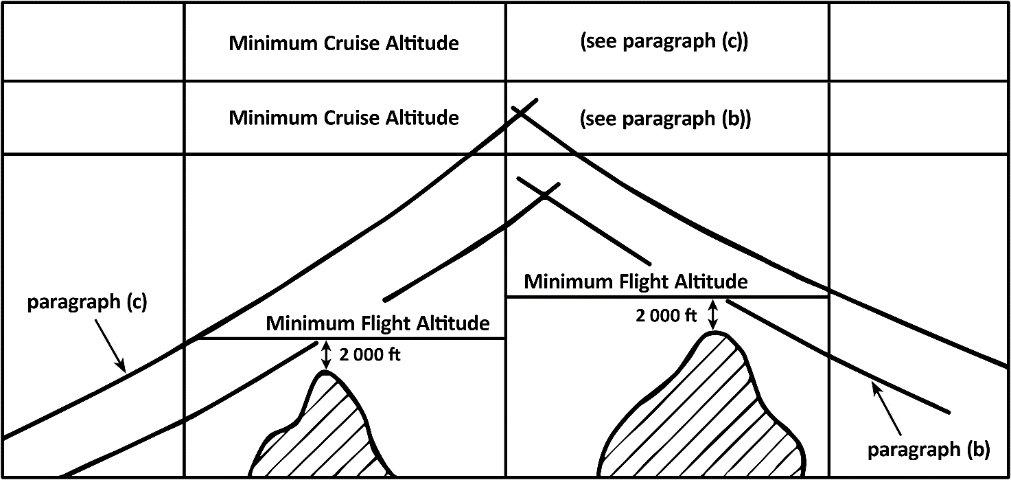 Note: MEA or MORA normally provide the required 2 000 ft obstacle clearance for drift down. However, at and below 6 000 ft altitude, MEA and MORA cannot be used directly as only 1 000 ft clearance is ensured.
AMC1 CAT.POL.A.215 En-route – one-engine-inoperative (OEI) ED Decision 2021/005/R ROUTE ANALYSIS (a) The high terrain or obstacle analysis required should be carried out by a detailed analysis of the route. (b) A detailed analysis of the route should be made using contour maps of the high terrain and plotting the highest points within the prescribed corridor’s width along the route. The next step is to determine whether it is possible to maintain level flight with OEI 1 000 ft above the highest point of the crossing. If this is not possible, or if the associated weight penalties are unacceptable, a drift down procedure should be worked out, based on engine failure at the most critical point and clearing critical obstacles during the drift down by at least 2 000 ft. The minimum cruise altitude is determined by the intersection of the two drift down paths, taking into account allowances for decision making (see Figure 1). This method is time-consuming and requires the availability of detailed terrain maps. (c) Alternatively, the published minimum flight altitudes (MEA or minimum off-route altitude (MORA)) should be used for determining whether OEI level flight is feasible at the minimum flight altitude, or if it is necessary to use the published minimum flight altitudes as the basis for the drift down construction (see Figure 1). This procedure avoids a detailed high terrain contour analysis, but could be more penalising than taking the actual terrain profile into account as in (b). (d) In order to comply with [CAT.POL.A.215](#_DxCrossRefBm318086350) (c), one means of compliance is the use of MORA and, with CAT.POL.A.215 (d), MEA provided that the aeroplane meets the navigational equipment standard assumed in the definition of MEA. Figure 1 Intersection of the two drift down paths 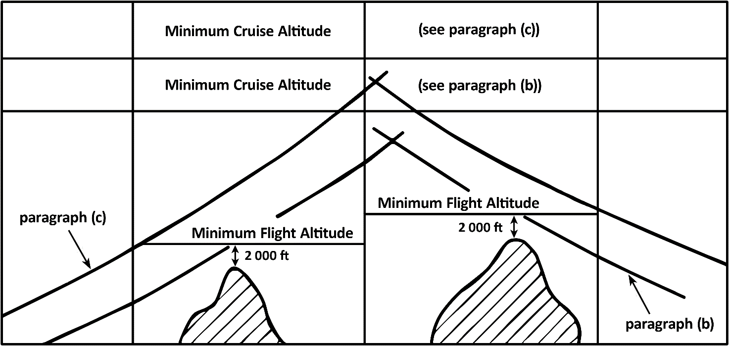 Note: MEA or MORA normally provide the required 2 000 ft obstacle clearance for drift down. However, at and below 6 000 ft altitude, MEA and MORA cannot be used directly as only 1 000 ft clearance is ensured.
##### AMC1 CAT.POL.A.215 En-route – one-engine-inoperative (OEI) *ED Decision 2021/005/R* **ROUTE ANALYSIS** (a) The high terrain or obstacle analysis required should be carried out by a detailed analysis of the route. (b) A detailed analysis of the route should be made using contour maps of the high terrain and plotting the highest points within the prescribed corridor’s width along the route. The next step is to determine whether it is possible to maintain level flight with OEI 1 000 ft above the highest point of the crossing. If this is not possible, or if the associated weight penalties are unacceptable, a drift down procedure should be worked out, based on engine failure at the most critical point and clearing critical obstacles during the drift down by at least 2 000 ft. The minimum cruise altitude is determined by the intersection of the two drift down paths, taking into account allowances for decision making (see Figure 1). This method is time-consuming and requires the availability of detailed terrain maps. (c) Alternatively, the published minimum flight altitudes (MEA or minimum off-route altitude (MORA)) should be used for determining whether OEI level flight is feasible at the minimum flight altitude, or if it is necessary to use the published minimum flight altitudes as the basis for the drift down construction (see Figure 1). This procedure avoids a detailed high terrain contour analysis, but could be more penalising than taking the actual terrain profile into account as in (b). (d) In order to comply with [CAT.POL.A.215](#_DxCrossRefBm523088286) (c), one means of compliance is the use of MORA and, with CAT.POL.A.215 (d), MEA provided that the aeroplane meets the navigational equipment standard assumed in the definition of MEA. ***Figure 1*** Intersection of the two drift down paths 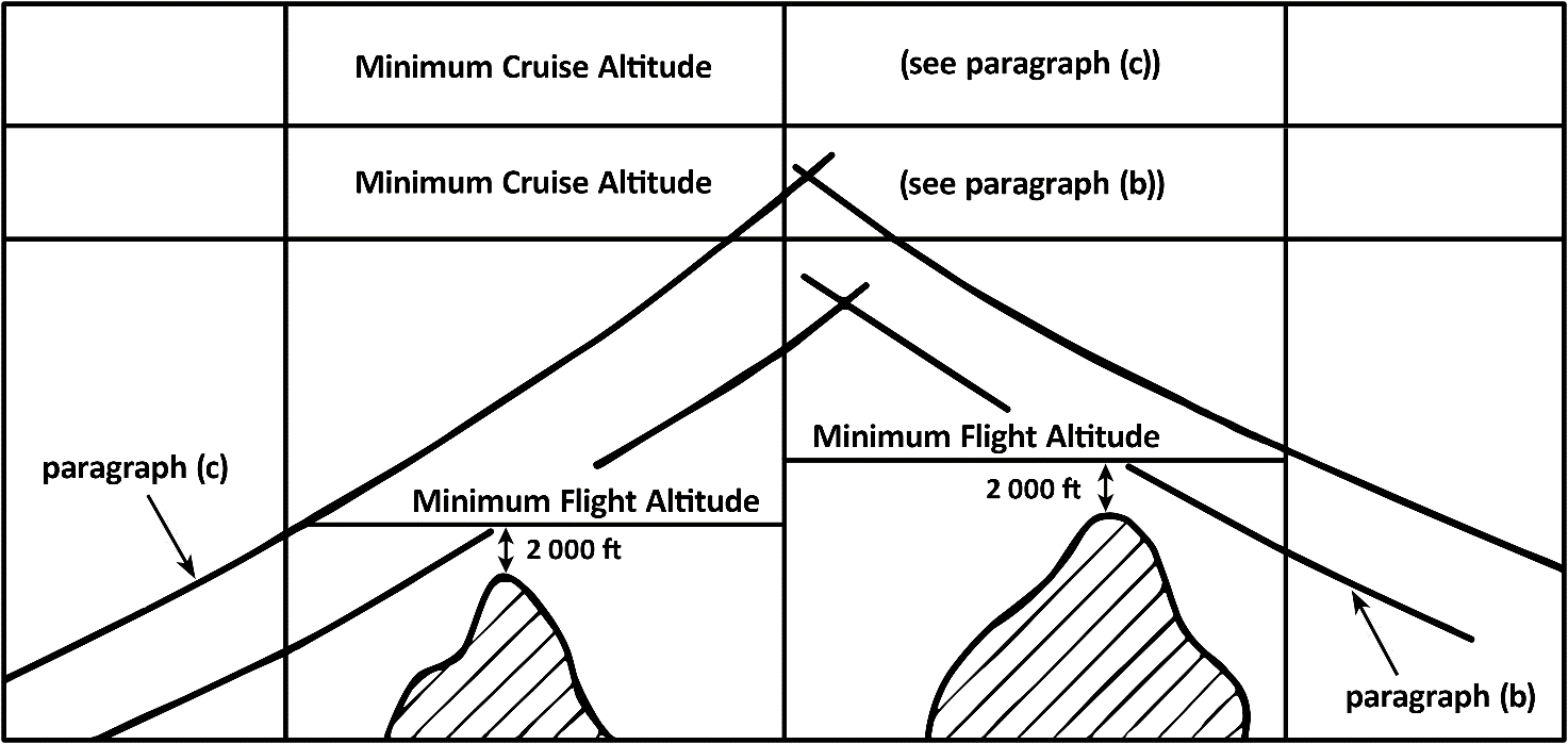 Note: MEA or MORA normally provide the required 2 000 ft obstacle clearance for drift down. However, at and below 6 000 ft altitude, MEA and MORA cannot be used directly as only 1 000 ft clearance is ensured.
Contact support