GM4 ADR.OPS.A.005(a) Aerodrome data
ED Decision 2014/012/R
COVERAGE AREAS FOR TERRAIN AND OBSTACLE DATA PROVISION
(a) The coverage areas for sets of electronic and obstacle data should be specified as follows:
(1) Area 1: the entire territory of the State;
(2) Area 2: within the aerodrome surroundings, sub-divided as follows:
(i) Area 2a: a rectangular area around a runway that comprises the runway strip plus any clearway that exists;
(ii) Area 2b: an area extending from the ends of Area 2a in the direction of departure, with a length of 10 km and a splay of 15 per cent to each side;
(iii) Area 2c: an area extending outside Area 2a and Area 2b at a distance of not more than 10 km from the boundary of Area 2a; and
(iv) Area 2d: an area outside the Areas 2a, 2b and 2c up to a distance of 45 km from the aerodrome reference point, or to an existing TMA boundary, whichever is nearest.
(3) Area 3: the area bordering an aerodrome movement area that extends horizontally from the edge of a runway to 90 m from the runway centre line, and 50 m from the edge of all other parts of the aerodrome movement area
(4) The area extending 900 m prior to the runway threshold, and 60 m each side of the extended runway centre line in the direction of the approach on a precision approach runway, Category II or III;
(b) A graphical representation of the terrain data collection surfaces for Areas 1 and 2 is shown in the following figure:
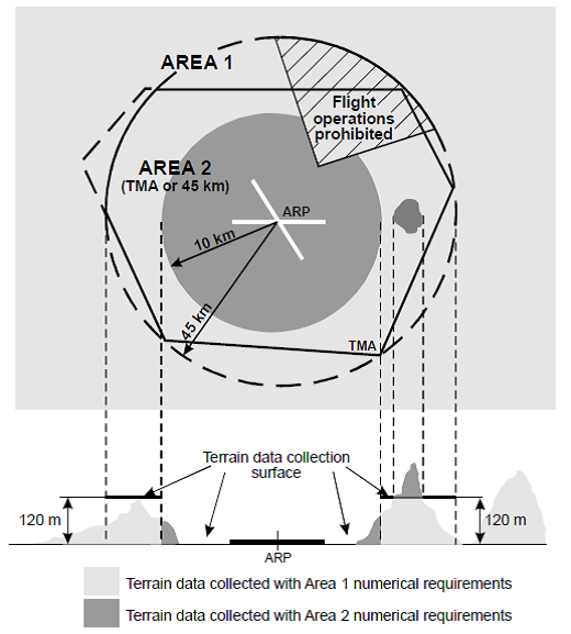
Figure 1 - Terrain data collection surfaces — Area 1 and Area 2
(1) Within the area covered by a 10-km radius from the ARP, terrain data should comply with the Area 2 numerical requirements;
(2) In the area between 10 km and the TMA boundary or 45-km radius (whichever is smaller), data on terrain that penetrates the horizontal plane 120 m above the lowest runway elevation, should comply with the Area 2 numerical requirements;
(3) In the area between 10 km and the TMA boundary or 45-km radius (whichever is smaller), data on terrain that does not penetrate the horizontal plane 120 m above the lowest runway elevation, should comply with the Area 1 numerical requirements;
(4) In those portions of Area 2 where flight operations are prohibited due to very high terrain or other local restrictions and/or regulations, terrain data should comply with the Area 1 numerical requirements.
(c) A graphical representation of the obstacle data collection surfaces for Areas 1 and 2 is shown in the following figure:
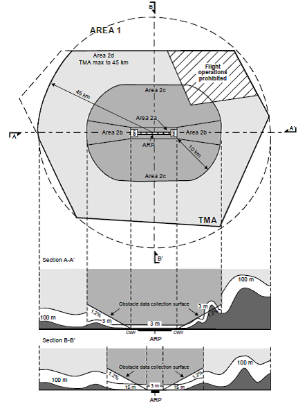
Figure 2 - Obstacle data collection surfaces — Area 1 and Area 2
(1) Obstacle data should be collected and recorded in accordance with the Area 2 numerical requirements;
(i) The Area 2a obstacle collection surface should have a height of 3 m above the nearest runway elevation measured along the runway centre line, and for those portions related to a clearway, if one exists, at the elevation of the nearest runway end;
(ii) The Area 2b obstacle collection surface has an 1.2 % slope extending from the ends of Area 2a at the elevation of the runway end in the direction of departure, with a length of 10 km and a splay of 15 % to each side;
(iii) The Area 2c collection surface has an 1.2 % slope extending outside Area 2a and Area 2b at a distance of not more than 10 km from the boundary of Area 2a. The initial elevation of Area 2c should be the elevation of the point of Area 2a at which it commences; and
(iv) The Area 2d obstacle collection surface has a height of 100 m above ground.
(2) In those portions of Area 2 where flight operations are prohibited due to very high terrain or other local restrictions and/or regulations, obstacle data should be collected and recorded in accordance with the Area 1 requirements;
(3) Data on every obstacle within Area 1 whose height above the ground is 100 m or higher should be collected and recorded in the database in accordance with the Area 1 numerical requirements specified in Table 2.
(d) A graphical representation of the terrain and obstacle data collection surfaces for Area 3 is shown in the following figure:
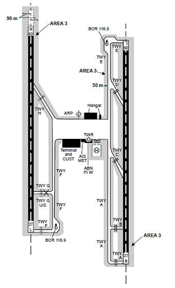
Figure 3 - Terrain and obstacle data collection surface — Area 3
(1) The data collection surface for terrain and obstacles extends a half metre (0.5 m) above the horizontal plane passing through the nearest point on the aerodrome movement area;
(2) Terrain and obstacle data in Area 3 should comply with the numerical requirements specified in Tables 1 and 2, respectively;
(e) A graphical representation of the obstacle data collection surfaces for Areas 4 is shown in the following figure:
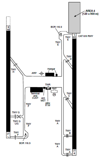
Figure 4 - Terrain and obstacle data collection surface — Area 4
(1) Terrain data in Area 4 should comply with the numerical requirements specified in Table 1;
(2) The horizontal extent of Area 2 covers Area 4. More detailed obstacle data may be collected in Area 4 in accordance with Area 4 numerical requirements for obstacle data specified in Table 2.
(3) Where the terrain at a distance greater than 900 m (3000 ft) from the runway threshold is mountainous or otherwise significant, the length of Area 4 should be extended to a distance not exceeding 2000 m (6500 ft) from the runway threshold.
|
Area 1 |
Area 2 |
Area 3 |
Area 4 |
Post spacing |
3 arc seconds (approx. 90 m) |
1 arc seconds (approx. 30 m) |
0.6 arc seconds (approx. 20 m) |
0.3 arc seconds (approx. 9 m) |
Vertical accuracy |
30 m |
3 m |
0.5 m |
1 m |
Vertical resolution |
1 m |
0.1 m |
0.01 m |
0.1 m |
Horizontal accuracy |
50 m |
5 m |
0.5 m |
2.5 m |
Confidence level |
90 % |
90 % |
90 % |
90 % |
Data classification Integrity level |
Routine |
Essential |
Essential |
Essential |
Maintenance period |
as required |
as required |
as required |
as required |
Table 1 - Terrain data numerical requirements
|
Area 1 |
Area 2 |
Area 3 |
Area 4 |
Vertical accuracy |
30 m |
3 m |
0.5 m |
1 m |
Vertical resolution |
1 m |
0.1 m |
0.01 m |
0.1 m |
Horizontal accuracy |
50 m |
5 m |
0.5 m |
2.5 m |
Confidence level |
90 % |
90 % |
90 % |
90 % |
Data classification Integrity level |
Routine |
Essential |
Essential |
Essential |
Maintenance period |
as required |
as required |
as required |
as required |
Table 2 - Obstacle data numerical requirements