AMC1 ATS.TR.210(c)(2)(ii) Operation of air traffic control service
ED Decision 2020/008/R
PROCEDURAL
CONTROL — LATERAL SEPARATION CRITERIA AND MINIMA
Lateral separation should be applied by one of the following means:
(a) By reference to the same or different geographic locations
By position reports which positively indicate that the aircraft are over different geographic locations as determined visually or by reference to a navigation aid (see Figure 38).
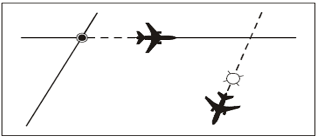
Figure 38: Using same or different geographic locations
(b) By use of NDB, VOR or GNSS on intersecting tracks or ATS routes
By requiring aircraft to fly on specified tracks which are separated by a minimum amount appropriate to the navigation aid employed. Lateral separation between two aircraft exists when:
(1) (VOR) both aircraft are established on radials diverging by at least 15 degrees and at least one aircraft is at a distance of 28 km (15 NM) or more from the facility (see Figure 39);
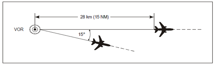
Figure 39: Separation using the same VOR
(2) (NDB) both aircraft are established on tracks to or from the NDB which are diverging by at least 30 degrees and at least one aircraft is at a distance of 28 km (15 NM) or more from the facility (see Figure 40);
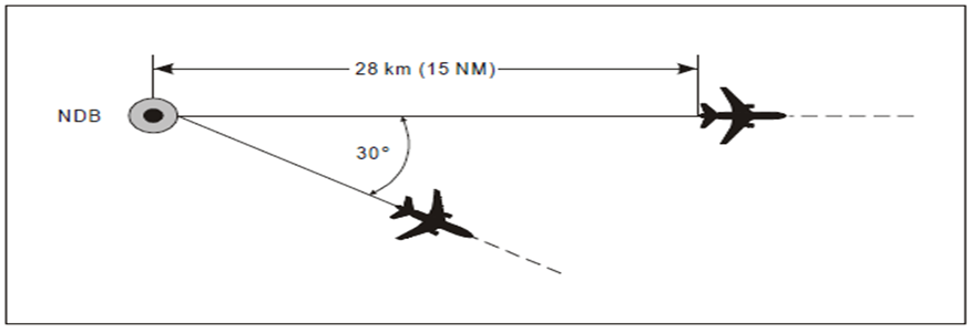
Figure 40: Separation using the same NDB
(3) (GNSS/GNSS) each aircraft is confirmed to be established on a track with zero offset between two waypoints and at least one aircraft is at a minimum distance from a common point as specified in Table 1 below; or
(4) (VOR/GNSS) the aircraft using VOR is established on a radial to or from the VOR and the other aircraft using GNSS is confirmed to be established on a track with zero offset between two waypoints and at least one aircraft is at a minimum distance from a common point as specified in the table below.
|
|
Aircraft
1: VOR or GNSS Aircraft
2: GNSS |
|
|
Angular difference between tracks measured at the common point |
FL010-FL090 Distance from a common point |
FL200-FL600 Distance from a common point |
|
15-135 |
27.8 km (15 NM) |
43 km (23 NM) |
|
The distances in the table are ground distances. States must take into account the distance (slant range) from the source of a DME signal to the receiving antenna when DME is being utilised to provide range information. |
||
(c) By use of different navigation aids or methods
Lateral separation between aircraft using different navigation aids, or when one aircraft is using RNAV equipment, should be established by ensuring that the derived protected airspaces for the navigation aid(s) or RNP do not overlap.
(d) Lateral separation of aircraft on published instrument flight procedures for arrivals and departures
Lateral separation of departing and/or arriving aircraft, using instrument flight procedures, will exist where:
(1) the distance between any combination of RNAV 1 with RNAV 1, or RNP 1, RNP APCH or RNP AR APCH tracks is not less than 13 km (7 NM); or
(2) the distance between any combination of RNP 1, RNP APCH or RNP AR APCH tracks is not less than 9.3 km (5 NM); or
(3) the protected areas of tracks designed using obstacle clearance criteria do not overlap and provided operational error is considered.
(e) RNAV operations where RNP is specified on parallel tracks or ATS routes
Within designated airspace or on designated routes, where RNP is specified, lateral separation between RNAV-equipped aircraft may be obtained by requiring aircraft to be established on the centre lines of parallel tracks or ATS routes spaced at a distance which ensures that the protected airspace of the tracks or ATS routes does not overlap.
(f) Transitioning into airspace where a greater lateral separation minimum applies
Lateral separation will exist when aircraft are established on specified tracks which:
(1) are separated by an appropriate minimum; and
(2) diverge by at least 15 degrees until the applicable lateral separation minimum is established,
provided that it is possible to ensure, by means approved by the competent authority, that aircraft have the navigation capability necessary to ensure accurate track guidance.