Light
Dark
System
Log In
Loading...
Compare / EASA/
Incorporated Amendments
/
Compare & Highlight Differences
Appendix 5a -- General guidelines
Available versions for ERULES-1963177438-3591
ED Decision 2020/020/R
found in: ATM/ANS Provision of Services (No 2017/373) (Feb 2023)
Select original version
...25)
...23)
Original Text
Select changed version
...25)
...23)
Changed text
Removed: 0
Added: 0
Unchanged: 0
Share
Appendix 5a — General guidelines ED Decision 2020/020/R SYLLABI STRUCTURE This guidance material provides explanatory material on how to read the tables in the appendices contained in Subpart A of the AMC & GM to Part-PERS. Four tables are provided: (a) Basic training — Shared (Appendix 1a); (b) Basic training — Streams (Appendix 2a); (c) Qualification training — Shared (Appendix 3a); and (d) Qualification training — Streams (Appendix 4a). The tables have the following structure: ![Aviation.Bot AI suggestion, not from EASA source: [Image caption skipped for debugging]](/static/files/file_gqs63YSDadR/image103.png) Figure 1: Structure of tables (a) Granularity table (Appendix 4a only) The granularity table indicates the stream(s) with which the objectives are associated. Where objectives are common to multiple streams, it is necessary to only include the objective once in the ATSEP training syllabus. (b) ATSEP unique objective identifier (UOID) This is a unique identifier for each objective. Where objectives are repeated across multiple streams, the UOID is linked to the parent domain. The structure of the UOID is the following: AREA.DOMAIN.SUBJECT\_topic#.subtopic#.objective# An example of a UOID decoding for ATSEP.QLF.SUR.PSR\_1.2.1: — ATSEP: fixed field that indicates the training area; — QLF.SUR.: phase of training (qualification) and domain (surveillance); — (Note: basic training uses only ‘BAS’ without a second field); — PSR: subject (primary surveillance radar); — \_1: topic number (PSR); — .2: subtopic number (antenna (PSR)); and — .1: objective number (1). (c) Training objectives Each training objective contains three mandatory elements: (1) Corpus A description of the required performance. It always contains an action verb at the beginning of the sentence to ensure that the outcome is observable. The action verb is always associated with a defined taxonomy. The tables at the end of this section list action verbs and their associated taxonomy levels. Those verbs and levels are used or may be used for training objectives. (2) Taxonomy Level A numerical representation of the classification of the action verb. (i) Level 1: basic knowledge of the subject. It is the ability to remember essential points, memorise data, and retrieve it. (ii) Level 2: the ability to understand and discuss the subject matter intelligently in order to describe and act on certain objects and events. (iii) Level 3: thorough knowledge of the subject and the ability to apply it with accuracy. The ability to make use of the repertoire of knowledge to develop plans and activate them. (iv) Level 4: the ability to establish a line of action within a unit of known applications by following the correct chronology and the adequate method to resolve a problem situation. This involves integrating known applications into a familiar situation. (v) Level 5: the ability to analyse new situations in order to elaborate and apply one or another relevant strategy to solve a complex problem. The defining feature is that the situation is qualitatively different to those previously met, requiring judgement and evaluation of options. The content illustrates and details performance. When the items are in a list, each of them is to be addressed as a minimum. ‘e.g.’ is used to indicate optional content. All content following ‘e.g.’ is provided to illustrate the type of content that could be used to meet the objective. When there is no mandatory content, the objective has to be performed according to the action verb. Where content refers to other documents (e.g. ICAO SARPs, EU regulations, etc.), users should take care to use the most recent version(s) of the referenced document(s) or its/their parts. (d) Domain The domain is indicated through white text on blue background. The following domains are defined: QLF.SHR SHARED (common part for all qualification domains); QLF.COM COMMUNICATION; QLF.NAV NAVIGATION; QLF.SUR SURVEILLANCE; QLF.DPR DATA PROCESSING; and QLF.SMC SYSTEM MONITORING AND CONTROL. In addition, basic training is also considered to be a domain in the tables: BAS BASIC. (e) Subject The subject is indicated through black text on dark grey background. A subject structures the domain into smaller elements. (f) Topic The topic is indicated through black text on mid grey background. A topic structures the subject into smaller elements. (g) Subtopic The subtopic is indicated through black text on light grey background. A subtopic structures the topic into smaller elements. (h) Action verbs The tables below list action verbs and their associated taxonomy levels that are used in training objectives. Definition of verbs — Level 1 <table border="1" cellpadding="0" cellspacing="0" width="605"> <tr> <td valign="top" width="102"> <p><b>Verb</b></p> </td> <td valign="top" width="251"> <p><b>Definition</b></p> </td> <td valign="top" width="251"> <p><b>Example</b></p> </td> </tr> <tr> <td valign="top" width="102"> <p><b>Define</b></p> </td> <td valign="top" width="251"> <p>State what it is and what its limits are; state the definition.</p> </td> <td valign="top" width="251"> <p>Define airborne safety nets.</p> </td> </tr> <tr> <td valign="top" width="102"> <p><b>Draw</b></p> </td> <td valign="top" width="251"> <p>Produce a picture, pattern, or diagram.</p> </td> <td valign="top" width="251"> <p>Draw the MLAT system architecture.</p> </td> </tr> <tr> <td valign="top" width="102"> <p><b>List</b></p> </td> <td valign="top" width="251"> <p>Say one after the other.</p> </td> <td valign="top" width="251"> <p>List the most common weather messages.</p> </td> </tr> <tr> <td valign="top" width="102"> <p><b>Name</b></p> </td> <td valign="top" width="251"> <p>Give the name of objects or procedures.</p> </td> <td valign="top" width="251"> <p>Name a range of air-ground aviation-related network concepts.</p> </td> </tr> <tr> <td valign="top" width="102"> <p><b>Recognise</b></p> </td> <td valign="top" width="251"> <p>Know what it is, because you have seen it before.</p> </td> <td valign="top" width="251"> <p>Recognise surveillance information on a display.</p> </td> </tr> <tr> <td valign="top" width="102"> <p><b>State</b></p> </td> <td valign="top" width="251"> <p>Say or write in a formal or definite way.</p> </td> <td valign="top" width="251"> <p>State the function of a network management system.</p> </td> </tr> </table> Definition of verbs — Level 2 <table border="1" cellpadding="0" cellspacing="0" width="605"> <tr> <td valign="top" width="103"> <p><b>Verb</b></p> </td> <td valign="top" width="250"> <p><b>Definition</b></p> </td> <td valign="top" width="252"> <p><b>Example</b></p> </td> </tr> <tr> <td valign="top" width="103"> <p><b>Characterise</b></p> </td> <td valign="top" width="250"> <p>Describe the quality of features in something.</p> </td> <td valign="top" width="252"> <p>Characterise navigation methods.</p> </td> </tr> <tr> <td valign="top" width="103"> <p><b>Consider</b></p> </td> <td valign="top" width="250"> <p>Think carefully about it.</p> </td> <td valign="top" width="252"> <p>Consider the benefits of Critical Incident Stress Management (CISM).</p> </td> </tr> <tr> <td valign="top" width="103"> <p><b>Demonstrate</b></p> </td> <td valign="top" width="250"> <p>Describe and explain. Logically or mathematically, prove the truth of the statement.</p> </td> <td valign="top" width="252"> <p>Demonstrate the use of middleware in an ATM environment.</p> </td> </tr> <tr> <td valign="top" width="103"> <p><b>Describe</b></p> </td> <td valign="top" width="250"> <p>Say what it is like or what happened.</p> </td> <td valign="top" width="252"> <p>Describe the elements of Global Navigation Satellite System (GNSS) in Europe.</p> </td> </tr> <tr> <td valign="top" width="103"> <p><b>Differentiate</b></p> </td> <td valign="top" width="250"> <p>Show the difference between things.</p> </td> <td valign="top" width="252"> <p>Differentiate conventional navigation from area navigation.</p> </td> </tr> <tr> <td valign="top" width="103"> <p><b>Explain</b></p> </td> <td valign="top" width="250"> <p>Give details about something or describe so that it can be understood.</p> </td> <td valign="top" width="252"> <p>Explain the function of FDP.</p> </td> </tr> <tr> <td valign="top" width="103"> <p><b>Take account of</b></p> </td> <td valign="top" width="250"> <p>Take into consideration before deciding.</p> </td> <td valign="top" width="252"> <p>Take account of hardware/software compatibility.</p> </td> </tr> </table> Definition of verbs — Level 3 <table border="1" cellpadding="0" cellspacing="0" width="605"> <thead> <tr> <td valign="top" width="103"> <p><b>Verb</b></p> </td> <td valign="top" width="250"> <p><b>Definition</b></p> </td> <td valign="top" width="252"> <p><b>Example</b></p> </td> </tr> </thead> <tr> <td valign="top" width="103"> <p><b>Apply</b></p> </td> <td valign="top" width="250"> <p>Use something in a situation or activity.</p> </td> <td valign="top" width="252"> <p>Apply the principles of layers.</p> </td> </tr> <tr> <td valign="top" width="103"> <p><b>Appreciate</b></p> </td> <td valign="top" width="250"> <p>Understand a situation and know what is involved in a problem-solving situation, to state a plan without applying it.</p> </td> <td valign="top" width="252"> <p>Appreciate how to troubleshoot a network.</p> </td> </tr> <tr> <td valign="top" width="103"> <p><b>Calculate</b></p> </td> <td valign="top" width="250"> <p>Discover from information you already have by arithmetic; to think about a possible cause of action in order to form an opinion or decide what to do.</p> </td> <td valign="top" width="252"> <p>Calculate parameters of a line.</p> </td> </tr> <tr> <td valign="top" width="103"> <p><b>Check</b></p> </td> <td valign="top" width="250"> <p>Make sure the information is correct (satisfactory).</p> </td> <td valign="top" width="252"> <p>Check the conformity of a system to ITU and national regulation.</p> </td> </tr> <tr> <td valign="top" width="103"> <p><b>Decode</b></p> </td> <td valign="top" width="250"> <p>Turn into ordinary writing, decipher.</p> </td> <td valign="top" width="252"> <p>Decode a typical OLDI message.</p> </td> </tr> <tr> <td valign="top" width="103"> <p><b>Estimate</b></p> </td> <td valign="top" width="250"> <p>Form an approximate judgement of a number, form an opinion.</p> </td> <td valign="top" width="252"> <p>Estimate the impact of security and integrity failure to the operational service.</p> </td> </tr> <tr> <td valign="top" width="103"> <p><b>Identify</b></p> </td> <td valign="top" width="250"> <p>Associate oneself inseparably with, establish the identity.</p> </td> <td valign="top" width="252"> <p>Identify the major elements of the ADS-C system.</p> </td> </tr> <tr> <td valign="top" width="103"> <p><b>Operate</b></p> </td> <td valign="top" width="250"> <p>Conduct work on equipment.</p> </td> <td valign="top" width="252"> <p>Operate measuring equipment.</p> </td> </tr> <tr> <td valign="top" width="103"> <p><b>Perform</b></p> </td> <td valign="top" width="250"> <p>Carry into effect, go through, execute.</p> </td> <td valign="top" width="252"> <p>Perform measurements with generic radio test equipment.</p> </td> </tr> <tr> <td valign="top" width="103"> <p><b>Use</b></p> </td> <td valign="top" width="250"> <p>Employ for a purpose, handle as instrument, put into operation.</p> </td> <td valign="top" width="252"> <p>Use appropriate vocabulary to communicate effectively on technical matters.</p> </td> </tr> </table> Definition of verbs — Level 4 <table border="1" cellpadding="0" cellspacing="0" width="605"> <tr> <td valign="top" width="103"> <p><b>Verb</b></p> </td> <td valign="top" width="250"> <p><b>Definition</b></p> </td> <td valign="top" width="252"> <p><b>Example</b></p> </td> </tr> <tr> <td valign="top" width="103"> <p><b>Adjust</b></p> </td> <td valign="top" width="250"> <p>Change to a new position, value or setting.</p> </td> <td valign="top" width="252"> <p>Adjust a generic radio receiver.</p> </td> </tr> <tr> <td valign="top" width="103"> <p><b>Analyse</b></p> </td> <td valign="top" width="250"> <p>Examine minutely the constitution of. </p> </td> <td valign="top" width="252"> <p>Analyse the block diagram of a generic radio receiver.</p> </td> </tr> <tr> <td valign="top" width="103"> <p><b>Justify</b></p> </td> <td valign="top" width="250"> <p>Show the rightness of a choice or of an option.</p> </td> <td valign="top" width="252"> <p>Justify the occasions when it is necessary to downgrade an ILS facility performance category.</p> </td> </tr> <tr> <td valign="top" width="103"> <p><b>Relate</b></p> </td> <td valign="top" width="250"> <p>Establish link with.</p> </td> <td valign="top" width="252"> <p>Relate VOR station design to operational requirement.</p> </td> </tr> </table> Definition of verbs — Level 5 <table border="1" cellpadding="0" cellspacing="0" width="605"> <tr> <td valign="top" width="103"> <p><b>Verb</b></p> </td> <td valign="top" width="250"> <p><b>Definition</b></p> </td> <td valign="top" width="252"> <p><b>Example</b></p> </td> </tr> <tr> <td valign="top" width="103"> <p><b>Interpret</b></p> </td> <td valign="top" width="250"> <p>Decide on the meaning or significance of something when there is a choice.</p> </td> <td valign="top" width="252"> <p>Interpret ILS facility performance categories.</p> </td> </tr> </table> (i) Acronyms The following abbreviations are used in the tables: <table border="1" cellpadding="0" cellspacing="0" width="604"> <tr> <td valign="top" width="110"> <p><b>AAIM</b></p> </td> <td valign="top" width="495"> <p>Aircraft Autonomous Integrity Monitoring</p> </td> </tr> <tr> <td valign="top" width="110"> <p><b>ABAS</b></p> </td> <td valign="top" width="495"> <p>Aircraft-Based Augmentation System</p> </td> </tr> <tr> <td valign="top" width="110"> <p><b>ACARS</b></p> </td> <td valign="top" width="495"> <p>Aircraft Communications Addressing and Reporting System</p> </td> </tr> <tr> <td valign="top" width="110"> <p><b>ACAS</b></p> </td> <td valign="top" width="495"> <p>Airborne Collision Avoidance System</p> </td> </tr> <tr> <td valign="top" width="110"> <p><b>ACC</b></p> </td> <td valign="top" width="495"> <p>Area Control Centre</p> </td> </tr> <tr> <td valign="top" width="110"> <p><b>A/D</b></p> </td> <td valign="top" width="495"> <p>Analogue/Digital</p> </td> </tr> <tr> <td valign="top" width="110"> <p><b>ADEX-P</b></p> </td> <td valign="top" width="495"> <p>ATS Data Exchange Presentation</p> </td> </tr> <tr> <td valign="top" width="110"> <p><b>ADS</b></p> </td> <td valign="top" width="495"> <p>Automatic Dependent Surveillance</p> </td> </tr> <tr> <td valign="top" width="110"> <p><b>ADS B</b></p> </td> <td valign="top" width="495"> <p>ADS — Broadcast</p> </td> </tr> <tr> <td valign="top" width="110"> <p><b>ADS C</b></p> </td> <td valign="top" width="495"> <p>ADS — Contract</p> </td> </tr> <tr> <td valign="top" width="110"> <p><b>ADF</b></p> </td> <td valign="top" width="495"> <p>Automatic Direction Finder</p> </td> </tr> <tr> <td valign="top" width="110"> <p><b>AFDX</b></p> </td> <td valign="top" width="495"> <p>Avionics Full-duplex Ethernet Switch</p> </td> </tr> <tr> <td valign="top" width="110"> <p><b>AFTN</b></p> </td> <td valign="top" width="495"> <p>Aeronautical Fixed Telecommunications Network</p> </td> </tr> <tr> <td valign="top" width="110"> <p><b>AGC</b></p> </td> <td valign="top" width="495"> <p>Automatic Gain Control</p> </td> </tr> <tr> <td valign="top" width="110"> <p><b>AIC</b></p> </td> <td valign="top" width="495"> <p>Aeronautical Information Circular</p> </td> </tr> <tr> <td valign="top" width="110"> <p><b>AIDC</b></p> </td> <td valign="top" width="495"> <p>ATS Interfacility Data Communications</p> </td> </tr> <tr> <td valign="top" width="110"> <p><b>AIP</b></p> </td> <td valign="top" width="495"> <p>Aeronautical Information Publication</p> </td> </tr> <tr> <td valign="top" width="110"> <p><b>AIRAC</b></p> </td> <td valign="top" width="495"> <p>Aeronautical Information Regulation and Control</p> </td> </tr> <tr> <td valign="top" width="110"> <p><b>AIS</b></p> </td> <td valign="top" width="495"> <p>Aeronautical Information Services</p> </td> </tr> <tr> <td valign="top" width="110"> <p><b>ALARP</b></p> </td> <td valign="top" width="495"> <p>As Low As Reasonably Practicable</p> </td> </tr> <tr> <td valign="top" width="110"> <p><b>AMAN</b></p> </td> <td valign="top" width="495"> <p>Arrival Manager</p> </td> </tr> <tr> <td valign="top" width="110"> <p><b>AMHS</b></p> </td> <td valign="top" width="495"> <p>Aeronautical Message Handling System</p> </td> </tr> <tr> <td valign="top" width="110"> <p><b>AMSS</b></p> </td> <td valign="top" width="495"> <p>Automatic Message Switching System</p> </td> </tr> <tr> <td valign="top" width="110"> <p><b>ANS</b></p> </td> <td valign="top" width="495"> <p>Air Navigation Services</p> </td> </tr> <tr> <td valign="top" width="110"> <p><b>ANSP</b></p> </td> <td valign="top" width="495"> <p>ANS Provider</p> </td> </tr> <tr> <td valign="top" width="110"> <p><b>APV</b></p> </td> <td valign="top" width="495"> <p>Approach Procedure with Vertical guidance</p> </td> </tr> <tr> <td valign="top" width="110"> <p><b>APW</b></p> </td> <td valign="top" width="495"> <p>Area Proximity Warning</p> </td> </tr> <tr> <td valign="top" width="110"> <p><b>ARINC</b></p> </td> <td valign="top" width="495"> <p>Aeronautical Radio Incorporated</p> </td> </tr> <tr> <td valign="top" width="110"> <p><b>ARTAS</b></p> </td> <td valign="top" width="495"> <p>ATC Radar Tracker and Server</p> </td> </tr> <tr> <td valign="top" width="110"> <p><b>ASAS</b></p> </td> <td valign="top" width="495"> <p>Airborne Separation Assistance/Assurance System</p> </td> </tr> <tr> <td valign="top" width="110"> <p><b>ASM</b></p> </td> <td valign="top" width="495"> <p>Airspace Management</p> </td> </tr> <tr> <td valign="top" width="110"> <p><b>ASMGCS</b></p> </td> <td valign="top" width="495"> <p>Advanced SMGCS</p> </td> </tr> <tr> <td valign="top" width="110"> <p><b>ASTERIX</b></p> </td> <td valign="top" width="495"> <p>All-purpose Structured EUROCONTROL Radar Information Exchange</p> </td> </tr> <tr> <td valign="top" width="110"> <p><b>ATC</b></p> </td> <td valign="top" width="495"> <p>Air Traffic Control</p> </td> </tr> <tr> <td valign="top" width="110"> <p><b>ATFCM</b></p> </td> <td valign="top" width="495"> <p>Air Traffic Flow and Capacity Management</p> </td> </tr> <tr> <td valign="top" width="110"> <p><b>ATIS</b></p> </td> <td valign="top" width="495"> <p>Automatic Terminal Information Service</p> </td> </tr> <tr> <td valign="top" width="110"> <p><b>ATM</b></p> </td> <td valign="top" width="495"> <p>Air Traffic Management</p> </td> </tr> <tr> <td valign="top" width="110"> <p><b>ATN</b></p> </td> <td valign="top" width="495"> <p>Aeronautical Telecommunication Network</p> </td> </tr> <tr> <td valign="top" width="110"> <p><b>ATS</b></p> </td> <td valign="top" width="495"> <p>Air Traffic Services</p> </td> </tr> <tr> <td valign="top" width="110"> <p><b>ATSEP</b></p> </td> <td valign="top" width="495"> <p>Air Traffic Safety Electronics Personnel</p> </td> </tr> <tr> <td valign="top" width="110"> <p><b>AUGUR</b></p> </td> <td valign="top" width="495"> <p>EUROCONTROL RAIM Prediction Tool</p> </td> </tr> <tr> <td valign="top" width="110"> <p><b>BATAP</b></p> </td> <td valign="top" width="495"> <p>‘Type-B’ Application-to-Application Protocol</p> </td> </tr> <tr> <td valign="top" width="110"> <p><b>BDS</b></p> </td> <td valign="top" width="495"> <p>Binary Data Store</p> </td> </tr> <tr> <td valign="top" width="110"> <p><b>BER</b></p> </td> <td valign="top" width="495"> <p>Bit Error Rate</p> </td> </tr> <tr> <td valign="top" width="110"> <p><b>BITE</b></p> </td> <td valign="top" width="495"> <p>Built-In Test Equipment</p> </td> </tr> <tr> <td valign="top" width="110"> <p><b>B-RNAV</b></p> </td> <td valign="top" width="495"> <p>Basic-RNAV</p> </td> </tr> <tr> <td valign="top" width="110"> <p><b>CAA</b></p> </td> <td valign="top" width="495"> <p>Civil Aviation Authority</p> </td> </tr> <tr> <td valign="top" width="110"> <p><b>CB</b></p> </td> <td valign="top" width="495"> <p>Cumulonimbus</p> </td> </tr> <tr> <td valign="top" width="110"> <p><b>CBT</b></p> </td> <td valign="top" width="495"> <p>Computer-Based Training</p> </td> </tr> <tr> <td valign="top" width="110"> <p><b>CDM</b></p> </td> <td valign="top" width="495"> <p>Collaborative Decision-Making</p> </td> </tr> <tr> <td valign="top" width="110"> <p><b>CDTI</b></p> </td> <td valign="top" width="495"> <p>Cockpit Display of Traffic Information</p> </td> </tr> <tr> <td valign="top" width="110"> <p><b>CFMU</b></p> </td> <td valign="top" width="495"> <p>Central Flow Management Unit</p> </td> </tr> <tr> <td valign="top" width="110"> <p><b>CIDIN</b></p> </td> <td valign="top" width="495"> <p>Common ICAO Data Interchange Network</p> </td> </tr> <tr> <td valign="top" width="110"> <p><b>CISM</b></p> </td> <td valign="top" width="495"> <p>Critical Incident Stress Management</p> </td> </tr> <tr> <td valign="top" width="110"> <p><b>CIV</b></p> </td> <td valign="top" width="495"> <p>Civil</p> </td> </tr> <tr> <td valign="top" width="110"> <p><b>CLAM</b></p> </td> <td valign="top" width="495"> <p>Cleared flight Level Adherence Monitoring</p> </td> </tr> <tr> <td valign="top" width="110"> <p><b>CLIMAX</b></p> </td> <td valign="top" width="495"> <p>Multi-station carrier offset mode, with voting override</p> </td> </tr> <tr> <td valign="top" width="110"> <p><b>CMS</b></p> </td> <td valign="top" width="495"> <p>Control and Monitoring System</p> </td> </tr> <tr> <td valign="top" width="110"> <p><b>CNS/ATM</b></p> </td> <td valign="top" width="495"> <p>Communication Navigation and Surveillance/Air Traffic Management</p> </td> </tr> <tr> <td valign="top" width="110"> <p><b>CORA</b></p> </td> <td valign="top" width="495"> <p>Conflict Resolution Advisory</p> </td> </tr> <tr> <td valign="top" width="110"> <p><b>CORBA</b></p> </td> <td valign="top" width="495"> <p>Common Object Request Broker Architecture</p> </td> </tr> <tr> <td valign="top" width="110"> <p><b>COTS</b></p> </td> <td valign="top" width="495"> <p>Commercial off-the-Shelf</p> </td> </tr> <tr> <td valign="top" width="110"> <p><b>CPDLC</b></p> </td> <td valign="top" width="495"> <p>Controller-Pilot Data Link Communications</p> </td> </tr> <tr> <td valign="top" width="110"> <p><b>CRT</b></p> </td> <td valign="top" width="495"> <p>Cathode Ray Tube</p> </td> </tr> <tr> <td valign="top" width="110"> <p><b>CSU</b></p> </td> <td valign="top" width="495"> <p>Control Sector Unit</p> </td> </tr> <tr> <td valign="top" width="110"> <p><b>CTR</b></p> </td> <td valign="top" width="495"> <p>Control Zone</p> </td> </tr> <tr> <td valign="top" width="110"> <p><b>CVOR</b></p> </td> <td valign="top" width="495"> <p>Conventional VOR</p> </td> </tr> <tr> <td valign="top" width="110"> <p><b>CWP</b></p> </td> <td valign="top" width="495"> <p>Controller Work Position</p> </td> </tr> <tr> <td valign="top" width="110"> <p><b>DCL</b></p> </td> <td valign="top" width="495"> <p>Departure Clearance</p> </td> </tr> <tr> <td valign="top" width="110"> <p><b>DDF</b></p> </td> <td valign="top" width="495"> <p>Doppler DF</p> </td> </tr> <tr> <td valign="top" width="110"> <p><b>DDM</b></p> </td> <td valign="top" width="495"> <p>Difference of Depth of Modulation</p> </td> </tr> <tr> <td valign="top" width="110"> <p><b>DF</b></p> </td> <td valign="top" width="495"> <p>Direction Finding</p> </td> </tr> <tr> <td valign="top" width="110"> <p><b>DLIC</b></p> </td> <td valign="top" width="495"> <p>Data Link Initiation Capability</p> </td> </tr> <tr> <td valign="top" width="110"> <p><b>DMAN</b></p> </td> <td valign="top" width="495"> <p>Departure Manager</p> </td> </tr> <tr> <td valign="top" width="110"> <p><b>DME</b></p> </td> <td valign="top" width="495"> <p>Distance Measuring Equipment</p> </td> </tr> <tr> <td valign="top" width="110"> <p><b>DPSK</b></p> </td> <td valign="top" width="495"> <p>Differential Phase Shift Keying</p> </td> </tr> <tr> <td valign="top" width="110"> <p><b>DTMF</b></p> </td> <td valign="top" width="495"> <p>Dual Tone Modulation-Frequency</p> </td> </tr> <tr> <td valign="top" width="110"> <p><b>DVOR</b></p> </td> <td valign="top" width="495"> <p>Doppler VOR</p> </td> </tr> <tr> <td valign="top" width="110"> <p><b>EAD</b></p> </td> <td valign="top" width="495"> <p>European Aeronautical Database</p> </td> </tr> <tr> <td valign="top" width="110"> <p><b>EAN</b></p> </td> <td valign="top" width="495"> <p>European ANSP Network</p> </td> </tr> <tr> <td valign="top" width="110"> <p><b>EASA</b></p> </td> <td valign="top" width="495"> <p>European Aviation Safety Agency</p> </td> </tr> <tr> <td valign="top" width="110"> <p><b>ECAC</b></p> </td> <td valign="top" width="495"> <p>European Civil Aviation Conference</p> </td> </tr> <tr> <td valign="top" width="110"> <p><b>EFQM</b></p> </td> <td valign="top" width="495"> <p>European Foundation for Quality Management</p> </td> </tr> <tr> <td valign="top" width="110"> <p><b>EGNOS</b></p> </td> <td valign="top" width="495"> <p>European Geostationary Navigation Overlay Service</p> </td> </tr> <tr> <td valign="top" width="110"> <p><b>EGPWS</b></p> </td> <td valign="top" width="495"> <p>Enhanced Ground Proximity Warning System</p> </td> </tr> <tr> <td valign="top" width="110"> <p><b>EHS</b></p> </td> <td valign="top" width="495"> <p>Enhanced Mode S</p> </td> </tr> <tr> <td valign="top" width="110"> <p><b>EHT</b></p> </td> <td valign="top" width="495"> <p>Extremely High Tension</p> </td> </tr> <tr> <td valign="top" width="110"> <p><b>EJB</b></p> </td> <td valign="top" width="495"> <p>Enterprise Java Bean</p> </td> </tr> <tr> <td valign="top" width="110"> <p><b>ELS</b></p> </td> <td valign="top" width="495"> <p>Elementary Mode S</p> </td> </tr> <tr> <td valign="top" width="110"> <p><b>EMC</b></p> </td> <td valign="top" width="495"> <p>Electromagnetic Compatibility</p> </td> </tr> <tr> <td valign="top" width="110"> <p><b>EMI</b></p> </td> <td valign="top" width="495"> <p>Electromagnetic Interference</p> </td> </tr> <tr> <td valign="top" width="110"> <p><b>ETFMS</b></p> </td> <td valign="top" width="495"> <p>Enhanced Tactical FMS</p> </td> </tr> <tr> <td valign="top" width="110"> <p><b>EU</b></p> </td> <td valign="top" width="495"> <p>European Union</p> </td> </tr> <tr> <td valign="top" width="110"> <p><b>EUROCAE</b></p> </td> <td valign="top" width="495"> <p>European Civil Aviation Electronics</p> </td> </tr> <tr> <td valign="top" width="110"> <p><b>EUROCONTROL</b></p> </td> <td valign="top" width="495"> <p>European Organisation for the Safety of Air Navigation</p> </td> </tr> <tr> <td valign="top" width="110"> <p><b>FAA</b></p> </td> <td valign="top" width="495"> <p>Federal Aviation Administration (US)</p> </td> </tr> <tr> <td valign="top" width="110"> <p><b>FANS</b></p> </td> <td valign="top" width="495"> <p>Future Air Navigation Systems</p> </td> </tr> <tr> <td valign="top" width="110"> <p><b>FDP</b></p> </td> <td valign="top" width="495"> <p>Flight Data Processing</p> </td> </tr> <tr> <td valign="top" width="110"> <p><b>FDPS</b></p> </td> <td valign="top" width="495"> <p>FDP System</p> </td> </tr> <tr> <td valign="top" width="110"> <p><b>FFM</b></p> </td> <td valign="top" width="495"> <p>Far Field Monitor</p> </td> </tr> <tr> <td valign="top" width="110"> <p><b>FHA</b></p> </td> <td valign="top" width="495"> <p>Functional Hazard Assessment</p> </td> </tr> <tr> <td valign="top" width="110"> <p><b>FIR</b></p> </td> <td valign="top" width="495"> <p>Flight Information Region</p> </td> </tr> <tr> <td valign="top" width="110"> <p><b>FMS</b></p> </td> <td valign="top" width="495"> <p>Flight Management System</p> </td> </tr> <tr> <td valign="top" width="110"> <p><b>FMTP</b></p> </td> <td valign="top" width="495"> <p>Flight Plan Messaging Transport Protocol</p> </td> </tr> <tr> <td valign="top" width="110"> <p><b>FoM</b></p> </td> <td valign="top" width="495"> <p>Figures of Merit</p> </td> </tr> <tr> <td valign="top" width="110"> <p><b>FPL</b></p> </td> <td valign="top" width="495"> <p>(Filed) Flight Plan</p> </td> </tr> <tr> <td valign="top" width="110"> <p><b>FRUIT</b></p> </td> <td valign="top" width="495"> <p>False Reply Unsynchronised in Time</p> </td> </tr> <tr> <td valign="top" width="110"> <p><b>FUA</b></p> </td> <td valign="top" width="495"> <p>Flexible Use of Airspace</p> </td> </tr> <tr> <td valign="top" width="110"> <p><b>GALILEO</b></p> </td> <td valign="top" width="495"> <p>Satellite radio navigation system</p> </td> </tr> <tr> <td valign="top" width="110"> <p><b>GBAS</b></p> </td> <td valign="top" width="495"> <p>Ground-Based Augmentation System</p> </td> </tr> <tr> <td valign="top" width="110"> <p><b>GLONASS</b></p> </td> <td valign="top" width="495"> <p>GLObal’naya NAvigatsionnaya Sputnikovaya Sistema (Global Navigation Satellite System)</p> </td> </tr> <tr> <td valign="top" width="110"> <p><b>GNSS</b></p> </td> <td valign="top" width="495"> <p>Global Navigation Satellite System</p> </td> </tr> <tr> <td valign="top" width="110"> <p><b>GP</b></p> </td> <td valign="top" width="495"> <p>Glide Path</p> </td> </tr> <tr> <td valign="top" width="110"> <p><b>GPS</b></p> </td> <td valign="top" width="495"> <p>Global Positioning System</p> </td> </tr> <tr> <td valign="top" width="110"> <p><b>GRAS</b></p> </td> <td valign="top" width="495"> <p>Ground-based Regional Augmentation System</p> </td> </tr> <tr> <td valign="top" width="110"> <p><b>GSA</b></p> </td> <td valign="top" width="495"> <p>GNSS Supervisory Authority</p> </td> </tr> <tr> <td valign="top" width="110"> <p><b>GTC</b></p> </td> <td valign="top" width="495"> <p>Gain/Time Control</p> </td> </tr> <tr> <td valign="top" width="110"> <p><b>HF</b></p> </td> <td valign="top" width="495"> <p>High Frequency</p> </td> </tr> <tr> <td valign="top" width="110"> <p><b>HFDL</b></p> </td> <td valign="top" width="495"> <p>High Frequency Data Link</p> </td> </tr> <tr> <td valign="top" width="110"> <p><b>HMI</b></p> </td> <td valign="top" width="495"> <p>Human-Machine Interface</p> </td> </tr> <tr> <td valign="top" width="110"> <p><b>HPA</b></p> </td> <td valign="top" width="495"> <p>High Power Amplifier</p> </td> </tr> <tr> <td valign="top" width="110"> <p><b>HSI</b></p> </td> <td valign="top" width="495"> <p>Horizontal Situation Indication</p> </td> </tr> <tr> <td valign="top" width="110"> <p><b>HV</b></p> </td> <td valign="top" width="495"> <p>High Voltage</p> </td> </tr> <tr> <td valign="top" width="110"> <p><b>HW</b></p> </td> <td valign="top" width="495"> <p>Hardware</p> </td> </tr> <tr> <td valign="top" width="110"> <p><b>Hz</b></p> </td> <td valign="top" width="495"> <p>Hertz</p> </td> </tr> <tr> <td valign="top" width="110"> <p><b>ICAO</b></p> </td> <td valign="top" width="495"> <p>International Civil Aviation Organization</p> </td> </tr> <tr> <td valign="top" width="110"> <p><b>IDF</b></p> </td> <td valign="top" width="495"> <p>Interferometric DF</p> </td> </tr> <tr> <td valign="top" width="110"> <p><b>IF</b></p> </td> <td valign="top" width="495"> <p>Intermediate Frequency</p> </td> </tr> <tr> <td valign="top" width="110"> <p><b>IFF</b></p> </td> <td valign="top" width="495"> <p>Identification Friend/Foe</p> </td> </tr> <tr> <td valign="top" width="110"> <p><b>IFPS</b></p> </td> <td valign="top" width="495"> <p>(Integrated) Initial Flight Plan Processing System</p> </td> </tr> <tr> <td valign="top" width="110"> <p><b>ILS</b></p> </td> <td valign="top" width="495"> <p>Instrument Landing System</p> </td> </tr> <tr> <td valign="top" width="110"> <p><b>INS</b></p> </td> <td valign="top" width="495"> <p>Inertial Navigation System</p> </td> </tr> <tr> <td valign="top" width="110"> <p><b>I/O</b></p> </td> <td valign="top" width="495"> <p>Input/Output</p> </td> </tr> <tr> <td valign="top" width="110"> <p><b>IP</b></p> </td> <td valign="top" width="495"> <p>Internet Protocol</p> </td> </tr> <tr> <td valign="top" width="110"> <p><b>IRS</b></p> </td> <td valign="top" width="495"> <p>Inertial Reference System</p> </td> </tr> <tr> <td valign="top" width="110"> <p><b>IRVR</b></p> </td> <td valign="top" width="495"> <p>Instrument Runway Visual Range</p> </td> </tr> <tr> <td valign="top" width="110"> <p><b>I/Q</b></p> </td> <td valign="top" width="495"> <p>In phase and Quadrature</p> </td> </tr> <tr> <td valign="top" width="110"> <p><b>ISDN</b></p> </td> <td valign="top" width="495"> <p>Integrated Services Digital Network</p> </td> </tr> <tr> <td valign="top" width="110"> <p><b>ISLS</b></p> </td> <td valign="top" width="495"> <p>Interrogator Side Lobe Suppression</p> </td> </tr> <tr> <td valign="top" width="110"> <p><b>IISLS</b></p> </td> <td valign="top" width="495"> <p>Improved Interrogator Side Lobe Suppression</p> </td> </tr> <tr> <td valign="top" width="110"> <p><b>iTEC</b></p> </td> <td valign="top" width="495"> <p>Interoperability Through European Collaboration</p> </td> </tr> <tr> <td valign="top" width="110"> <p><b>ITU</b></p> </td> <td valign="top" width="495"> <p>International Telecommunication Union</p> </td> </tr> <tr> <td valign="top" width="110"> <p><b>ISO</b></p> </td> <td valign="top" width="495"> <p>International Standards Organisation</p> </td> </tr> <tr> <td valign="top" width="110"> <p><b>LAM</b></p> </td> <td valign="top" width="495"> <p>Local Area Multilateration</p> </td> </tr> <tr> <td valign="top" width="110"> <p><b>LAN</b></p> </td> <td valign="top" width="495"> <p>Local Area Network</p> </td> </tr> <tr> <td valign="top" width="110"> <p><b>LAPB</b></p> </td> <td valign="top" width="495"> <p>Link Access Protocol, Balanced</p> </td> </tr> <tr> <td valign="top" width="110"> <p><b>LCD</b></p> </td> <td valign="top" width="495"> <p>Liquid-Crystal Display</p> </td> </tr> <tr> <td valign="top" width="110"> <p><b>LLZ</b></p> </td> <td valign="top" width="495"> <p>Localiser</p> </td> </tr> <tr> <td valign="top" width="110"> <p><b>LNA</b></p> </td> <td valign="top" width="495"> <p>Low Noise Amplifier</p> </td> </tr> <tr> <td valign="top" width="110"> <p><b>LVP</b></p> </td> <td valign="top" width="495"> <p>Low Visibility Procedures</p> </td> </tr> <tr> <td valign="top" width="110"> <p><b>MDS</b></p> </td> <td valign="top" width="495"> <p>Minimum Detectable Signal</p> </td> </tr> <tr> <td valign="top" width="110"> <p><b>MET </b></p> </td> <td valign="top" width="495"> <p>Meteorology</p> </td> </tr> <tr> <td valign="top" width="110"> <p><b>METAR</b></p> </td> <td valign="top" width="495"> <p>Meteorological Actual Report</p> </td> </tr> <tr> <td valign="top" width="110"> <p><b>MFC</b></p> </td> <td valign="top" width="495"> <p>Multi-Frequency Coding</p> </td> </tr> <tr> <td valign="top" width="110"> <p><b>MHz</b></p> </td> <td valign="top" width="495"> <p>Megahertz</p> </td> </tr> <tr> <td valign="top" width="110"> <p><b>MIL</b></p> </td> <td valign="top" width="495"> <p>Military</p> </td> </tr> <tr> <td valign="top" width="110"> <p><b>MLAT</b></p> </td> <td valign="top" width="495"> <p>Multilateration</p> </td> </tr> <tr> <td valign="top" width="110"> <p><b>MLS</b></p> </td> <td valign="top" width="495"> <p>Microwave Landing System</p> </td> </tr> <tr> <td valign="top" width="110"> <p><b>MOTNE</b></p> </td> <td valign="top" width="495"> <p>Meteorological Operational Telecommunications Network Europe</p> </td> </tr> <tr> <td valign="top" width="110"> <p><b>MRP</b></p> </td> <td valign="top" width="495"> <p>Multi-radar Processing</p> </td> </tr> <tr> <td valign="top" width="110"> <p><b>MRT</b></p> </td> <td valign="top" width="495"> <p>Multi-radar Tracker</p> </td> </tr> <tr> <td valign="top" width="110"> <p><b>MSAW</b></p> </td> <td valign="top" width="495"> <p>Minimum Safe Altitude Warning</p> </td> </tr> <tr> <td valign="top" width="110"> <p><b>MSSR</b></p> </td> <td valign="top" width="495"> <p>Mono-pulse SSR</p> </td> </tr> <tr> <td valign="top" width="110"> <p><b>MTBF</b></p> </td> <td valign="top" width="495"> <p>Mean Time Between Failure</p> </td> </tr> <tr> <td valign="top" width="110"> <p><b>MTCD</b></p> </td> <td valign="top" width="495"> <p>Medium-Term Conflict Detection</p> </td> </tr> <tr> <td valign="top" width="110"> <p><b>MTD</b></p> </td> <td valign="top" width="495"> <p>Moving Target Detection</p> </td> </tr> <tr> <td valign="top" width="110"> <p><b>NAVAID</b></p> </td> <td valign="top" width="495"> <p>Navigation(al) Aid</p> </td> </tr> <tr> <td valign="top" width="110"> <p><b>ND</b></p> </td> <td valign="top" width="495"> <p>Navigation Display</p> </td> </tr> <tr> <td valign="top" width="110"> <p><b>NEAN</b></p> </td> <td valign="top" width="495"> <p>North European ADS-B Network</p> </td> </tr> <tr> <td valign="top" width="110"> <p><b>NDB</b></p> </td> <td valign="top" width="495"> <p>Non-Directional Beacon</p> </td> </tr> <tr> <td valign="top" width="110"> <p><b>NOP</b></p> </td> <td valign="top" width="495"> <p>Network Operations Plan</p> </td> </tr> <tr> <td valign="top" width="110"> <p><b>NOTAM</b></p> </td> <td valign="top" width="495"> <p>Notice to Airmen</p> </td> </tr> <tr> <td valign="top" width="110"> <p><b>NPA</b></p> </td> <td valign="top" width="495"> <p>Non-Precision Approach</p> </td> </tr> <tr> <td valign="top" width="110"> <p><b>NRA</b></p> </td> <td valign="top" width="495"> <p>Non-Radar Area</p> </td> </tr> <tr> <td valign="top" width="110"> <p><b>NSA</b></p> </td> <td valign="top" width="495"> <p>National Supervisory Authority</p> </td> </tr> <tr> <td valign="top" width="110"> <p><b>OJTI</b></p> </td> <td valign="top" width="495"> <p>On-The-Job Training Instructor</p> </td> </tr> <tr> <td valign="top" width="110"> <p><b>OLDI</b></p> </td> <td valign="top" width="495"> <p>On-Line Data Interchange</p> </td> </tr> <tr> <td valign="top" width="110"> <p><b>OS</b></p> </td> <td valign="top" width="495"> <p>Operating System</p> </td> </tr> <tr> <td valign="top" width="110"> <p><b>OSI</b></p> </td> <td valign="top" width="495"> <p>Open System Interconnection</p> </td> </tr> <tr> <td valign="top" width="110"> <p><b>OST</b></p> </td> <td valign="top" width="495"> <p>On-site Training</p> </td> </tr> <tr> <td valign="top" width="110"> <p><b>OTM</b></p> </td> <td valign="top" width="495"> <p>Object Transaction Monitor</p> </td> </tr> <tr> <td valign="top" width="110"> <p><b>PA</b></p> </td> <td valign="top" width="495"> <p>Precision Approach</p> </td> </tr> <tr> <td valign="top" width="110"> <p><b>PABX</b></p> </td> <td valign="top" width="495"> <p>Private Automatic Branch Exchange</p> </td> </tr> <tr> <td valign="top" width="110"> <p><b>PBN</b></p> </td> <td valign="top" width="495"> <p>Performance-Based Navigation</p> </td> </tr> <tr> <td valign="top" width="110"> <p><b>PCM</b></p> </td> <td valign="top" width="495"> <p>Pulse Code Modulation</p> </td> </tr> <tr> <td valign="top" width="110"> <p><b>PD</b></p> </td> <td valign="top" width="495"> <p>Probability of Detection</p> </td> </tr> <tr> <td valign="top" width="110"> <p><b>PENS</b></p> </td> <td valign="top" width="495"> <p>Pan-European Fixed Network Services</p> </td> </tr> <tr> <td valign="top" width="110"> <p><b>PFD</b></p> </td> <td valign="top" width="495"> <p>Primary Flight Display</p> </td> </tr> <tr> <td valign="top" width="110"> <p><b>PPI</b></p> </td> <td valign="top" width="495"> <p>Plan Position Indicator</p> </td> </tr> <tr> <td valign="top" width="110"> <p><b>PRF</b></p> </td> <td valign="top" width="495"> <p>Pulse Repetition Frequency</p> </td> </tr> <tr> <td valign="top" width="110"> <p><b>P-RNAV</b></p> </td> <td valign="top" width="495"> <p>Precision RNAV</p> </td> </tr> <tr> <td valign="top" width="110"> <p><b>PSD</b></p> </td> <td valign="top" width="495"> <p>Phase Sensitive Detector</p> </td> </tr> <tr> <td valign="top" width="110"> <p><b>PSSA</b></p> </td> <td valign="top" width="495"> <p>Preliminary System Safety Assessment</p> </td> </tr> <tr> <td valign="top" width="110"> <p><b>PSR</b></p> </td> <td valign="top" width="495"> <p>Primary Surveillance Radar</p> </td> </tr> <tr> <td valign="top" width="110"> <p><b>QoS</b></p> </td> <td valign="top" width="495"> <p>Quality of Service</p> </td> </tr> <tr> <td valign="top" width="110"> <p><b>QNH</b></p> </td> <td valign="top" width="495"> <p>Q-code for atmospheric pressure at sea level</p> </td> </tr> <tr> <td valign="top" width="110"> <p><b>Qsig</b></p> </td> <td valign="top" width="495"> <p>Quality of signal</p> </td> </tr> <tr> <td valign="top" width="110"> <p><b>RAIM</b></p> </td> <td valign="top" width="495"> <p>Receiver Autonomous Integrity Monitoring</p> </td> </tr> <tr> <td valign="top" width="110"> <p><b>RAPNET</b></p> </td> <td valign="top" width="495"> <p>(European) Regional Aeronautical Packet switched Network (CBN + DAKOS)</p> </td> </tr> <tr> <td valign="top" width="110"> <p><b>RAPS</b></p> </td> <td valign="top" width="495"> <p>Recording, Analysis, Playback and Simulation system for radar data (COMSOFT)</p> </td> </tr> <tr> <td valign="top" width="110"> <p><b>RDP</b></p> </td> <td valign="top" width="495"> <p>Radar Data Processing</p> </td> </tr> <tr> <td valign="top" width="110"> <p><b>RCA</b></p> </td> <td valign="top" width="495"> <p>Remote Client Application</p> </td> </tr> <tr> <td valign="top" width="110"> <p><b>RF</b></p> </td> <td valign="top" width="495"> <p>Radio Frequency</p> </td> </tr> <tr> <td valign="top" width="110"> <p><b>RMI</b></p> </td> <td valign="top" width="495"> <p>Relative Magnetic Indicator</p> </td> </tr> <tr> <td valign="top" width="110"> <p><b>RNAV</b></p> </td> <td valign="top" width="495"> <p>Area Navigation</p> </td> </tr> <tr> <td valign="top" width="110"> <p><b>RNP</b></p> </td> <td valign="top" width="495"> <p>Required Navigation Performance</p> </td> </tr> <tr> <td valign="top" width="110"> <p><b>RPL</b></p> </td> <td valign="top" width="495"> <p>Repetitive Flight Plan</p> </td> </tr> <tr> <td valign="top" width="110"> <p><b>RSLS</b></p> </td> <td valign="top" width="495"> <p>Receiver Sidelobe Suppression</p> </td> </tr> <tr> <td valign="top" width="110"> <p><b>R/T</b></p> </td> <td valign="top" width="495"> <p>Radiotelephony</p> </td> </tr> <tr> <td valign="top" width="110"> <p><b>RTCA</b></p> </td> <td valign="top" width="495"> <p>Radio Technical Commission for Aeronautics</p> </td> </tr> <tr> <td valign="top" width="110"> <p><b>RUP</b></p> </td> <td valign="top" width="495"> <p>Rational Unified Process</p> </td> </tr> <tr> <td valign="top" width="110"> <p><b>RVR</b></p> </td> <td valign="top" width="495"> <p>Runway Visual Range</p> </td> </tr> <tr> <td valign="top" width="110"> <p><b>RX</b></p> </td> <td valign="top" width="495"> <p>Receiver</p> </td> </tr> <tr> <td valign="top" width="110"> <p><b>SAR</b></p> </td> <td valign="top" width="495"> <p>Specific Energy Absorption Rate</p> </td> </tr> <tr> <td valign="top" width="110"> <p><b>SARPS</b></p> </td> <td valign="top" width="495"> <p>Standards And Recommended Practices</p> </td> </tr> <tr> <td valign="top" width="110"> <p><b>SASS</b></p> </td> <td valign="top" width="495"> <p>Surveillance Analysis Support System</p> </td> </tr> <tr> <td valign="top" width="110"> <p><b>SASS-C</b></p> </td> <td valign="top" width="495"> <p>SASS-Centre</p> </td> </tr> <tr> <td valign="top" width="110"> <p><b>SASS-S</b></p> </td> <td valign="top" width="495"> <p>SASS-Sensor</p> </td> </tr> <tr> <td valign="top" width="110"> <p><b>SATCOM</b></p> </td> <td valign="top" width="495"> <p>Satellite Communications</p> </td> </tr> <tr> <td valign="top" width="110"> <p><b>SBAS</b></p> </td> <td valign="top" width="495"> <p>Satellite-Based Augmentation System</p> </td> </tr> <tr> <td valign="top" width="110"> <p><b>SCAS</b></p> </td> <td valign="top" width="495"> <p>Surveillance Coverage Analysis Suite</p> </td> </tr> <tr> <td valign="top" width="110"> <p><b>SCAT-1</b></p> </td> <td valign="top" width="495"> <p>Special Category 1</p> </td> </tr> <tr> <td valign="top" width="110"> <p><b>SDM</b></p> </td> <td valign="top" width="495"> <p>Sum of Depth of Modulation</p> </td> </tr> <tr> <td valign="top" width="110"> <p><b>SDP</b></p> </td> <td valign="top" width="495"> <p>Surveillance Data Processing</p> </td> </tr> <tr> <td valign="top" width="110"> <p><b>S/E</b></p> </td> <td valign="top" width="495"> <p>System/Equipment</p> </td> </tr> <tr> <td valign="top" width="110"> <p><b>SELCAL</b></p> </td> <td valign="top" width="495"> <p>Selective Calling</p> </td> </tr> <tr> <td valign="top" width="110"> <p><b>SESAR</b></p> </td> <td valign="top" width="495"> <p>Single European Sky AM Research</p> </td> </tr> <tr> <td valign="top" width="110"> <p><b>SID</b></p> </td> <td valign="top" width="495"> <p>Standard Instrument Departure</p> </td> </tr> <tr> <td valign="top" width="110"> <p><b>SITA</b></p> </td> <td valign="top" width="495"> <p>Société Internationale de Télécommunications Aéronautiques (France)</p> </td> </tr> <tr> <td valign="top" width="110"> <p><b>SMC</b></p> </td> <td valign="top" width="495"> <p>System Monitoring and Control</p> </td> </tr> <tr> <td valign="top" width="110"> <p><b>SMR</b></p> </td> <td valign="top" width="495"> <p>Surface Movement Radar</p> </td> </tr> <tr> <td valign="top" width="110"> <p><b>SMS</b></p> </td> <td valign="top" width="495"> <p>Safety Management System</p> </td> </tr> <tr> <td valign="top" width="110"> <p><b>S/N</b></p> </td> <td valign="top" width="495"> <p>Signal/Noise</p> </td> </tr> <tr> <td valign="top" width="110"> <p><b>SNOWTAM</b></p> </td> <td valign="top" width="495"> <p>NOTAM on Snow conditions</p> </td> </tr> <tr> <td valign="top" width="110"> <p><b>SNMP</b></p> </td> <td valign="top" width="495"> <p>Simple Network Management Protocol</p> </td> </tr> <tr> <td valign="top" width="110"> <p><b>SPI</b></p> </td> <td valign="top" width="495"> <p>Special Pulse Identification or Special Position Identification Pulse (SSR)</p> </td> </tr> <tr> <td valign="top" width="110"> <p><b>SRC</b></p> </td> <td valign="top" width="495"> <p>Safety Regulation Commission (EUROCONTROL)</p> </td> </tr> <tr> <td valign="top" width="110"> <p><b>SSA</b></p> </td> <td valign="top" width="495"> <p>System Safety Assessment</p> </td> </tr> <tr> <td valign="top" width="110"> <p><b>SSR</b></p> </td> <td valign="top" width="495"> <p>Secondary Surveillance Radar</p> </td> </tr> <tr> <td valign="top" width="110"> <p><b>STC</b></p> </td> <td valign="top" width="495"> <p>Sensitivity Time Control</p> </td> </tr> <tr> <td valign="top" width="110"> <p><b>STCA</b></p> </td> <td valign="top" width="495"> <p>Short-Term Conflict Alert</p> </td> </tr> <tr> <td valign="top" width="110"> <p><b>SV</b></p> </td> <td valign="top" width="495"> <p>Supervisor</p> </td> </tr> <tr> <td valign="top" width="110"> <p><b>SW</b></p> </td> <td valign="top" width="495"> <p>Software</p> </td> </tr> <tr> <td valign="top" width="110"> <p><b>SWALs</b></p> </td> <td valign="top" width="495"> <p>Software Assurance Levels</p> </td> </tr> <tr> <td valign="top" width="110"> <p></p> </td> <td valign="top" width="495"> </td> </tr> <tr> <td valign="top" width="110"> <p><b>SWIM</b></p> </td> <td valign="top" width="495"> <p>System Wide Information Management</p> </td> </tr> <tr> <td valign="top" width="110"> <p><b>SWR</b></p> </td> <td valign="top" width="495"> <p>Standing Wave Ratio</p> </td> </tr> <tr> <td valign="top" width="110"> <p><b>TACAN</b></p> </td> <td valign="top" width="495"> <p>UHF Tactical Air Navigation aid</p> </td> </tr> <tr> <td valign="top" width="110"> <p><b>TAF</b></p> </td> <td valign="top" width="495"> <p>Terminal Area Forecast</p> </td> </tr> <tr> <td valign="top" width="110"> <p><b>TCAS</b></p> </td> <td valign="top" width="495"> <p>Transponder Collision Avoidance System</p> </td> </tr> <tr> <td valign="top" width="110"> <p><b>TCP</b></p> </td> <td valign="top" width="495"> <p>Transmission Control Protocol</p> </td> </tr> <tr> <td valign="top" width="110"> <p><b>TDOA</b></p> </td> <td valign="top" width="495"> <p>Time Difference on Arrival</p> </td> </tr> <tr> <td valign="top" width="110"> <p><b>TFT</b></p> </td> <td valign="top" width="495"> <p>Thin Film Transistor</p> </td> </tr> <tr> <td valign="top" width="110"> <p><b>TIS</b></p> </td> <td valign="top" width="495"> <p>Traffic Information Service</p> </td> </tr> <tr> <td valign="top" width="110"> <p><b>TMA</b></p> </td> <td valign="top" width="495"> <p>Terminal Area</p> </td> </tr> <tr> <td valign="top" width="110"> <p><b>TRM</b></p> </td> <td valign="top" width="495"> <p>Team Resource Management</p> </td> </tr> <tr> <td valign="top" width="110"> <p><b>TX</b></p> </td> <td valign="top" width="495"> <p>Transmitter</p> </td> </tr> <tr> <td valign="top" width="110"> <p><b>UAT</b></p> </td> <td valign="top" width="495"> <p>Universal Access Transceiver</p> </td> </tr> <tr> <td valign="top" width="110"> <p><b>UBSS</b></p> </td> <td valign="top" width="495"> <p>UNIX Basic System Software</p> </td> </tr> <tr> <td valign="top" width="110"> <p><b>UHF</b></p> </td> <td valign="top" width="495"> <p>Ultra High Frequency</p> </td> </tr> <tr> <td valign="top" width="110"> <p><b>UPS</b></p> </td> <td valign="top" width="495"> <p>Uninterruptible Power Supply</p> </td> </tr> <tr> <td valign="top" width="110"> <p><b>UTA</b></p> </td> <td valign="top" width="495"> <p>Upper (Traffic) Control Area</p> </td> </tr> <tr> <td valign="top" width="110"> <p><b>VCS</b></p> </td> <td valign="top" width="495"> <p>Voice Communications System</p> </td> </tr> <tr> <td valign="top" width="110"> <p><b>VDF</b></p> </td> <td valign="top" width="495"> <p>VHF DF Station</p> </td> </tr> <tr> <td valign="top" width="110"> <p><b>VDL</b></p> </td> <td valign="top" width="495"> <p>VHF Digital/Data Link</p> </td> </tr> <tr> <td valign="top" width="110"> <p><b>VESDA</b></p> </td> <td valign="top" width="495"> <p>Very Early Smoke Detection Alarm</p> </td> </tr> <tr> <td valign="top" width="110"> <p><b>VHF</b></p> </td> <td valign="top" width="495"> <p>Very High Frequency</p> </td> </tr> <tr> <td valign="top" width="110"> <p><b>VOLMET</b></p> </td> <td valign="top" width="495"> <p>Routine Voice broadcasts for Meteorological Information</p> </td> </tr> <tr> <td valign="top" width="110"> <p><b>VOR </b></p> </td> <td valign="top" width="495"> <p>VHF Omnidirectional Radio Range</p> </td> </tr> <tr> <td valign="top" width="110"> <p><b>VORTAC</b></p> </td> <td valign="top" width="495"> <p>VOR and TACAN combination</p> </td> </tr> <tr> <td valign="top" width="110"> <p><b>WAAS</b></p> </td> <td valign="top" width="495"> <p>Wide Area Augmentation System (US)</p> </td> </tr> <tr> <td valign="top" width="110"> <p><b>WAM</b></p> </td> <td valign="top" width="495"> <p>Wide Area Multilateration</p> </td> </tr> <tr> <td valign="top" width="110"> <p><b>WAN</b></p> </td> <td valign="top" width="495"> <p>Wide Area Network</p> </td> </tr> <tr> <td valign="top" width="110"> <p><b>WGS84</b></p> </td> <td valign="top" width="495"> <p>World Geodetic System 84</p> </td> </tr> </table> --- [[1]](#_ftnref1) The published date represents the date when the consolidated version of the document was generated. [[2]](#_ftnref2) Euro-Lex, Important Legal Notice: <http://eur-lex.europa.eu/content/legal-notice/legal-notice.html>. [[3]](#_ftnref3) This is the date of application (i.e. the date from which an act or a provision in an act produces its full legal effects) as defined in the relevant cover regulation article. Some provisions of the regulations though may be applicable at a later date (deferred applicability). Besides, there may be some opt-outs (derogations from certain provisions) notified by the Member States. [[4]](#_ftnref4) Regulation (EU) 2017/373 shall apply from 2 January 2020. However: - in respect of the Agency, Article 4(1), (2), (5), (6) and (8) and Article 5 shall apply from the date of entry into force of this Regulation; - in respect of data services providers, Article 6 shall apply in any case from 1 January 2019 and, where such a provider applies for and is granted a certificate in accordance with Article 6, from the date of entry into force of this Regulation. [[5]](#_ftnref5) OJ L 79, 19.3.2008, p. 1. [[6]](#_ftnref6) OJ L 96, 31.3.2004, p. 10. [[7]](#_ftnref7) OJ L 96, 31.3.2004, p. 20. [[8]](#_ftnref8) Commission Implementing Regulation (EU) No 1034/2011 of 17 October 2011 on safety oversight in air traffic management and air navigation services and amending Regulation (EU) No 691/2010 (OJ L 271, 18.10.2011, p. 15). [[9]](#_ftnref9) Commission Implementing Regulation (EU) No 1035/2011 of 17 October 2011 laying down common requirements for the provision of air navigation services and amending Regulations (EC) No 482/2008 and (EU) No 691/2010 (OJ L 271, 18.10.2011, p. 23). [[10]](#_ftnref10) Regulation (EC) No 549/2004 of the European Parliament and of the Council of 10 March 2004 laying down the framework for the creation of the single European Sky (OJ L 96, 31.3.2004, p. 1). [[11]](#_ftnref11) Commission Regulation (EU) No 965/2012 of 5 October 2012 laying down technical requirements and administrative procedures related to air operations pursuant to Regulation (EC) No 216/2008 of the European Parliament and of the Council (OJ L 296, 25.10.2012, p. 1). [[12]](#_ftnref12) Commission Regulation (EU) No 1178/2011 of 3 November 2011 laying down technical requirements and administrative procedures related to civil aviation aircrew pursuant to Regulation (EC) No 216/2008 of the European Parliament and of the Council (OJ L 311, 25.11.2011, p. 1). [[13]](#_ftnref13) Commission Regulation (EU) No 139/2014 of 12 February 2014 laying down requirements and administrative procedures related to aerodromes pursuant to Regulation (EC) No 216/2008 of the European Parliament and of the Council (OJ L 44, 14.2.2014, p. 1). [[14]](#_ftnref14) Commission Regulation (EU) 2015/340 of 20 February 2015 laying down technical requirements and administrative procedures relating to air traffic controllers' licences and certificates pursuant to Regulation (EC) No 216/2008 of the European Parliament and of the Council, amending Commission Implementing Regulation (EU) No 923/2012 and repealing Commission Regulation (EU) No 805/2011 (OJ L 63, 6.3.2015, p. 1). [[15]](#_ftnref15) Commission Implementing Regulation (EU) No 923/2012 of 26 September 2012 laying down the common rules of the air and operational provisions regarding services and procedures in air navigation and amending Implementing Regulation (EU) No 1035/2011 and Regulations (EC) No 1265/2007, (EC) No 1794/2006, (EC) No 730/2006, (EC) No 1033/2006 and (EU) No 255/2010 (OJ L 281, 13.10.2012, p. 1). [[16]](#_ftnref16) Commission Regulation (EC) No 482/2008 of 30 May 2008 establishing a software safety assurance system to be implemented by air navigation service providers and amending Annex II to Regulation (EC) No 2096/2005 (OJ L 141, 31.5.2008, p. 5). [[17]](#_ftnref17) Commission Regulation (EU) No 677/2011 of 7 July 2011 laying down detailed rules for the implementation of air traffic management (ATM) network functions and amending Regulation (EU) No 691/2010 (OJ L 185, 15.7.2011, p. 1). [[18]](#_ftnref18) Commission Implementing Regulation (EU) 2016/1377 of 4 August 2016 laying down common requirements for service providers and the oversight in air traffic management/air navigation services and other air traffic management network functions, repealing Regulation (EC) No 482/2008, Implementing Regulations (EU) No 1034/2011 and (EU) No 1035/2011 and amending Regulation (EU) No 677/2011 (OJ L 226, 19.8.2016, p. 1). [[19]](#_ftnref19) Regulation (EC) No 216/2008 of the European Parliament and the Council of 20 February 2008 on common rules in the field of civil aviation and establishing a European Aviation Safety Agency, and repealing Council Directive 91/670/EEC, Regulation (EC) No 1592/2002 and Directive 2004/36/EC (OJ L 79, 19.3.2008, p. 1). [[20]](#_ftnref20) Regulation (EC) No 549/2004 of the European Parliament and of the Council of 10 March 2004 laying down the framework for the creation of the single European sky (the framework Regulation) - Statement by the Member States on military issues related to the single European sky (OJ L 96, 31.3.2004, p. 1). [[21]](#_ftnref21) Regulation (EC) No 550/2004 of the European Parliament and of the Council of 10 March 2004 on the provision of air navigation services in the single European sky (the service provision Regulation) (OJ L 96, 31.3.2004, p. 10). [[22]](#_ftnref22) Regulation (EC) No 551/2004 of the European Parliament and of the Council of 10 March 2004 on the organisation and use of the airspace in the single European sky (the airspace Regulation) - Commission statement (OJ L 96, 31.3.2004, p. 20). [[23]](#_ftnref23) Regulation (EC) No 552/2004 of the European Parliament and of the Council of 10 March 2004 on the interoperability of the European Air Traffic Management network (the interoperability Regulation) (OJ L 96, 31.3.2004, p. 26). [[24]](#_ftnref24) As prescribed by the competent authority. [[25]](#_ftnref25) ATS covers alerting service. [[26]](#_ftnref26) Where necessary. [[27]](#_ftnref27) If the competent authority considers it necessary to establish additional requirements. [[28]](#_ftnref28) As prescribed by the competent authority. [[29]](#_ftnref29) Where necessary. [[30]](#_ftnref30) As prescribed by the competent authority. [[31]](#_ftnref31) Where necessary. 3 Design, documentation and validation of flight procedures includes maintenance and periodic review activities. [[32]](#_ftnref32) Commission Regulation (EU) No 677/2011 of 7 July 2011 laying down detailed rules for the implementation of air traffic management (ATM) network functions and amending Commission Regulation (EU) No 691/2010 (OJ L 185, 15.7.2011, p. 1). [[33]](#_ftnref33) Commission Implementing Regulation (EU) No 390/2013 of 3 May 2013 laying down a performance scheme for air navigation services and network functions (OJ L 128, 9.5.2013, p. 1). [[34]](#_ftnref34) For example, <http://www.nlr.nl/downloads/safety-methods-database.pdf> or <http://www.scsc.org.uk/> [[35]](#_ftnref35) Directive 95/46/EC of the European Parliament and of the Council of 24 October 1995 on the protection of individuals with regard to the processing of personal data and on the free movement of such data (OJ L 281, 23.11.1995, p. 31). [[36]](#_ftnref36) When a meteorological element is temporarily missing, or its value is considered temporarily as incorrect, it is replaced by a solidus (‘/’) [[37]](#_ftnref37) When a meteorological element is temporarily missing, or its value is considered temporarily as incorrect, it is replaced by a solidus (‘/’) [[38]](#_ftnref38) When a meteorological element is temporarily missing, or its value is considered temporarily as incorrect, it is replaced by a solidus (‘/’) [[39]](#_ftnref39) To be included if the visibility or the runway visual range is < 1 500 m for up to a maximum of four runways. [[40]](#_ftnref40) When a meteorological element is temporarily missing, or its value is considered temporarily as incorrect, it is replaced by a solidus (‘/’) [[41]](#_ftnref41) For automated reports only. [[42]](#_ftnref42) ‘Heavy’ is used to indicate ‘tornado’ or ‘waterspout’; ‘moderate’ (no qualifier) to indicate ‘funnel cloud not reaching the ground’. [[43]](#_ftnref43) For automated reports only. [[44]](#_ftnref44) For automated reports only. [[45]](#_ftnref45) For automated reports only. [[46]](#_ftnref46) When a meteorological element is temporarily missing, or its value is considered temporarily as incorrect, it is replaced by a solidus (‘/’) [[47]](#_ftnref47) When a meteorological element is temporarily missing, or its value is considered temporarily as incorrect, it is replaced by a solidus (‘/’) [[48]](#_ftnref48) When a meteorological element is temporarily missing, or its value is considered temporarily as incorrect, it is replaced by a solidus (‘/’) [[49]](#_ftnref49) When a meteorological element is temporarily missing, or its value is considered temporarily as incorrect, it is replaced by a solidus (‘/’) [[50]](#_ftnref50) When a meteorological element is temporarily missing, or its value is considered temporarily as incorrect, it is replaced by a solidus (‘/’) [[51]](#_ftnref51) When a meteorological element is temporarily missing, or its value is considered temporarily as incorrect, it is replaced by a solidus (‘/’) [[52]](#_ftnref52) When a meteorological element is temporarily missing, or its value is considered temporarily as incorrect, it is replaced by a solidus (‘/’) [[53]](#_ftnref53) When a meteorological element is temporarily missing, or its value is considered temporarily as incorrect, it is replaced by a solidus (‘/’) [[54]](#_ftnref54) For automated reports only. [[55]](#_ftnref55) When a meteorological element is temporarily missing, or its value is considered temporarily as incorrect, it is replaced by a solidus (‘/’) [[56]](#_ftnref56) In the case of automated reports, solidi (‘///’) may replace the relevant cloud type, as appropriate, dependent on the capability of the automatic observing system. Furthermore, solidi may replace cloud amount and/or cloud height of reported CB or TCU layer. [[57]](#_ftnref57) When a meteorological element is temporarily missing, or its value is considered temporarily as incorrect, it is replaced by a solidus (‘/’) [[58]](#_ftnref58) When a meteorological element is temporarily missing, or its value is considered temporarily as incorrect, it is replaced by a solidus (‘/’) [[59]](#_ftnref59) When a meteorological element is temporarily missing, or its value is considered temporarily as incorrect, it is replaced by a solidus (‘/’) [[60]](#_ftnref60) When a meteorological element is temporarily missing, or its value is considered temporarily as incorrect, it is replaced by a solidus (‘/’) [[61]](#_ftnref61) For automated reports only. [[62]](#_ftnref62) For automated reports only. [[63]](#_ftnref63) For automated reports only. [[64]](#_ftnref64) For automated reports only. [[65]](#_ftnref65) When a meteorological element is temporarily missing, or its value is considered temporarily as incorrect, it is replaced by a solidus (‘/’) [[66]](#_ftnref66) When a meteorological element is temporarily missing, or its value is considered temporarily as incorrect, it is replaced by a solidus (‘/’) [[67]](#_ftnref67) When a meteorological element is temporarily missing, or its value is considered temporarily as incorrect, it is replaced by a solidus (‘/’) [[68]](#_ftnref68) When a meteorological element is temporarily missing, or its value is considered temporarily as incorrect, it is replaced by a solidus (‘/’) [[69]](#_ftnref69) When a meteorological element is temporarily missing, or its value is considered temporarily as incorrect, it is replaced by a solidus (‘/’) [[70]](#_ftnref70) Replacing visibility, runway visual range, present weather, and cloud elements, when applicable. [[71]](#_ftnref71) To be included whenever applicable. No qualifier for moderate intensity. [[72]](#_ftnref72) Up to four cloud layers. [[73]](#_ftnref73) Consisting of up to a maximum of four temperatures (two maximum temperatures and two minimum temperatures). [[74]](#_ftnref74) Replacing visibility, runway visual range, forecast weather and cloud elements, when applicable. [[75]](#_ftnref75) Used only when SIGMET/AIRMET is issued to indicate that a test or an exercise is taking place. When the word ‘TEST’ or the abbreviation ‘EXER’ is included, the message may contain information that should not be used operationally or will otherwise end immediately after the word ‘TEST’. [[76]](#_ftnref76) Used for unnamed tropical cyclones. [[77]](#_ftnref77) In the case of volcanic ash cloud covering more than one area within the FIR, these elements can be repeated, as necessary. Each location and forecast position are to be preceded by an observed or forecast time. [[78]](#_ftnref78) In the case of cumulonimbus clouds associated with a tropical cyclone covering more than one area within the FIR, these elements can be repeated as necessary. Each location and forecast position must be preceded by an observed or forecast time. [[79]](#_ftnref79) In the case of volcanic ash cloud covering more than one area within the FIR, these elements can be repeated, as necessary. Each location and forecast position are to be preceded by an observed or forecast time. [[80]](#_ftnref80) In the case of cumulonimbus clouds associated with a tropical cyclone covering more than one area within the FIR, these elements can be repeated as necessary. Each location and forecast position must be preceded by an observed or forecast time. [[81]](#_ftnref81) For SIGMET for radioactive cloud, only within (WI) is to be used for theelements ‘location’ and ‘forecast position’. [[82]](#_ftnref82) The number of coordinates are to be kept to a minimum and should not normally exceed seven. [[83]](#_ftnref83) Only for SIGMET for tropical cyclones. [[84]](#_ftnref84) Only for SIGMET for radioactive cloud. A radius of up to 30 kilometres (or 16 nautical miles) from the source and a vertical extent from surface (SFC) to the upper limit of the flight information region/upper flight information region (FIR/UIR) or control area (CTA) is to be applied. [[85]](#_ftnref85) Only for SIGMET for tropical cyclones. [[86]](#_ftnref86) In the case of volcanic ash cloud covering more than one area within the FIR, these elements can be repeated, as necessary. Each location and forecast position are to be preceded by an observed or forecast time. [[87]](#_ftnref87) The elements ‘forecast time’ and ‘forecast position’ are not to be used in conjunction with the element ‘movement or expected movement’. [[88]](#_ftnref88) For SIGMET for radioactive cloud, only stationary (STNR) is to be used for the element ‘movement or expected movement’. [[89]](#_ftnref89) In the case of volcanic ash cloud covering more than one area within the FIR, these elements can be repeated, as necessary. Each location and forecast position are to be preceded by an observed or forecast time. [[90]](#_ftnref90) In the case of volcanic ash cloud covering more than one area within the FIR, these elements can be repeated, as necessary. Each location and forecast position are to be preceded by an observed or forecast time. [[91]](#_ftnref91) In the case of cumulonimbus clouds associated with a tropical cyclone covering more than one area within the FIR, these elements can be repeated as necessary. Each location and forecast position must be preceded by an observed or forecast time. [[92]](#_ftnref92) The elements ‘forecast time’ and ‘forecast position’ are not to be used in conjunction with the element ‘movement or expected movement’. [[93]](#_ftnref93) Only for SIGMET for tropical cyclones. [[94]](#_ftnref94) The term ‘CB’ is to be used when the forecast position for the cumulonimbus cloud is included. [[95]](#_ftnref95) In the case of volcanic ash cloud covering more than one area within the FIR, these elements can be repeated, as necessary. Each location and forecast position are to be preceded by an observed or forecast time. [[96]](#_ftnref96) In the case of cumulonimbus clouds associated with a tropical cyclone covering more than one area within the FIR, these elements can be repeated as necessary. Each location and forecast position must be preceded by an observed or forecast time. [[97]](#_ftnref97) For SIGMET for radioactive cloud, only within (WI) is to be used for theelements ‘location’ and ‘forecast position’. [[98]](#_ftnref98) The elements ‘forecast time’ and ‘forecast position’ are not to be used in conjunction with the element ‘movement or expected movement’. [[99]](#_ftnref99) The forecast position for cumulonimbus (CB) cloud occurring in connection with tropical cyclones relates to the forecast time of the tropical cyclone centre position, not to the end of the validity period of the SIGMET. [[100]](#_ftnref100) The number of coordinates are to be kept to a minimum and should not normally exceed seven. [[101]](#_ftnref101) Only for SIGMET for volcanic ash. [[102]](#_ftnref102) Only for SIGMET for radioactive cloud. A radius of up to 30 kilometres (or 16 nautical miles) from the source and a vertical extent from surface (SFC) to the upper limit of the flight information region/upper flight information region (FIR/UIR) or control area (CTA) is to be applied. [[103]](#_ftnref103) Only for SIGMET for tropical cyclones. [[104]](#_ftnref104) To be used for more than one volcanic ash clouds or cumulonimbus clouds associated with a tropical cyclone simultaneously affecting the FIR concerned.’ [[105]](#_ftnref105) To be used for more than one volcanic ash clouds or cumulonimbus clouds associated with a tropical cyclone simultaneously affecting the FIR concerned.’ [[106]](#_ftnref106) Only for SIGMET for volcanic ash. [[107]](#_ftnref107) Used only when the message is issued to indicate that a test or an exercise is taking place. When the word ‘TEST’ or the abbreviation ‘EXER’ is included, the message may contain information that should not be used operationally or will otherwise end immediately after the word ‘TEST’. [[108]](#_ftnref108) The term ‘resuspended’ to be used for volcanic ash deposits raised by the wind. [[109]](#_ftnref109) If a volcanic ash cloud is reported (e.g. AIREP) but not identifiable from the satellite data. [[110]](#_ftnref110) A straight line between two points drawn on a map in the Mercator projection or a straight line between two points which crosses lines of longitude at a constant angle. [[111]](#_ftnref111) Up to four selected layers. [[112]](#_ftnref112) A straight line between two points drawn on a map in the Mercator projection or a straight line between two points which crosses lines of longitude at a constant angle. [[113]](#_ftnref113) Up to four selected layers. [[114]](#_ftnref114) A straight line between two points drawn on a map in the Mercator projection or a straight line between two points which crosses lines of longitude at a constant angle. [[115]](#_ftnref115) Up to four selected layers. [[116]](#_ftnref116) The term ‘resuspended’ to be used for volcanic ash deposits raised by the wind. [[117]](#_ftnref117) To be included (as free text) [[118]](#_ftnref118) To be included (as free text) where space in the Remarks section allows. [[119]](#_ftnref119) Used only when the message is issued to indicate that a test or an exercise is taking place. When the word ‘TEST’ or the abbreviation ‘EXER’ is included, the message may contain information that should not be used operationally or will otherwise end immediately after the word ‘TEST’. [[120]](#_ftnref120) In the case of CB clouds associated with a tropical cyclone covering more than one area within the area of responsibility, this element can be repeated, as necessary. [[121]](#_ftnref121) The number of coordinates should be kept to a minimum and should not normally exceed seven. [[122]](#_ftnref122) Commission Regulation (EU) No 255/2010 of 25 March 2010 laying down common rules on air traffic flow management (OJ L 80, 26.3.2010, p. 10). [[123]](#_ftnref123) Commission Regulation (EC) No 2150/2005 of 23 December 2005 laying down common rules for the flexible use of airspace (OJ L 342, 24.12.2005, p. 20). --- [[1]](#_ftnref1) The published date represents the date when the consolidated version of the document was generated. [[2]](#_ftnref2) Euro-Lex, Important Legal Notice: <http://eur-lex.europa.eu/content/legal-notice/legal-notice.html>. [[3]](#_ftnref3) This is the date of application (i.e. the date from which an act or a provision in an act produces its full legal effects) as defined in the relevant cover regulation article. Some provisions of the regulations though may be applicable at a later date (deferred applicability). Besides, there may be some opt-outs (derogations from certain provisions) notified by the Member States. [[4]](#_ftnref4) Regulation (EU) 2017/373 shall apply from 2 January 2020. However: - in respect of the Agency, Article 4(1), (2), (5), (6) and (8) and Article 5 shall apply from the date of entry into force of this Regulation; - in respect of data services providers, Article 6 shall apply in any case from 1 January 2019 and, where such a provider applies for and is granted a certificate in accordance with Article 6, from the date of entry into force of this Regulation. [[5]](#_ftnref5) OJ L 79, 19.3.2008, p. 1. [[6]](#_ftnref6) OJ L 96, 31.3.2004, p. 10. [[7]](#_ftnref7) OJ L 96, 31.3.2004, p. 20. [[8]](#_ftnref8) Commission Implementing Regulation (EU) No 1034/2011 of 17 October 2011 on safety oversight in air traffic management and air navigation services and amending Regulation (EU) No 691/2010 (OJ L 271, 18.10.2011, p. 15). [[9]](#_ftnref9) Commission Implementing Regulation (EU) No 1035/2011 of 17 October 2011 laying down common requirements for the provision of air navigation services and amending Regulations (EC) No 482/2008 and (EU) No 691/2010 (OJ L 271, 18.10.2011, p. 23). [[10]](#_ftnref10) Regulation (EC) No 549/2004 of the European Parliament and of the Council of 10 March 2004 laying down the framework for the creation of the single European Sky (OJ L 96, 31.3.2004, p. 1). [[11]](#_ftnref11) Commission Regulation (EU) No 965/2012 of 5 October 2012 laying down technical requirements and administrative procedures related to air operations pursuant to Regulation (EC) No 216/2008 of the European Parliament and of the Council (OJ L 296, 25.10.2012, p. 1). [[12]](#_ftnref12) Commission Regulation (EU) No 1178/2011 of 3 November 2011 laying down technical requirements and administrative procedures related to civil aviation aircrew pursuant to Regulation (EC) No 216/2008 of the European Parliament and of the Council (OJ L 311, 25.11.2011, p. 1). [[13]](#_ftnref13) Commission Regulation (EU) No 139/2014 of 12 February 2014 laying down requirements and administrative procedures related to aerodromes pursuant to Regulation (EC) No 216/2008 of the European Parliament and of the Council (OJ L 44, 14.2.2014, p. 1). [[14]](#_ftnref14) Commission Regulation (EU) 2015/340 of 20 February 2015 laying down technical requirements and administrative procedures relating to air traffic controllers' licences and certificates pursuant to Regulation (EC) No 216/2008 of the European Parliament and of the Council, amending Commission Implementing Regulation (EU) No 923/2012 and repealing Commission Regulation (EU) No 805/2011 (OJ L 63, 6.3.2015, p. 1). [[15]](#_ftnref15) Commission Implementing Regulation (EU) No 923/2012 of 26 September 2012 laying down the common rules of the air and operational provisions regarding services and procedures in air navigation and amending Implementing Regulation (EU) No 1035/2011 and Regulations (EC) No 1265/2007, (EC) No 1794/2006, (EC) No 730/2006, (EC) No 1033/2006 and (EU) No 255/2010 (OJ L 281, 13.10.2012, p. 1). [[16]](#_ftnref16) Commission Regulation (EC) No 482/2008 of 30 May 2008 establishing a software safety assurance system to be implemented by air navigation service providers and amending Annex II to Regulation (EC) No 2096/2005 (OJ L 141, 31.5.2008, p. 5). [[17]](#_ftnref17) Commission Regulation (EU) No 677/2011 of 7 July 2011 laying down detailed rules for the implementation of air traffic management (ATM) network functions and amending Regulation (EU) No 691/2010 (OJ L 185, 15.7.2011, p. 1). [[18]](#_ftnref18) Commission Implementing Regulation (EU) 2016/1377 of 4 August 2016 laying down common requirements for service providers and the oversight in air traffic management/air navigation services and other air traffic management network functions, repealing Regulation (EC) No 482/2008, Implementing Regulations (EU) No 1034/2011 and (EU) No 1035/2011 and amending Regulation (EU) No 677/2011 (OJ L 226, 19.8.2016, p. 1). [[19]](#_ftnref19) Regulation (EC) No 216/2008 of the European Parliament and the Council of 20 February 2008 on common rules in the field of civil aviation and establishing a European Aviation Safety Agency, and repealing Council Directive 91/670/EEC, Regulation (EC) No 1592/2002 and Directive 2004/36/EC (OJ L 79, 19.3.2008, p. 1). [[20]](#_ftnref20) Regulation (EC) No 549/2004 of the European Parliament and of the Council of 10 March 2004 laying down the framework for the creation of the single European sky (the framework Regulation) - Statement by the Member States on military issues related to the single European sky (OJ L 96, 31.3.2004, p. 1). [[21]](#_ftnref21) Regulation (EC) No 550/2004 of the European Parliament and of the Council of 10 March 2004 on the provision of air navigation services in the single European sky (the service provision Regulation) (OJ L 96, 31.3.2004, p. 10). [[22]](#_ftnref22) Regulation (EC) No 551/2004 of the European Parliament and of the Council of 10 March 2004 on the organisation and use of the airspace in the single European sky (the airspace Regulation) - Commission statement (OJ L 96, 31.3.2004, p. 20). [[23]](#_ftnref23) Regulation (EC) No 552/2004 of the European Parliament and of the Council of 10 March 2004 on the interoperability of the European Air Traffic Management network (the interoperability Regulation) (OJ L 96, 31.3.2004, p. 26). [[24]](#_ftnref24) As prescribed by the competent authority. [[25]](#_ftnref25) ATS covers alerting service. [[26]](#_ftnref26) Where necessary. [[27]](#_ftnref27) If the competent authority considers it necessary to establish additional requirements. [[28]](#_ftnref28) As prescribed by the competent authority. [[29]](#_ftnref29) Where necessary. [[30]](#_ftnref30) As prescribed by the competent authority. [[31]](#_ftnref31) Where necessary. 3 Design, documentation and validation of flight procedures includes maintenance and periodic review activities. [[32]](#_ftnref32) Commission Regulation (EU) No 677/2011 of 7 July 2011 laying down detailed rules for the implementation of air traffic management (ATM) network functions and amending Commission Regulation (EU) No 691/2010 (OJ L 185, 15.7.2011, p. 1). [[33]](#_ftnref33) Commission Implementing Regulation (EU) No 390/2013 of 3 May 2013 laying down a performance scheme for air navigation services and network functions (OJ L 128, 9.5.2013, p. 1). [[34]](#_ftnref34) For example, <http://www.nlr.nl/downloads/safety-methods-database.pdf> or <http://www.scsc.org.uk/> [[35]](#_ftnref35) Directive 95/46/EC of the European Parliament and of the Council of 24 October 1995 on the protection of individuals with regard to the processing of personal data and on the free movement of such data (OJ L 281, 23.11.1995, p. 31). [[37]](#_ftnref37) When a meteorological element is temporarily missing, or its value is considered temporarily as incorrect, it is replaced by a solidus (‘/’) [[38]](#_ftnref38) When a meteorological element is temporarily missing, or its value is considered temporarily as incorrect, it is replaced by a solidus (‘/’) [[39]](#_ftnref39) To be included if the visibility or the runway visual range is < 1 500 m for up to a maximum of four runways. [[40]](#_ftnref40) When a meteorological element is temporarily missing, or its value is considered temporarily as incorrect, it is replaced by a solidus (‘/’) [[41]](#_ftnref41) For automated reports only. [[42]](#_ftnref42) ‘Heavy’ is used to indicate ‘tornado’ or ‘waterspout’; ‘moderate’ (no qualifier) to indicate ‘funnel cloud not reaching the ground’. [[43]](#_ftnref43) For automated reports only. [[44]](#_ftnref44) For automated reports only. [[45]](#_ftnref45) For automated reports only. [[46]](#_ftnref46) When a meteorological element is temporarily missing, or its value is considered temporarily as incorrect, it is replaced by a solidus (‘/’) [[47]](#_ftnref47) When a meteorological element is temporarily missing, or its value is considered temporarily as incorrect, it is replaced by a solidus (‘/’) [[48]](#_ftnref48) When a meteorological element is temporarily missing, or its value is considered temporarily as incorrect, it is replaced by a solidus (‘/’) [[49]](#_ftnref49) When a meteorological element is temporarily missing, or its value is considered temporarily as incorrect, it is replaced by a solidus (‘/’) [[50]](#_ftnref50) When a meteorological element is temporarily missing, or its value is considered temporarily as incorrect, it is replaced by a solidus (‘/’) [[51]](#_ftnref51) When a meteorological element is temporarily missing, or its value is considered temporarily as incorrect, it is replaced by a solidus (‘/’) [[52]](#_ftnref52) When a meteorological element is temporarily missing, or its value is considered temporarily as incorrect, it is replaced by a solidus (‘/’) [[53]](#_ftnref53) When a meteorological element is temporarily missing, or its value is considered temporarily as incorrect, it is replaced by a solidus (‘/’) [[54]](#_ftnref54) For automated reports only. [[55]](#_ftnref55) When a meteorological element is temporarily missing, or its value is considered temporarily as incorrect, it is replaced by a solidus (‘/’) [[56]](#_ftnref56) In the case of automated reports, solidi (‘///’) may replace the relevant cloud type, as appropriate, dependent on the capability of the automatic observing system. Furthermore, solidi may replace cloud amount and/or cloud height of reported CB or TCU layer. [[57]](#_ftnref57) When a meteorological element is temporarily missing, or its value is considered temporarily as incorrect, it is replaced by a solidus (‘/’) [[58]](#_ftnref58) When a meteorological element is temporarily missing, or its value is considered temporarily as incorrect, it is replaced by a solidus (‘/’) [[59]](#_ftnref59) When a meteorological element is temporarily missing, or its value is considered temporarily as incorrect, it is replaced by a solidus (‘/’) [[60]](#_ftnref60) When a meteorological element is temporarily missing, or its value is considered temporarily as incorrect, it is replaced by a solidus (‘/’) [[61]](#_ftnref61) For automated reports only. [[62]](#_ftnref62) For automated reports only. [[63]](#_ftnref63) For automated reports only. [[64]](#_ftnref64) For automated reports only. [[65]](#_ftnref65) When a meteorological element is temporarily missing, or its value is considered temporarily as incorrect, it is replaced by a solidus (‘/’) [[66]](#_ftnref66) When a meteorological element is temporarily missing, or its value is considered temporarily as incorrect, it is replaced by a solidus (‘/’) [[67]](#_ftnref67) When a meteorological element is temporarily missing, or its value is considered temporarily as incorrect, it is replaced by a solidus (‘/’) [[68]](#_ftnref68) When a meteorological element is temporarily missing, or its value is considered temporarily as incorrect, it is replaced by a solidus (‘/’) [[69]](#_ftnref69) When a meteorological element is temporarily missing, or its value is considered temporarily as incorrect, it is replaced by a solidus (‘/’) [[70]](#_ftnref70) Replacing visibility, runway visual range, present weather, and cloud elements, when applicable. [[71]](#_ftnref71) To be included whenever applicable. No qualifier for moderate intensity. [[72]](#_ftnref72) Up to four cloud layers. [[73]](#_ftnref73) Consisting of up to a maximum of four temperatures (two maximum temperatures and two minimum temperatures). [[74]](#_ftnref74) Replacing visibility, runway visual range, forecast weather and cloud elements, when applicable. [[75]](#_ftnref75) Used only when SIGMET/AIRMET is issued to indicate that a test or an exercise is taking place. When the word ‘TEST’ or the abbreviation ‘EXER’ is included, the message may contain information that should not be used operationally or will otherwise end immediately after the word ‘TEST’. [[76]](#_ftnref76) Used for unnamed tropical cyclones. [[77]](#_ftnref77) In the case of volcanic ash cloud covering more than one area within the FIR, these elements can be repeated, as necessary. Each location and forecast position are to be preceded by an observed or forecast time. [[78]](#_ftnref78) In the case of cumulonimbus clouds associated with a tropical cyclone covering more than one area within the FIR, these elements can be repeated as necessary. Each location and forecast position must be preceded by an observed or forecast time. [[79]](#_ftnref79) In the case of volcanic ash cloud covering more than one area within the FIR, these elements can be repeated, as necessary. Each location and forecast position are to be preceded by an observed or forecast time. [[80]](#_ftnref80) In the case of cumulonimbus clouds associated with a tropical cyclone covering more than one area within the FIR, these elements can be repeated as necessary. Each location and forecast position must be preceded by an observed or forecast time. [[81]](#_ftnref81) For SIGMET for radioactive cloud, only within (WI) is to be used for theelements ‘location’ and ‘forecast position’. [[82]](#_ftnref82) The number of coordinates are to be kept to a minimum and should not normally exceed seven. [[83]](#_ftnref83) Only for SIGMET for tropical cyclones. [[84]](#_ftnref84) Only for SIGMET for radioactive cloud. A radius of up to 30 kilometres (or 16 nautical miles) from the source and a vertical extent from surface (SFC) to the upper limit of the flight information region/upper flight information region (FIR/UIR) or control area (CTA) is to be applied. [[85]](#_ftnref85) Only for SIGMET for tropical cyclones. [[86]](#_ftnref86) In the case of volcanic ash cloud covering more than one area within the FIR, these elements can be repeated, as necessary. Each location and forecast position are to be preceded by an observed or forecast time. [[87]](#_ftnref87) The elements ‘forecast time’ and ‘forecast position’ are not to be used in conjunction with the element ‘movement or expected movement’. [[88]](#_ftnref88) For SIGMET for radioactive cloud, only stationary (STNR) is to be used for the element ‘movement or expected movement’. [[89]](#_ftnref89) In the case of volcanic ash cloud covering more than one area within the FIR, these elements can be repeated, as necessary. Each location and forecast position are to be preceded by an observed or forecast time. [[90]](#_ftnref90) In the case of volcanic ash cloud covering more than one area within the FIR, these elements can be repeated, as necessary. Each location and forecast position are to be preceded by an observed or forecast time. [[91]](#_ftnref91) In the case of cumulonimbus clouds associated with a tropical cyclone covering more than one area within the FIR, these elements can be repeated as necessary. Each location and forecast position must be preceded by an observed or forecast time. [[92]](#_ftnref92) The elements ‘forecast time’ and ‘forecast position’ are not to be used in conjunction with the element ‘movement or expected movement’. [[93]](#_ftnref93) Only for SIGMET for tropical cyclones. [[94]](#_ftnref94) The term ‘CB’ is to be used when the forecast position for the cumulonimbus cloud is included. [[95]](#_ftnref95) In the case of volcanic ash cloud covering more than one area within the FIR, these elements can be repeated, as necessary. Each location and forecast position are to be preceded by an observed or forecast time. [[96]](#_ftnref96) In the case of cumulonimbus clouds associated with a tropical cyclone covering more than one area within the FIR, these elements can be repeated as necessary. Each location and forecast position must be preceded by an observed or forecast time. [[97]](#_ftnref97) For SIGMET for radioactive cloud, only within (WI) is to be used for theelements ‘location’ and ‘forecast position’. [[98]](#_ftnref98) The elements ‘forecast time’ and ‘forecast position’ are not to be used in conjunction with the element ‘movement or expected movement’. [[99]](#_ftnref99) The forecast position for cumulonimbus (CB) cloud occurring in connection with tropical cyclones relates to the forecast time of the tropical cyclone centre position, not to the end of the validity period of the SIGMET. [[100]](#_ftnref100) The number of coordinates are to be kept to a minimum and should not normally exceed seven. [[101]](#_ftnref101) Only for SIGMET for volcanic ash. [[102]](#_ftnref102) Only for SIGMET for radioactive cloud. A radius of up to 30 kilometres (or 16 nautical miles) from the source and a vertical extent from surface (SFC) to the upper limit of the flight information region/upper flight information region (FIR/UIR) or control area (CTA) is to be applied. [[103]](#_ftnref103) Only for SIGMET for tropical cyclones. [[104]](#_ftnref104) To be used for more than one volcanic ash clouds or cumulonimbus clouds associated with a tropical cyclone simultaneously affecting the FIR concerned.’ [[105]](#_ftnref105) To be used for more than one volcanic ash clouds or cumulonimbus clouds associated with a tropical cyclone simultaneously affecting the FIR concerned.’ [[106]](#_ftnref106) Only for SIGMET for volcanic ash. [[107]](#_ftnref107) Used only when the message is issued to indicate that a test or an exercise is taking place. When the word ‘TEST’ or the abbreviation ‘EXER’ is included, the message may contain information that should not be used operationally or will otherwise end immediately after the word ‘TEST’. [[108]](#_ftnref108) The term ‘resuspended’ to be used for volcanic ash deposits raised by the wind. [[109]](#_ftnref109) If a volcanic ash cloud is reported (e.g. AIREP) but not identifiable from the satellite data. [[110]](#_ftnref110) A straight line between two points drawn on a map in the Mercator projection or a straight line between two points which crosses lines of longitude at a constant angle. [[111]](#_ftnref111) Up to four selected layers. [[112]](#_ftnref112) A straight line between two points drawn on a map in the Mercator projection or a straight line between two points which crosses lines of longitude at a constant angle. [[113]](#_ftnref113) Up to four selected layers. [[114]](#_ftnref114) A straight line between two points drawn on a map in the Mercator projection or a straight line between two points which crosses lines of longitude at a constant angle. [[115]](#_ftnref115) Up to four selected layers. [[116]](#_ftnref116) The term ‘resuspended’ to be used for volcanic ash deposits raised by the wind. [[117]](#_ftnref117) To be included (as free text) [[118]](#_ftnref118) To be included (as free text) where space in the Remarks section allows. [[119]](#_ftnref119) Used only when the message is issued to indicate that a test or an exercise is taking place. When the word ‘TEST’ or the abbreviation ‘EXER’ is included, the message may contain information that should not be used operationally or will otherwise end immediately after the word ‘TEST’. [[120]](#_ftnref120) In the case of CB clouds associated with a tropical cyclone covering more than one area within the area of responsibility, this element can be repeated, as necessary. [[121]](#_ftnref121) The number of coordinates should be kept to a minimum and should not normally exceed seven. [[122]](#_ftnref122) Commission Regulation (EU) No 255/2010 of 25 March 2010 laying down common rules on air traffic flow management (OJ L 80, 26.3.2010, p. 10). [[123]](#_ftnref123) Commission Regulation (EC) No 2150/2005 of 23 December 2005 laying down common rules for the flexible use of airspace (OJ L 342, 24.12.2005, p. 20).
Appendix 5a — General guidelines ED Decision 2020/020/R SYLLABI STRUCTURE This guidance material provides explanatory material on how to read the tables in the appendices contained in Subpart A of the AMC & GM to Part-PERS. Four tables are provided: (a) Basic training — Shared (Appendix 1a); (b) Basic training — Streams (Appendix 2a); (c) Qualification training — Shared (Appendix 3a); and (d) Qualification training — Streams (Appendix 4a). The tables have the following structure: 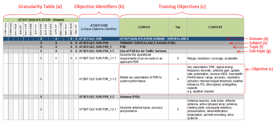 Figure 1: Structure of tables (a) Granularity table (Appendix 4a only) The granularity table indicates the stream(s) with which the objectives are associated. Where objectives are common to multiple streams, it is necessary to only include the objective once in the ATSEP training syllabus. (b) ATSEP unique objective identifier (UOID) This is a unique identifier for each objective. Where objectives are repeated across multiple streams, the UOID is linked to the parent domain. The structure of the UOID is the following: AREA.DOMAIN.SUBJECT\_topic#.subtopic#.objective# An example of a UOID decoding for ATSEP.QLF.SUR.PSR\_1.2.1: — ATSEP: fixed field that indicates the training area; — QLF.SUR.: phase of training (qualification) and domain (surveillance); — (Note: basic training uses only ‘BAS’ without a second field); — PSR: subject (primary surveillance radar); — \_1: topic number (PSR); — .2: subtopic number (antenna (PSR)); and — .1: objective number (1). (c) Training objectives Each training objective contains three mandatory elements: (1) Corpus A description of the required performance. It always contains an action verb at the beginning of the sentence to ensure that the outcome is observable. The action verb is always associated with a defined taxonomy. The tables at the end of this section list action verbs and their associated taxonomy levels. Those verbs and levels are used or may be used for training objectives. (2) Taxonomy Level A numerical representation of the classification of the action verb. (i) Level 1: basic knowledge of the subject. It is the ability to remember essential points, memorise data, and retrieve it. (ii) Level 2: the ability to understand and discuss the subject matter intelligently in order to describe and act on certain objects and events. (iii) Level 3: thorough knowledge of the subject and the ability to apply it with accuracy. The ability to make use of the repertoire of knowledge to develop plans and activate them. (iv) Level 4: the ability to establish a line of action within a unit of known applications by following the correct chronology and the adequate method to resolve a problem situation. This involves integrating known applications into a familiar situation. (v) Level 5: the ability to analyse new situations in order to elaborate and apply one or another relevant strategy to solve a complex problem. The defining feature is that the situation is qualitatively different to those previously met, requiring judgement and evaluation of options. The content illustrates and details performance. When the items are in a list, each of them is to be addressed as a minimum. ‘e.g.’ is used to indicate optional content. All content following ‘e.g.’ is provided to illustrate the type of content that could be used to meet the objective. When there is no mandatory content, the objective has to be performed according to the action verb. Where content refers to other documents (e.g. ICAO SARPs, EU regulations, etc.), users should take care to use the most recent version(s) of the referenced document(s) or its/their parts. (d) Domain The domain is indicated through white text on blue background. The following domains are defined: QLF.SHR SHARED (common part for all qualification domains); QLF.COM COMMUNICATION; QLF.NAV NAVIGATION; QLF.SUR SURVEILLANCE; QLF.DPR DATA PROCESSING; and QLF.SMC SYSTEM MONITORING AND CONTROL. In addition, basic training is also considered to be a domain in the tables: BAS BASIC. (e) Subject The subject is indicated through black text on dark grey background. A subject structures the domain into smaller elements. (f) Topic The topic is indicated through black text on mid grey background. A topic structures the subject into smaller elements. (g) Subtopic The subtopic is indicated through black text on light grey background. A subtopic structures the topic into smaller elements. (h) Action verbs The tables below list action verbs and their associated taxonomy levels that are used in training objectives. Definition of verbs — Level 1 <table border="1" cellpadding="0" cellspacing="0" width="605"><tr><td valign="top" width="102"><p><b>Verb</b></p></td><td valign="top" width="251"><p><b>Definition</b></p></td><td valign="top" width="251"><p><b>Example</b></p></td></tr><tr><td valign="top" width="102"><p><b>Define</b></p></td><td valign="top" width="251"><p>State what it is and what its limits are; state the definition.</p></td><td valign="top" width="251"><p>Define airborne safety nets.</p></td></tr><tr><td valign="top" width="102"><p><b>Draw</b></p></td><td valign="top" width="251"><p>Produce a picture, pattern, or diagram.</p></td><td valign="top" width="251"><p>Draw the MLAT system architecture.</p></td></tr><tr><td valign="top" width="102"><p><b>List</b></p></td><td valign="top" width="251"><p>Say one after the other.</p></td><td valign="top" width="251"><p>List the most common weather messages.</p></td></tr><tr><td valign="top" width="102"><p><b>Name</b></p></td><td valign="top" width="251"><p>Give the name of objects or procedures.</p></td><td valign="top" width="251"><p>Name a range of air-ground aviation-related network concepts.</p></td></tr><tr><td valign="top" width="102"><p><b>Recognise</b></p></td><td valign="top" width="251"><p>Know what it is, because you have seen it before.</p></td><td valign="top" width="251"><p>Recognise surveillance information on a display.</p></td></tr><tr><td valign="top" width="102"><p><b>State</b></p></td><td valign="top" width="251"><p>Say or write in a formal or definite way.</p></td><td valign="top" width="251"><p>State the function of a network management system.</p></td></tr></table> Definition of verbs — Level 2 <table border="1" cellpadding="0" cellspacing="0" width="605"><tr><td valign="top" width="103"><p><b>Verb</b></p></td><td valign="top" width="250"><p><b>Definition</b></p></td><td valign="top" width="252"><p><b>Example</b></p></td></tr><tr><td valign="top" width="103"><p><b>Characterise</b></p></td><td valign="top" width="250"><p>Describe the quality of features in something.</p></td><td valign="top" width="252"><p>Characterise navigation methods.</p></td></tr><tr><td valign="top" width="103"><p><b>Consider</b></p></td><td valign="top" width="250"><p>Think carefully about it.</p></td><td valign="top" width="252"><p>Consider the benefits of Critical Incident Stress Management (CISM).</p></td></tr><tr><td valign="top" width="103"><p><b>Demonstrate</b></p></td><td valign="top" width="250"><p>Describe and explain. Logically or mathematically, prove the truth of the statement.</p></td><td valign="top" width="252"><p>Demonstrate the use of middleware in an ATM environment.</p></td></tr><tr><td valign="top" width="103"><p><b>Describe</b></p></td><td valign="top" width="250"><p>Say what it is like or what happened.</p></td><td valign="top" width="252"><p>Describe the elements of Global Navigation Satellite System (GNSS) in Europe.</p></td></tr><tr><td valign="top" width="103"><p><b>Differentiate</b></p></td><td valign="top" width="250"><p>Show the difference between things.</p></td><td valign="top" width="252"><p>Differentiate conventional navigation from area navigation.</p></td></tr><tr><td valign="top" width="103"><p><b>Explain</b></p></td><td valign="top" width="250"><p>Give details about something or describe so that it can be understood.</p></td><td valign="top" width="252"><p>Explain the function of FDP.</p></td></tr><tr><td valign="top" width="103"><p><b>Take account of</b></p></td><td valign="top" width="250"><p>Take into consideration before deciding.</p></td><td valign="top" width="252"><p>Take account of hardware/software compatibility.</p></td></tr></table> Definition of verbs — Level 3 <table border="1" cellpadding="0" cellspacing="0" width="605"><thead><tr><td valign="top" width="103"><p><b>Verb</b></p></td><td valign="top" width="250"><p><b>Definition</b></p></td><td valign="top" width="252"><p><b>Example</b></p></td></tr></thead><tr><td valign="top" width="103"><p><b>Apply</b></p></td><td valign="top" width="250"><p>Use something in a situation or activity.</p></td><td valign="top" width="252"><p>Apply the principles of layers.</p></td></tr><tr><td valign="top" width="103"><p><b>Appreciate</b></p></td><td valign="top" width="250"><p>Understand a situation and know what is involved in a problem-solving situation, to state a plan without applying it.</p></td><td valign="top" width="252"><p>Appreciate how to troubleshoot a network.</p></td></tr><tr><td valign="top" width="103"><p><b>Calculate</b></p></td><td valign="top" width="250"><p>Discover from information you already have by arithmetic; to think about a possible cause of action in order to form an opinion or decide what to do.</p></td><td valign="top" width="252"><p>Calculate parameters of a line.</p></td></tr><tr><td valign="top" width="103"><p><b>Check</b></p></td><td valign="top" width="250"><p>Make sure the information is correct (satisfactory).</p></td><td valign="top" width="252"><p>Check the conformity of a system to ITU and national regulation.</p></td></tr><tr><td valign="top" width="103"><p><b>Decode</b></p></td><td valign="top" width="250"><p>Turn into ordinary writing, decipher.</p></td><td valign="top" width="252"><p>Decode a typical OLDI message.</p></td></tr><tr><td valign="top" width="103"><p><b>Estimate</b></p></td><td valign="top" width="250"><p>Form an approximate judgement of a number, form an opinion.</p></td><td valign="top" width="252"><p>Estimate the impact of security and integrity failure to the operational service.</p></td></tr><tr><td valign="top" width="103"><p><b>Identify</b></p></td><td valign="top" width="250"><p>Associate oneself inseparably with, establish the identity.</p></td><td valign="top" width="252"><p>Identify the major elements of the ADS-C system.</p></td></tr><tr><td valign="top" width="103"><p><b>Operate</b></p></td><td valign="top" width="250"><p>Conduct work on equipment.</p></td><td valign="top" width="252"><p>Operate measuring equipment.</p></td></tr><tr><td valign="top" width="103"><p><b>Perform</b></p></td><td valign="top" width="250"><p>Carry into effect, go through, execute.</p></td><td valign="top" width="252"><p>Perform measurements with generic radio test equipment.</p></td></tr><tr><td valign="top" width="103"><p><b>Use</b></p></td><td valign="top" width="250"><p>Employ for a purpose, handle as instrument, put into operation.</p></td><td valign="top" width="252"><p>Use appropriate vocabulary to communicate effectively on technical matters.</p></td></tr></table> Definition of verbs — Level 4 <table border="1" cellpadding="0" cellspacing="0" width="605"><tr><td valign="top" width="103"><p><b>Verb</b></p></td><td valign="top" width="250"><p><b>Definition</b></p></td><td valign="top" width="252"><p><b>Example</b></p></td></tr><tr><td valign="top" width="103"><p><b>Adjust</b></p></td><td valign="top" width="250"><p>Change to a new position, value or setting.</p></td><td valign="top" width="252"><p>Adjust a generic radio receiver.</p></td></tr><tr><td valign="top" width="103"><p><b>Analyse</b></p></td><td valign="top" width="250"><p>Examine minutely the constitution of. </p></td><td valign="top" width="252"><p>Analyse the block diagram of a generic radio receiver.</p></td></tr><tr><td valign="top" width="103"><p><b>Justify</b></p></td><td valign="top" width="250"><p>Show the rightness of a choice or of an option.</p></td><td valign="top" width="252"><p>Justify the occasions when it is necessary to downgrade an ILS facility performance category.</p></td></tr><tr><td valign="top" width="103"><p><b>Relate</b></p></td><td valign="top" width="250"><p>Establish link with.</p></td><td valign="top" width="252"><p>Relate VOR station design to operational requirement.</p></td></tr></table> Definition of verbs — Level 5 <table border="1" cellpadding="0" cellspacing="0" width="605"><tr><td valign="top" width="103"><p><b>Verb</b></p></td><td valign="top" width="250"><p><b>Definition</b></p></td><td valign="top" width="252"><p><b>Example</b></p></td></tr><tr><td valign="top" width="103"><p><b>Interpret</b></p></td><td valign="top" width="250"><p>Decide on the meaning or significance of something when there is a choice.</p></td><td valign="top" width="252"><p>Interpret ILS facility performance categories.</p></td></tr></table> (i) Acronyms The following abbreviations are used in the tables: <table border="1" cellpadding="0" cellspacing="0" width="604"><tr><td valign="top" width="110"><p><b>AAIM</b></p></td><td valign="top" width="495"><p>Aircraft Autonomous Integrity Monitoring</p></td></tr><tr><td valign="top" width="110"><p><b>ABAS</b></p></td><td valign="top" width="495"><p>Aircraft-Based Augmentation System</p></td></tr><tr><td valign="top" width="110"><p><b>ACARS</b></p></td><td valign="top" width="495"><p>Aircraft Communications Addressing and Reporting System</p></td></tr><tr><td valign="top" width="110"><p><b>ACAS</b></p></td><td valign="top" width="495"><p>Airborne Collision Avoidance System</p></td></tr><tr><td valign="top" width="110"><p><b>ACC</b></p></td><td valign="top" width="495"><p>Area Control Centre</p></td></tr><tr><td valign="top" width="110"><p><b>A/D</b></p></td><td valign="top" width="495"><p>Analogue/Digital</p></td></tr><tr><td valign="top" width="110"><p><b>ADEX-P</b></p></td><td valign="top" width="495"><p>ATS Data Exchange Presentation</p></td></tr><tr><td valign="top" width="110"><p><b>ADS</b></p></td><td valign="top" width="495"><p>Automatic Dependent Surveillance</p></td></tr><tr><td valign="top" width="110"><p><b>ADS B</b></p></td><td valign="top" width="495"><p>ADS — Broadcast</p></td></tr><tr><td valign="top" width="110"><p><b>ADS C</b></p></td><td valign="top" width="495"><p>ADS — Contract</p></td></tr><tr><td valign="top" width="110"><p><b>ADF</b></p></td><td valign="top" width="495"><p>Automatic Direction Finder</p></td></tr><tr><td valign="top" width="110"><p><b>AFDX</b></p></td><td valign="top" width="495"><p>Avionics Full-duplex Ethernet Switch</p></td></tr><tr><td valign="top" width="110"><p><b>AFTN</b></p></td><td valign="top" width="495"><p>Aeronautical Fixed Telecommunications Network</p></td></tr><tr><td valign="top" width="110"><p><b>AGC</b></p></td><td valign="top" width="495"><p>Automatic Gain Control</p></td></tr><tr><td valign="top" width="110"><p><b>AIC</b></p></td><td valign="top" width="495"><p>Aeronautical Information Circular</p></td></tr><tr><td valign="top" width="110"><p><b>AIDC</b></p></td><td valign="top" width="495"><p>ATS Interfacility Data Communications</p></td></tr><tr><td valign="top" width="110"><p><b>AIP</b></p></td><td valign="top" width="495"><p>Aeronautical Information Publication</p></td></tr><tr><td valign="top" width="110"><p><b>AIRAC</b></p></td><td valign="top" width="495"><p>Aeronautical Information Regulation and Control</p></td></tr><tr><td valign="top" width="110"><p><b>AIS</b></p></td><td valign="top" width="495"><p>Aeronautical Information Services</p></td></tr><tr><td valign="top" width="110"><p><b>ALARP</b></p></td><td valign="top" width="495"><p>As Low As Reasonably Practicable</p></td></tr><tr><td valign="top" width="110"><p><b>AMAN</b></p></td><td valign="top" width="495"><p>Arrival Manager</p></td></tr><tr><td valign="top" width="110"><p><b>AMHS</b></p></td><td valign="top" width="495"><p>Aeronautical Message Handling System</p></td></tr><tr><td valign="top" width="110"><p><b>AMSS</b></p></td><td valign="top" width="495"><p>Automatic Message Switching System</p></td></tr><tr><td valign="top" width="110"><p><b>ANS</b></p></td><td valign="top" width="495"><p>Air Navigation Services</p></td></tr><tr><td valign="top" width="110"><p><b>ANSP</b></p></td><td valign="top" width="495"><p>ANS Provider</p></td></tr><tr><td valign="top" width="110"><p><b>APV</b></p></td><td valign="top" width="495"><p>Approach Procedure with Vertical guidance</p></td></tr><tr><td valign="top" width="110"><p><b>APW</b></p></td><td valign="top" width="495"><p>Area Proximity Warning</p></td></tr><tr><td valign="top" width="110"><p><b>ARINC</b></p></td><td valign="top" width="495"><p>Aeronautical Radio Incorporated</p></td></tr><tr><td valign="top" width="110"><p><b>ARTAS</b></p></td><td valign="top" width="495"><p>ATC Radar Tracker and Server</p></td></tr><tr><td valign="top" width="110"><p><b>ASAS</b></p></td><td valign="top" width="495"><p>Airborne Separation Assistance/Assurance System</p></td></tr><tr><td valign="top" width="110"><p><b>ASM</b></p></td><td valign="top" width="495"><p>Airspace Management</p></td></tr><tr><td valign="top" width="110"><p><b>ASMGCS</b></p></td><td valign="top" width="495"><p>Advanced SMGCS</p></td></tr><tr><td valign="top" width="110"><p><b>ASTERIX</b></p></td><td valign="top" width="495"><p>All-purpose Structured EUROCONTROL Radar Information Exchange</p></td></tr><tr><td valign="top" width="110"><p><b>ATC</b></p></td><td valign="top" width="495"><p>Air Traffic Control</p></td></tr><tr><td valign="top" width="110"><p><b>ATFCM</b></p></td><td valign="top" width="495"><p>Air Traffic Flow and Capacity Management</p></td></tr><tr><td valign="top" width="110"><p><b>ATIS</b></p></td><td valign="top" width="495"><p>Automatic Terminal Information Service</p></td></tr><tr><td valign="top" width="110"><p><b>ATM</b></p></td><td valign="top" width="495"><p>Air Traffic Management</p></td></tr><tr><td valign="top" width="110"><p><b>ATN</b></p></td><td valign="top" width="495"><p>Aeronautical Telecommunication Network</p></td></tr><tr><td valign="top" width="110"><p><b>ATS</b></p></td><td valign="top" width="495"><p>Air Traffic Services</p></td></tr><tr><td valign="top" width="110"><p><b>ATSEP</b></p></td><td valign="top" width="495"><p>Air Traffic Safety Electronics Personnel</p></td></tr><tr><td valign="top" width="110"><p><b>AUGUR</b></p></td><td valign="top" width="495"><p>EUROCONTROL RAIM Prediction Tool</p></td></tr><tr><td valign="top" width="110"><p><b>BATAP</b></p></td><td valign="top" width="495"><p>‘Type-B’ Application-to-Application Protocol</p></td></tr><tr><td valign="top" width="110"><p><b>BDS</b></p></td><td valign="top" width="495"><p>Binary Data Store</p></td></tr><tr><td valign="top" width="110"><p><b>BER</b></p></td><td valign="top" width="495"><p>Bit Error Rate</p></td></tr><tr><td valign="top" width="110"><p><b>BITE</b></p></td><td valign="top" width="495"><p>Built-In Test Equipment</p></td></tr><tr><td valign="top" width="110"><p><b>B-RNAV</b></p></td><td valign="top" width="495"><p>Basic-RNAV</p></td></tr><tr><td valign="top" width="110"><p><b>CAA</b></p></td><td valign="top" width="495"><p>Civil Aviation Authority</p></td></tr><tr><td valign="top" width="110"><p><b>CB</b></p></td><td valign="top" width="495"><p>Cumulonimbus</p></td></tr><tr><td valign="top" width="110"><p><b>CBT</b></p></td><td valign="top" width="495"><p>Computer-Based Training</p></td></tr><tr><td valign="top" width="110"><p><b>CDM</b></p></td><td valign="top" width="495"><p>Collaborative Decision-Making</p></td></tr><tr><td valign="top" width="110"><p><b>CDTI</b></p></td><td valign="top" width="495"><p>Cockpit Display of Traffic Information</p></td></tr><tr><td valign="top" width="110"><p><b>CFMU</b></p></td><td valign="top" width="495"><p>Central Flow Management Unit</p></td></tr><tr><td valign="top" width="110"><p><b>CIDIN</b></p></td><td valign="top" width="495"><p>Common ICAO Data Interchange Network</p></td></tr><tr><td valign="top" width="110"><p><b>CISM</b></p></td><td valign="top" width="495"><p>Critical Incident Stress Management</p></td></tr><tr><td valign="top" width="110"><p><b>CIV</b></p></td><td valign="top" width="495"><p>Civil</p></td></tr><tr><td valign="top" width="110"><p><b>CLAM</b></p></td><td valign="top" width="495"><p>Cleared flight Level Adherence Monitoring</p></td></tr><tr><td valign="top" width="110"><p><b>CLIMAX</b></p></td><td valign="top" width="495"><p>Multi-station carrier offset mode, with voting override</p></td></tr><tr><td valign="top" width="110"><p><b>CMS</b></p></td><td valign="top" width="495"><p>Control and Monitoring System</p></td></tr><tr><td valign="top" width="110"><p><b>CNS/ATM</b></p></td><td valign="top" width="495"><p>Communication Navigation and Surveillance/Air Traffic Management</p></td></tr><tr><td valign="top" width="110"><p><b>CORA</b></p></td><td valign="top" width="495"><p>Conflict Resolution Advisory</p></td></tr><tr><td valign="top" width="110"><p><b>CORBA</b></p></td><td valign="top" width="495"><p>Common Object Request Broker Architecture</p></td></tr><tr><td valign="top" width="110"><p><b>COTS</b></p></td><td valign="top" width="495"><p>Commercial off-the-Shelf</p></td></tr><tr><td valign="top" width="110"><p><b>CPDLC</b></p></td><td valign="top" width="495"><p>Controller-Pilot Data Link Communications</p></td></tr><tr><td valign="top" width="110"><p><b>CRT</b></p></td><td valign="top" width="495"><p>Cathode Ray Tube</p></td></tr><tr><td valign="top" width="110"><p><b>CSU</b></p></td><td valign="top" width="495"><p>Control Sector Unit</p></td></tr><tr><td valign="top" width="110"><p><b>CTR</b></p></td><td valign="top" width="495"><p>Control Zone</p></td></tr><tr><td valign="top" width="110"><p><b>CVOR</b></p></td><td valign="top" width="495"><p>Conventional VOR</p></td></tr><tr><td valign="top" width="110"><p><b>CWP</b></p></td><td valign="top" width="495"><p>Controller Work Position</p></td></tr><tr><td valign="top" width="110"><p><b>DCL</b></p></td><td valign="top" width="495"><p>Departure Clearance</p></td></tr><tr><td valign="top" width="110"><p><b>DDF</b></p></td><td valign="top" width="495"><p>Doppler DF</p></td></tr><tr><td valign="top" width="110"><p><b>DDM</b></p></td><td valign="top" width="495"><p>Difference of Depth of Modulation</p></td></tr><tr><td valign="top" width="110"><p><b>DF</b></p></td><td valign="top" width="495"><p>Direction Finding</p></td></tr><tr><td valign="top" width="110"><p><b>DLIC</b></p></td><td valign="top" width="495"><p>Data Link Initiation Capability</p></td></tr><tr><td valign="top" width="110"><p><b>DMAN</b></p></td><td valign="top" width="495"><p>Departure Manager</p></td></tr><tr><td valign="top" width="110"><p><b>DME</b></p></td><td valign="top" width="495"><p>Distance Measuring Equipment</p></td></tr><tr><td valign="top" width="110"><p><b>DPSK</b></p></td><td valign="top" width="495"><p>Differential Phase Shift Keying</p></td></tr><tr><td valign="top" width="110"><p><b>DTMF</b></p></td><td valign="top" width="495"><p>Dual Tone Modulation-Frequency</p></td></tr><tr><td valign="top" width="110"><p><b>DVOR</b></p></td><td valign="top" width="495"><p>Doppler VOR</p></td></tr><tr><td valign="top" width="110"><p><b>EAD</b></p></td><td valign="top" width="495"><p>European Aeronautical Database</p></td></tr><tr><td valign="top" width="110"><p><b>EAN</b></p></td><td valign="top" width="495"><p>European ANSP Network</p></td></tr><tr><td valign="top" width="110"><p><b>EASA</b></p></td><td valign="top" width="495"><p>European Aviation Safety Agency</p></td></tr><tr><td valign="top" width="110"><p><b>ECAC</b></p></td><td valign="top" width="495"><p>European Civil Aviation Conference</p></td></tr><tr><td valign="top" width="110"><p><b>EFQM</b></p></td><td valign="top" width="495"><p>European Foundation for Quality Management</p></td></tr><tr><td valign="top" width="110"><p><b>EGNOS</b></p></td><td valign="top" width="495"><p>European Geostationary Navigation Overlay Service</p></td></tr><tr><td valign="top" width="110"><p><b>EGPWS</b></p></td><td valign="top" width="495"><p>Enhanced Ground Proximity Warning System</p></td></tr><tr><td valign="top" width="110"><p><b>EHS</b></p></td><td valign="top" width="495"><p>Enhanced Mode S</p></td></tr><tr><td valign="top" width="110"><p><b>EHT</b></p></td><td valign="top" width="495"><p>Extremely High Tension</p></td></tr><tr><td valign="top" width="110"><p><b>EJB</b></p></td><td valign="top" width="495"><p>Enterprise Java Bean</p></td></tr><tr><td valign="top" width="110"><p><b>ELS</b></p></td><td valign="top" width="495"><p>Elementary Mode S</p></td></tr><tr><td valign="top" width="110"><p><b>EMC</b></p></td><td valign="top" width="495"><p>Electromagnetic Compatibility</p></td></tr><tr><td valign="top" width="110"><p><b>EMI</b></p></td><td valign="top" width="495"><p>Electromagnetic Interference</p></td></tr><tr><td valign="top" width="110"><p><b>ETFMS</b></p></td><td valign="top" width="495"><p>Enhanced Tactical FMS</p></td></tr><tr><td valign="top" width="110"><p><b>EU</b></p></td><td valign="top" width="495"><p>European Union</p></td></tr><tr><td valign="top" width="110"><p><b>EUROCAE</b></p></td><td valign="top" width="495"><p>European Civil Aviation Electronics</p></td></tr><tr><td valign="top" width="110"><p><b>EUROCONTROL</b></p></td><td valign="top" width="495"><p>European Organisation for the Safety of Air Navigation</p></td></tr><tr><td valign="top" width="110"><p><b>FAA</b></p></td><td valign="top" width="495"><p>Federal Aviation Administration (US)</p></td></tr><tr><td valign="top" width="110"><p><b>FANS</b></p></td><td valign="top" width="495"><p>Future Air Navigation Systems</p></td></tr><tr><td valign="top" width="110"><p><b>FDP</b></p></td><td valign="top" width="495"><p>Flight Data Processing</p></td></tr><tr><td valign="top" width="110"><p><b>FDPS</b></p></td><td valign="top" width="495"><p>FDP System</p></td></tr><tr><td valign="top" width="110"><p><b>FFM</b></p></td><td valign="top" width="495"><p>Far Field Monitor</p></td></tr><tr><td valign="top" width="110"><p><b>FHA</b></p></td><td valign="top" width="495"><p>Functional Hazard Assessment</p></td></tr><tr><td valign="top" width="110"><p><b>FIR</b></p></td><td valign="top" width="495"><p>Flight Information Region</p></td></tr><tr><td valign="top" width="110"><p><b>FMS</b></p></td><td valign="top" width="495"><p>Flight Management System</p></td></tr><tr><td valign="top" width="110"><p><b>FMTP</b></p></td><td valign="top" width="495"><p>Flight Plan Messaging Transport Protocol</p></td></tr><tr><td valign="top" width="110"><p><b>FoM</b></p></td><td valign="top" width="495"><p>Figures of Merit</p></td></tr><tr><td valign="top" width="110"><p><b>FPL</b></p></td><td valign="top" width="495"><p>(Filed) Flight Plan</p></td></tr><tr><td valign="top" width="110"><p><b>FRUIT</b></p></td><td valign="top" width="495"><p>False Reply Unsynchronised in Time</p></td></tr><tr><td valign="top" width="110"><p><b>FUA</b></p></td><td valign="top" width="495"><p>Flexible Use of Airspace</p></td></tr><tr><td valign="top" width="110"><p><b>GALILEO</b></p></td><td valign="top" width="495"><p>Satellite radio navigation system</p></td></tr><tr><td valign="top" width="110"><p><b>GBAS</b></p></td><td valign="top" width="495"><p>Ground-Based Augmentation System</p></td></tr><tr><td valign="top" width="110"><p><b>GLONASS</b></p></td><td valign="top" width="495"><p>GLObal’naya NAvigatsionnaya Sputnikovaya Sistema (Global Navigation Satellite System)</p></td></tr><tr><td valign="top" width="110"><p><b>GNSS</b></p></td><td valign="top" width="495"><p>Global Navigation Satellite System</p></td></tr><tr><td valign="top" width="110"><p><b>GP</b></p></td><td valign="top" width="495"><p>Glide Path</p></td></tr><tr><td valign="top" width="110"><p><b>GPS</b></p></td><td valign="top" width="495"><p>Global Positioning System</p></td></tr><tr><td valign="top" width="110"><p><b>GRAS</b></p></td><td valign="top" width="495"><p>Ground-based Regional Augmentation System</p></td></tr><tr><td valign="top" width="110"><p><b>GSA</b></p></td><td valign="top" width="495"><p>GNSS Supervisory Authority</p></td></tr><tr><td valign="top" width="110"><p><b>GTC</b></p></td><td valign="top" width="495"><p>Gain/Time Control</p></td></tr><tr><td valign="top" width="110"><p><b>HF</b></p></td><td valign="top" width="495"><p>High Frequency</p></td></tr><tr><td valign="top" width="110"><p><b>HFDL</b></p></td><td valign="top" width="495"><p>High Frequency Data Link</p></td></tr><tr><td valign="top" width="110"><p><b>HMI</b></p></td><td valign="top" width="495"><p>Human-Machine Interface</p></td></tr><tr><td valign="top" width="110"><p><b>HPA</b></p></td><td valign="top" width="495"><p>High Power Amplifier</p></td></tr><tr><td valign="top" width="110"><p><b>HSI</b></p></td><td valign="top" width="495"><p>Horizontal Situation Indication</p></td></tr><tr><td valign="top" width="110"><p><b>HV</b></p></td><td valign="top" width="495"><p>High Voltage</p></td></tr><tr><td valign="top" width="110"><p><b>HW</b></p></td><td valign="top" width="495"><p>Hardware</p></td></tr><tr><td valign="top" width="110"><p><b>Hz</b></p></td><td valign="top" width="495"><p>Hertz</p></td></tr><tr><td valign="top" width="110"><p><b>ICAO</b></p></td><td valign="top" width="495"><p>International Civil Aviation Organization</p></td></tr><tr><td valign="top" width="110"><p><b>IDF</b></p></td><td valign="top" width="495"><p>Interferometric DF</p></td></tr><tr><td valign="top" width="110"><p><b>IF</b></p></td><td valign="top" width="495"><p>Intermediate Frequency</p></td></tr><tr><td valign="top" width="110"><p><b>IFF</b></p></td><td valign="top" width="495"><p>Identification Friend/Foe</p></td></tr><tr><td valign="top" width="110"><p><b>IFPS</b></p></td><td valign="top" width="495"><p>(Integrated) Initial Flight Plan Processing System</p></td></tr><tr><td valign="top" width="110"><p><b>ILS</b></p></td><td valign="top" width="495"><p>Instrument Landing System</p></td></tr><tr><td valign="top" width="110"><p><b>INS</b></p></td><td valign="top" width="495"><p>Inertial Navigation System</p></td></tr><tr><td valign="top" width="110"><p><b>I/O</b></p></td><td valign="top" width="495"><p>Input/Output</p></td></tr><tr><td valign="top" width="110"><p><b>IP</b></p></td><td valign="top" width="495"><p>Internet Protocol</p></td></tr><tr><td valign="top" width="110"><p><b>IRS</b></p></td><td valign="top" width="495"><p>Inertial Reference System</p></td></tr><tr><td valign="top" width="110"><p><b>IRVR</b></p></td><td valign="top" width="495"><p>Instrument Runway Visual Range</p></td></tr><tr><td valign="top" width="110"><p><b>I/Q</b></p></td><td valign="top" width="495"><p>In phase and Quadrature</p></td></tr><tr><td valign="top" width="110"><p><b>ISDN</b></p></td><td valign="top" width="495"><p>Integrated Services Digital Network</p></td></tr><tr><td valign="top" width="110"><p><b>ISLS</b></p></td><td valign="top" width="495"><p>Interrogator Side Lobe Suppression</p></td></tr><tr><td valign="top" width="110"><p><b>IISLS</b></p></td><td valign="top" width="495"><p>Improved Interrogator Side Lobe Suppression</p></td></tr><tr><td valign="top" width="110"><p><b>iTEC</b></p></td><td valign="top" width="495"><p>Interoperability Through European Collaboration</p></td></tr><tr><td valign="top" width="110"><p><b>ITU</b></p></td><td valign="top" width="495"><p>International Telecommunication Union</p></td></tr><tr><td valign="top" width="110"><p><b>ISO</b></p></td><td valign="top" width="495"><p>International Standards Organisation</p></td></tr><tr><td valign="top" width="110"><p><b>LAM</b></p></td><td valign="top" width="495"><p>Local Area Multilateration</p></td></tr><tr><td valign="top" width="110"><p><b>LAN</b></p></td><td valign="top" width="495"><p>Local Area Network</p></td></tr><tr><td valign="top" width="110"><p><b>LAPB</b></p></td><td valign="top" width="495"><p>Link Access Protocol, Balanced</p></td></tr><tr><td valign="top" width="110"><p><b>LCD</b></p></td><td valign="top" width="495"><p>Liquid-Crystal Display</p></td></tr><tr><td valign="top" width="110"><p><b>LLZ</b></p></td><td valign="top" width="495"><p>Localiser</p></td></tr><tr><td valign="top" width="110"><p><b>LNA</b></p></td><td valign="top" width="495"><p>Low Noise Amplifier</p></td></tr><tr><td valign="top" width="110"><p><b>LVP</b></p></td><td valign="top" width="495"><p>Low Visibility Procedures</p></td></tr><tr><td valign="top" width="110"><p><b>MDS</b></p></td><td valign="top" width="495"><p>Minimum Detectable Signal</p></td></tr><tr><td valign="top" width="110"><p><b>MET </b></p></td><td valign="top" width="495"><p>Meteorology</p></td></tr><tr><td valign="top" width="110"><p><b>METAR</b></p></td><td valign="top" width="495"><p>Meteorological Actual Report</p></td></tr><tr><td valign="top" width="110"><p><b>MFC</b></p></td><td valign="top" width="495"><p>Multi-Frequency Coding</p></td></tr><tr><td valign="top" width="110"><p><b>MHz</b></p></td><td valign="top" width="495"><p>Megahertz</p></td></tr><tr><td valign="top" width="110"><p><b>MIL</b></p></td><td valign="top" width="495"><p>Military</p></td></tr><tr><td valign="top" width="110"><p><b>MLAT</b></p></td><td valign="top" width="495"><p>Multilateration</p></td></tr><tr><td valign="top" width="110"><p><b>MLS</b></p></td><td valign="top" width="495"><p>Microwave Landing System</p></td></tr><tr><td valign="top" width="110"><p><b>MOTNE</b></p></td><td valign="top" width="495"><p>Meteorological Operational Telecommunications Network Europe</p></td></tr><tr><td valign="top" width="110"><p><b>MRP</b></p></td><td valign="top" width="495"><p>Multi-radar Processing</p></td></tr><tr><td valign="top" width="110"><p><b>MRT</b></p></td><td valign="top" width="495"><p>Multi-radar Tracker</p></td></tr><tr><td valign="top" width="110"><p><b>MSAW</b></p></td><td valign="top" width="495"><p>Minimum Safe Altitude Warning</p></td></tr><tr><td valign="top" width="110"><p><b>MSSR</b></p></td><td valign="top" width="495"><p>Mono-pulse SSR</p></td></tr><tr><td valign="top" width="110"><p><b>MTBF</b></p></td><td valign="top" width="495"><p>Mean Time Between Failure</p></td></tr><tr><td valign="top" width="110"><p><b>MTCD</b></p></td><td valign="top" width="495"><p>Medium-Term Conflict Detection</p></td></tr><tr><td valign="top" width="110"><p><b>MTD</b></p></td><td valign="top" width="495"><p>Moving Target Detection</p></td></tr><tr><td valign="top" width="110"><p><b>NAVAID</b></p></td><td valign="top" width="495"><p>Navigation(al) Aid</p></td></tr><tr><td valign="top" width="110"><p><b>ND</b></p></td><td valign="top" width="495"><p>Navigation Display</p></td></tr><tr><td valign="top" width="110"><p><b>NEAN</b></p></td><td valign="top" width="495"><p>North European ADS-B Network</p></td></tr><tr><td valign="top" width="110"><p><b>NDB</b></p></td><td valign="top" width="495"><p>Non-Directional Beacon</p></td></tr><tr><td valign="top" width="110"><p><b>NOP</b></p></td><td valign="top" width="495"><p>Network Operations Plan</p></td></tr><tr><td valign="top" width="110"><p><b>NOTAM</b></p></td><td valign="top" width="495"><p>Notice to Airmen</p></td></tr><tr><td valign="top" width="110"><p><b>NPA</b></p></td><td valign="top" width="495"><p>Non-Precision Approach</p></td></tr><tr><td valign="top" width="110"><p><b>NRA</b></p></td><td valign="top" width="495"><p>Non-Radar Area</p></td></tr><tr><td valign="top" width="110"><p><b>NSA</b></p></td><td valign="top" width="495"><p>National Supervisory Authority</p></td></tr><tr><td valign="top" width="110"><p><b>OJTI</b></p></td><td valign="top" width="495"><p>On-The-Job Training Instructor</p></td></tr><tr><td valign="top" width="110"><p><b>OLDI</b></p></td><td valign="top" width="495"><p>On-Line Data Interchange</p></td></tr><tr><td valign="top" width="110"><p><b>OS</b></p></td><td valign="top" width="495"><p>Operating System</p></td></tr><tr><td valign="top" width="110"><p><b>OSI</b></p></td><td valign="top" width="495"><p>Open System Interconnection</p></td></tr><tr><td valign="top" width="110"><p><b>OST</b></p></td><td valign="top" width="495"><p>On-site Training</p></td></tr><tr><td valign="top" width="110"><p><b>OTM</b></p></td><td valign="top" width="495"><p>Object Transaction Monitor</p></td></tr><tr><td valign="top" width="110"><p><b>PA</b></p></td><td valign="top" width="495"><p>Precision Approach</p></td></tr><tr><td valign="top" width="110"><p><b>PABX</b></p></td><td valign="top" width="495"><p>Private Automatic Branch Exchange</p></td></tr><tr><td valign="top" width="110"><p><b>PBN</b></p></td><td valign="top" width="495"><p>Performance-Based Navigation</p></td></tr><tr><td valign="top" width="110"><p><b>PCM</b></p></td><td valign="top" width="495"><p>Pulse Code Modulation</p></td></tr><tr><td valign="top" width="110"><p><b>PD</b></p></td><td valign="top" width="495"><p>Probability of Detection</p></td></tr><tr><td valign="top" width="110"><p><b>PENS</b></p></td><td valign="top" width="495"><p>Pan-European Fixed Network Services</p></td></tr><tr><td valign="top" width="110"><p><b>PFD</b></p></td><td valign="top" width="495"><p>Primary Flight Display</p></td></tr><tr><td valign="top" width="110"><p><b>PPI</b></p></td><td valign="top" width="495"><p>Plan Position Indicator</p></td></tr><tr><td valign="top" width="110"><p><b>PRF</b></p></td><td valign="top" width="495"><p>Pulse Repetition Frequency</p></td></tr><tr><td valign="top" width="110"><p><b>P-RNAV</b></p></td><td valign="top" width="495"><p>Precision RNAV</p></td></tr><tr><td valign="top" width="110"><p><b>PSD</b></p></td><td valign="top" width="495"><p>Phase Sensitive Detector</p></td></tr><tr><td valign="top" width="110"><p><b>PSSA</b></p></td><td valign="top" width="495"><p>Preliminary System Safety Assessment</p></td></tr><tr><td valign="top" width="110"><p><b>PSR</b></p></td><td valign="top" width="495"><p>Primary Surveillance Radar</p></td></tr><tr><td valign="top" width="110"><p><b>QoS</b></p></td><td valign="top" width="495"><p>Quality of Service</p></td></tr><tr><td valign="top" width="110"><p><b>QNH</b></p></td><td valign="top" width="495"><p>Q-code for atmospheric pressure at sea level</p></td></tr><tr><td valign="top" width="110"><p><b>Qsig</b></p></td><td valign="top" width="495"><p>Quality of signal</p></td></tr><tr><td valign="top" width="110"><p><b>RAIM</b></p></td><td valign="top" width="495"><p>Receiver Autonomous Integrity Monitoring</p></td></tr><tr><td valign="top" width="110"><p><b>RAPNET</b></p></td><td valign="top" width="495"><p>(European) Regional Aeronautical Packet switched Network (CBN + DAKOS)</p></td></tr><tr><td valign="top" width="110"><p><b>RAPS</b></p></td><td valign="top" width="495"><p>Recording, Analysis, Playback and Simulation system for radar data (COMSOFT)</p></td></tr><tr><td valign="top" width="110"><p><b>RDP</b></p></td><td valign="top" width="495"><p>Radar Data Processing</p></td></tr><tr><td valign="top" width="110"><p><b>RCA</b></p></td><td valign="top" width="495"><p>Remote Client Application</p></td></tr><tr><td valign="top" width="110"><p><b>RF</b></p></td><td valign="top" width="495"><p>Radio Frequency</p></td></tr><tr><td valign="top" width="110"><p><b>RMI</b></p></td><td valign="top" width="495"><p>Relative Magnetic Indicator</p></td></tr><tr><td valign="top" width="110"><p><b>RNAV</b></p></td><td valign="top" width="495"><p>Area Navigation</p></td></tr><tr><td valign="top" width="110"><p><b>RNP</b></p></td><td valign="top" width="495"><p>Required Navigation Performance</p></td></tr><tr><td valign="top" width="110"><p><b>RPL</b></p></td><td valign="top" width="495"><p>Repetitive Flight Plan</p></td></tr><tr><td valign="top" width="110"><p><b>RSLS</b></p></td><td valign="top" width="495"><p>Receiver Sidelobe Suppression</p></td></tr><tr><td valign="top" width="110"><p><b>R/T</b></p></td><td valign="top" width="495"><p>Radiotelephony</p></td></tr><tr><td valign="top" width="110"><p><b>RTCA</b></p></td><td valign="top" width="495"><p>Radio Technical Commission for Aeronautics</p></td></tr><tr><td valign="top" width="110"><p><b>RUP</b></p></td><td valign="top" width="495"><p>Rational Unified Process</p></td></tr><tr><td valign="top" width="110"><p><b>RVR</b></p></td><td valign="top" width="495"><p>Runway Visual Range</p></td></tr><tr><td valign="top" width="110"><p><b>RX</b></p></td><td valign="top" width="495"><p>Receiver</p></td></tr><tr><td valign="top" width="110"><p><b>SAR</b></p></td><td valign="top" width="495"><p>Specific Energy Absorption Rate</p></td></tr><tr><td valign="top" width="110"><p><b>SARPS</b></p></td><td valign="top" width="495"><p>Standards And Recommended Practices</p></td></tr><tr><td valign="top" width="110"><p><b>SASS</b></p></td><td valign="top" width="495"><p>Surveillance Analysis Support System</p></td></tr><tr><td valign="top" width="110"><p><b>SASS-C</b></p></td><td valign="top" width="495"><p>SASS-Centre</p></td></tr><tr><td valign="top" width="110"><p><b>SASS-S</b></p></td><td valign="top" width="495"><p>SASS-Sensor</p></td></tr><tr><td valign="top" width="110"><p><b>SATCOM</b></p></td><td valign="top" width="495"><p>Satellite Communications</p></td></tr><tr><td valign="top" width="110"><p><b>SBAS</b></p></td><td valign="top" width="495"><p>Satellite-Based Augmentation System</p></td></tr><tr><td valign="top" width="110"><p><b>SCAS</b></p></td><td valign="top" width="495"><p>Surveillance Coverage Analysis Suite</p></td></tr><tr><td valign="top" width="110"><p><b>SCAT-1</b></p></td><td valign="top" width="495"><p>Special Category 1</p></td></tr><tr><td valign="top" width="110"><p><b>SDM</b></p></td><td valign="top" width="495"><p>Sum of Depth of Modulation</p></td></tr><tr><td valign="top" width="110"><p><b>SDP</b></p></td><td valign="top" width="495"><p>Surveillance Data Processing</p></td></tr><tr><td valign="top" width="110"><p><b>S/E</b></p></td><td valign="top" width="495"><p>System/Equipment</p></td></tr><tr><td valign="top" width="110"><p><b>SELCAL</b></p></td><td valign="top" width="495"><p>Selective Calling</p></td></tr><tr><td valign="top" width="110"><p><b>SESAR</b></p></td><td valign="top" width="495"><p>Single European Sky AM Research</p></td></tr><tr><td valign="top" width="110"><p><b>SID</b></p></td><td valign="top" width="495"><p>Standard Instrument Departure</p></td></tr><tr><td valign="top" width="110"><p><b>SITA</b></p></td><td valign="top" width="495"><p>Société Internationale de Télécommunications Aéronautiques (France)</p></td></tr><tr><td valign="top" width="110"><p><b>SMC</b></p></td><td valign="top" width="495"><p>System Monitoring and Control</p></td></tr><tr><td valign="top" width="110"><p><b>SMR</b></p></td><td valign="top" width="495"><p>Surface Movement Radar</p></td></tr><tr><td valign="top" width="110"><p><b>SMS</b></p></td><td valign="top" width="495"><p>Safety Management System</p></td></tr><tr><td valign="top" width="110"><p><b>S/N</b></p></td><td valign="top" width="495"><p>Signal/Noise</p></td></tr><tr><td valign="top" width="110"><p><b>SNOWTAM</b></p></td><td valign="top" width="495"><p>NOTAM on Snow conditions</p></td></tr><tr><td valign="top" width="110"><p><b>SNMP</b></p></td><td valign="top" width="495"><p>Simple Network Management Protocol</p></td></tr><tr><td valign="top" width="110"><p><b>SPI</b></p></td><td valign="top" width="495"><p>Special Pulse Identification or Special Position Identification Pulse (SSR)</p></td></tr><tr><td valign="top" width="110"><p><b>SRC</b></p></td><td valign="top" width="495"><p>Safety Regulation Commission (EUROCONTROL)</p></td></tr><tr><td valign="top" width="110"><p><b>SSA</b></p></td><td valign="top" width="495"><p>System Safety Assessment</p></td></tr><tr><td valign="top" width="110"><p><b>SSR</b></p></td><td valign="top" width="495"><p>Secondary Surveillance Radar</p></td></tr><tr><td valign="top" width="110"><p><b>STC</b></p></td><td valign="top" width="495"><p>Sensitivity Time Control</p></td></tr><tr><td valign="top" width="110"><p><b>STCA</b></p></td><td valign="top" width="495"><p>Short-Term Conflict Alert</p></td></tr><tr><td valign="top" width="110"><p><b>SV</b></p></td><td valign="top" width="495"><p>Supervisor</p></td></tr><tr><td valign="top" width="110"><p><b>SW</b></p></td><td valign="top" width="495"><p>Software</p></td></tr><tr><td valign="top" width="110"><p><b>SWALs</b></p></td><td valign="top" width="495"><p>Software Assurance Levels</p></td></tr><tr><td valign="top" width="110"><p></p></td><td valign="top" width="495"></td></tr><tr><td valign="top" width="110"><p><b>SWIM</b></p></td><td valign="top" width="495"><p>System Wide Information Management</p></td></tr><tr><td valign="top" width="110"><p><b>SWR</b></p></td><td valign="top" width="495"><p>Standing Wave Ratio</p></td></tr><tr><td valign="top" width="110"><p><b>TACAN</b></p></td><td valign="top" width="495"><p>UHF Tactical Air Navigation aid</p></td></tr><tr><td valign="top" width="110"><p><b>TAF</b></p></td><td valign="top" width="495"><p>Terminal Area Forecast</p></td></tr><tr><td valign="top" width="110"><p><b>TCAS</b></p></td><td valign="top" width="495"><p>Transponder Collision Avoidance System</p></td></tr><tr><td valign="top" width="110"><p><b>TCP</b></p></td><td valign="top" width="495"><p>Transmission Control Protocol</p></td></tr><tr><td valign="top" width="110"><p><b>TDOA</b></p></td><td valign="top" width="495"><p>Time Difference on Arrival</p></td></tr><tr><td valign="top" width="110"><p><b>TFT</b></p></td><td valign="top" width="495"><p>Thin Film Transistor</p></td></tr><tr><td valign="top" width="110"><p><b>TIS</b></p></td><td valign="top" width="495"><p>Traffic Information Service</p></td></tr><tr><td valign="top" width="110"><p><b>TMA</b></p></td><td valign="top" width="495"><p>Terminal Area</p></td></tr><tr><td valign="top" width="110"><p><b>TRM</b></p></td><td valign="top" width="495"><p>Team Resource Management</p></td></tr><tr><td valign="top" width="110"><p><b>TX</b></p></td><td valign="top" width="495"><p>Transmitter</p></td></tr><tr><td valign="top" width="110"><p><b>UAT</b></p></td><td valign="top" width="495"><p>Universal Access Transceiver</p></td></tr><tr><td valign="top" width="110"><p><b>UBSS</b></p></td><td valign="top" width="495"><p>UNIX Basic System Software</p></td></tr><tr><td valign="top" width="110"><p><b>UHF</b></p></td><td valign="top" width="495"><p>Ultra High Frequency</p></td></tr><tr><td valign="top" width="110"><p><b>UPS</b></p></td><td valign="top" width="495"><p>Uninterruptible Power Supply</p></td></tr><tr><td valign="top" width="110"><p><b>UTA</b></p></td><td valign="top" width="495"><p>Upper (Traffic) Control Area</p></td></tr><tr><td valign="top" width="110"><p><b>VCS</b></p></td><td valign="top" width="495"><p>Voice Communications System</p></td></tr><tr><td valign="top" width="110"><p><b>VDF</b></p></td><td valign="top" width="495"><p>VHF DF Station</p></td></tr><tr><td valign="top" width="110"><p><b>VDL</b></p></td><td valign="top" width="495"><p>VHF Digital/Data Link</p></td></tr><tr><td valign="top" width="110"><p><b>VESDA</b></p></td><td valign="top" width="495"><p>Very Early Smoke Detection Alarm</p></td></tr><tr><td valign="top" width="110"><p><b>VHF</b></p></td><td valign="top" width="495"><p>Very High Frequency</p></td></tr><tr><td valign="top" width="110"><p><b>VOLMET</b></p></td><td valign="top" width="495"><p>Routine Voice broadcasts for Meteorological Information</p></td></tr><tr><td valign="top" width="110"><p><b>VOR </b></p></td><td valign="top" width="495"><p>VHF Omnidirectional Radio Range</p></td></tr><tr><td valign="top" width="110"><p><b>VORTAC</b></p></td><td valign="top" width="495"><p>VOR and TACAN combination</p></td></tr><tr><td valign="top" width="110"><p><b>WAAS</b></p></td><td valign="top" width="495"><p>Wide Area Augmentation System (US)</p></td></tr><tr><td valign="top" width="110"><p><b>WAM</b></p></td><td valign="top" width="495"><p>Wide Area Multilateration</p></td></tr><tr><td valign="top" width="110"><p><b>WAN</b></p></td><td valign="top" width="495"><p>Wide Area Network</p></td></tr><tr><td valign="top" width="110"><p><b>WGS84</b></p></td><td valign="top" width="495"><p>World Geodetic System 84</p></td></tr></table> --- [[1]](#_ftnref1) The published date represents the date when the consolidated version of the EAR book was generated. [[2]](#_ftnref2) Euro-Lex, Important Legal Notice: <http://eur-lex.europa.eu/content/legal-notice/legal-notice.html>. [[3]](#_ftnref3) This is the date of application (i.e. the date from which an act or a provision in an act produces its full legal effects) as defined in the relevant cover regulation article. Some provisions of the regulations though may be applicable at a later date (deferred applicability). Besides, there may be some opt-outs (derogations from certain provisions) notified by the Member States. [[4]](#_ftnref4) Regulation (EU) 2017/373 shall apply from 2 January 2020. However: - in respect of the Agency, Article 4(1), (2), (5), (6) and (8) and Article 5 shall apply from the date of entry into force of this Regulation; - in respect of data services providers, Article 6 shall apply in any case from 1 January 2019 and, where such a provider applies for and is granted a certificate in accordance with Article 6, from the date of entry into force of this Regulation. [[5]](#_ftnref5) OJ L 79, 19.3.2008, p. 1. [[6]](#_ftnref6) OJ L 96, 31.3.2004, p. 10. [[7]](#_ftnref7) OJ L 96, 31.3.2004, p. 20. [[8]](#_ftnref8) Commission Implementing Regulation (EU) No 1034/2011 of 17 October 2011 on safety oversight in air traffic management and air navigation services and amending Regulation (EU) No 691/2010 (OJ L 271, 18.10.2011, p. 15). [[9]](#_ftnref9) Commission Implementing Regulation (EU) No 1035/2011 of 17 October 2011 laying down common requirements for the provision of air navigation services and amending Regulations (EC) No 482/2008 and (EU) No 691/2010 (OJ L 271, 18.10.2011, p. 23). [[10]](#_ftnref10) Regulation (EC) No 549/2004 of the European Parliament and of the Council of 10 March 2004 laying down the framework for the creation of the single European Sky (OJ L 96, 31.3.2004, p. 1). [[11]](#_ftnref11) Commission Regulation (EU) No 965/2012 of 5 October 2012 laying down technical requirements and administrative procedures related to air operations pursuant to Regulation (EC) No 216/2008 of the European Parliament and of the Council (OJ L 296, 25.10.2012, p. 1). [[12]](#_ftnref12) Commission Regulation (EU) No 1178/2011 of 3 November 2011 laying down technical requirements and administrative procedures related to civil aviation aircrew pursuant to Regulation (EC) No 216/2008 of the European Parliament and of the Council (OJ L 311, 25.11.2011, p. 1). [[13]](#_ftnref13) Commission Regulation (EU) No 139/2014 of 12 February 2014 laying down requirements and administrative procedures related to aerodromes pursuant to Regulation (EC) No 216/2008 of the European Parliament and of the Council (OJ L 44, 14.2.2014, p. 1). [[14]](#_ftnref14) Commission Regulation (EU) 2015/340 of 20 February 2015 laying down technical requirements and administrative procedures relating to air traffic controllers' licences and certificates pursuant to Regulation (EC) No 216/2008 of the European Parliament and of the Council, amending Commission Implementing Regulation (EU) No 923/2012 and repealing Commission Regulation (EU) No 805/2011 (OJ L 63, 6.3.2015, p. 1). [[15]](#_ftnref15) Commission Implementing Regulation (EU) No 923/2012 of 26 September 2012 laying down the common rules of the air and operational provisions regarding services and procedures in air navigation and amending Implementing Regulation (EU) No 1035/2011 and Regulations (EC) No 1265/2007, (EC) No 1794/2006, (EC) No 730/2006, (EC) No 1033/2006 and (EU) No 255/2010 (OJ L 281, 13.10.2012, p. 1). [[16]](#_ftnref16) Commission Regulation (EC) No 482/2008 of 30 May 2008 establishing a software safety assurance system to be implemented by air navigation service providers and amending Annex II to Regulation (EC) No 2096/2005 (OJ L 141, 31.5.2008, p. 5). [[17]](#_ftnref17) Commission Regulation (EU) No 677/2011 of 7 July 2011 laying down detailed rules for the implementation of air traffic management (ATM) network functions and amending Regulation (EU) No 691/2010 (OJ L 185, 15.7.2011, p. 1). [[18]](#_ftnref18) Commission Implementing Regulation (EU) 2016/1377 of 4 August 2016 laying down common requirements for service providers and the oversight in air traffic management/air navigation services and other air traffic management network functions, repealing Regulation (EC) No 482/2008, Implementing Regulations (EU) No 1034/2011 and (EU) No 1035/2011 and amending Regulation (EU) No 677/2011 (OJ L 226, 19.8.2016, p. 1). [[19]](#_ftnref19) Commission Implementing Regulation (EU) 2019/123 of 24 January 2019 laying down detailed rules for the implementation of air traffic management (ATM) network functions and repealing Commission Regulation (EU) No 677/2011 (OJ L 28, 31.1.2019, p. 1). [[20]](#_ftnref20) Commission Regulation (EU) No 748/2012 of 3 August 2012 laying down implementing rules for the airworthiness and environmental certification of aircraft and related products, parts and appliances, as well as for the certification of design and production organisations (OJ L 224, 21.8.2012, p. 1) [[21]](#_ftnref21) Commission Delegated Regulation (EU) 2023/1768 of 14 July 2023 laying down detailed rules for the certification and declaration of air traffic management/air navigation services systems and air traffic management/air navigation services constituents (OJ L 228, 15.9.2023, p. 1 [[22]](#_ftnref22) Regulation (EC) No 216/2008 of the European Parliament and the Council of 20 February 2008 on common rules in the field of civil aviation and establishing a European Aviation Safety Agency, and repealing Council Directive 91/670/EEC, Regulation (EC) No 1592/2002 and Directive 2004/36/EC (OJ L 79, 19.3.2008, p. 1). [[23]](#_ftnref23) Regulation (EC) No 549/2004 of the European Parliament and of the Council of 10 March 2004 laying down the framework for the creation of the single European sky (the framework Regulation) - Statement by the Member States on military issues related to the single European sky (OJ L 96, 31.3.2004, p. 1). [[24]](#_ftnref24) Regulation (EC) No 550/2004 of the European Parliament and of the Council of 10 March 2004 on the provision of air navigation services in the single European sky (the service provision Regulation) (OJ L 96, 31.3.2004, p. 10). [[25]](#_ftnref25) Regulation (EC) No 551/2004 of the European Parliament and of the Council of 10 March 2004 on the organisation and use of the airspace in the single European sky (the airspace Regulation) - Commission statement (OJ L 96, 31.3.2004, p. 20). [[26]](#_ftnref26) Regulation (EC) No 552/2004 of the European Parliament and of the Council of 10 March 2004 on the interoperability of the European Air Traffic Management network (the interoperability Regulation) (OJ L 96, 31.3.2004, p. 26). [[27]](#_ftnref27) As prescribed by the competent authority. [[28]](#_ftnref28) ATS covers alerting service. [[29]](#_ftnref29) Where necessary. [[30]](#_ftnref30) If the competent authority considers it necessary to establish additional requirements. [[31]](#_ftnref31) As prescribed by the competent authority. [[32]](#_ftnref32) Where necessary. [[33]](#_ftnref33) As prescribed by the competent authority. [[34]](#_ftnref34) Where necessary. 3 Design, documentation and validation of flight procedures includes maintenance and periodic review activities. [[35]](#_ftnref35) Commission Regulation (EU) No 677/2011 of 7 July 2011 laying down detailed rules for the implementation of air traffic management (ATM) network functions and amending Commission Regulation (EU) No 691/2010 (OJ L 185, 15.7.2011, p. 1). [[36]](#_ftnref36) Commission Implementing Regulation (EU) 2023/1769 of 12 September 2023 laying down technical requirements and administrative procedures for the approval of organisations involved in the design or production of air traffic management/air navigation services systems and constituents and amending Implementing Regulation (EU) 2023/203 (OJ L 228, 15.9.2023, p. 19) [[37]](#_ftnref37) Commission Implementing Regulation (EU) No 390/2013 of 3 May 2013 laying down a performance scheme for air navigation services and network functions (OJ L 128, 9.5.2013, p. 1). [[38]](#_ftnref38) For example, <http://www.nlr.nl/downloads/safety-methods-database.pdf> or <http://www.scsc.org.uk/> [[39]](#_ftnref39) Directive 95/46/EC of the European Parliament and of the Council of 24 October 1995 on the protection of individuals with regard to the processing of personal data and on the free movement of such data (OJ L 281, 23.11.1995, p. 31). [[40]](#_ftnref40) Commission Implementing Regulation (EU) 2023/1770 of 12 September 2023 laying down provisions on aircraft equipment required for the use of the Single European Sky airspace and operating rules related to the use of the Single European Sky airspace and repealing Regulation (EC) No 29/2009 and Implementing Regulations (EU) No 1206/2011, (EU) No 1207/2011 and (EU) No 1079/2012 (OJ L 228 of 15.9.2023, p. 39) [[41]](#_ftnref41) When a meteorological element is temporarily missing, or its value is considered temporarily as incorrect, it is replaced by a solidus (‘/’) [[42]](#_ftnref42) When a meteorological element is temporarily missing, or its value is considered temporarily as incorrect, it is replaced by a solidus (‘/’) [[43]](#_ftnref43) When a meteorological element is temporarily missing, or its value is considered temporarily as incorrect, it is replaced by a solidus (‘/’) [[44]](#_ftnref44) To be included if the visibility or the runway visual range is < 1 500 m for up to a maximum of four runways. [[45]](#_ftnref45) When a meteorological element is temporarily missing, or its value is considered temporarily as incorrect, it is replaced by a solidus (‘/’) [[46]](#_ftnref46) For automated reports only. [[47]](#_ftnref47) ‘Heavy’ is used to indicate ‘tornado’ or ‘waterspout’; ‘moderate’ (no qualifier) to indicate ‘funnel cloud not reaching the ground’. [[48]](#_ftnref48) For automated reports only. [[49]](#_ftnref49) For automated reports only. [[50]](#_ftnref50) For automated reports only. [[51]](#_ftnref51) When a meteorological element is temporarily missing, or its value is considered temporarily as incorrect, it is replaced by a solidus (‘/’) [[52]](#_ftnref52) When a meteorological element is temporarily missing, or its value is considered temporarily as incorrect, it is replaced by a solidus (‘/’) [[53]](#_ftnref53) When a meteorological element is temporarily missing, or its value is considered temporarily as incorrect, it is replaced by a solidus (‘/’) [[54]](#_ftnref54) When a meteorological element is temporarily missing, or its value is considered temporarily as incorrect, it is replaced by a solidus (‘/’) [[55]](#_ftnref55) When a meteorological element is temporarily missing, or its value is considered temporarily as incorrect, it is replaced by a solidus (‘/’) [[56]](#_ftnref56) When a meteorological element is temporarily missing, or its value is considered temporarily as incorrect, it is replaced by a solidus (‘/’) [[57]](#_ftnref57) When a meteorological element is temporarily missing, or its value is considered temporarily as incorrect, it is replaced by a solidus (‘/’) [[58]](#_ftnref58) When a meteorological element is temporarily missing, or its value is considered temporarily as incorrect, it is replaced by a solidus (‘/’) [[59]](#_ftnref59) For automated reports only. [[60]](#_ftnref60) When a meteorological element is temporarily missing, or its value is considered temporarily as incorrect, it is replaced by a solidus (‘/’) [[61]](#_ftnref61) In the case of automated reports, solidi (‘///’) may replace the relevant cloud type, as appropriate, dependent on the capability of the automatic observing system. Furthermore, solidi may replace cloud amount and/or cloud height of reported CB or TCU layer. [[62]](#_ftnref62) When a meteorological element is temporarily missing, or its value is considered temporarily as incorrect, it is replaced by a solidus (‘/’) [[63]](#_ftnref63) When a meteorological element is temporarily missing, or its value is considered temporarily as incorrect, it is replaced by a solidus (‘/’) [[64]](#_ftnref64) When a meteorological element is temporarily missing, or its value is considered temporarily as incorrect, it is replaced by a solidus (‘/’) [[65]](#_ftnref65) When a meteorological element is temporarily missing, or its value is considered temporarily as incorrect, it is replaced by a solidus (‘/’) [[66]](#_ftnref66) For automated reports only. [[67]](#_ftnref67) For automated reports only. [[68]](#_ftnref68) For automated reports only. [[69]](#_ftnref69) For automated reports only. [[70]](#_ftnref70) When a meteorological element is temporarily missing, or its value is considered temporarily as incorrect, it is replaced by a solidus (‘/’) [[71]](#_ftnref71) When a meteorological element is temporarily missing, or its value is considered temporarily as incorrect, it is replaced by a solidus (‘/’) [[72]](#_ftnref72) When a meteorological element is temporarily missing, or its value is considered temporarily as incorrect, it is replaced by a solidus (‘/’) [[73]](#_ftnref73) When a meteorological element is temporarily missing, or its value is considered temporarily as incorrect, it is replaced by a solidus (‘/’) [[74]](#_ftnref74) When a meteorological element is temporarily missing, or its value is considered temporarily as incorrect, it is replaced by a solidus (‘/’) [[75]](#_ftnref75) Replacing visibility, runway visual range, present weather, and cloud elements, when applicable. [[76]](#_ftnref76) To be included whenever applicable. No qualifier for moderate intensity. [[77]](#_ftnref77) Up to four cloud layers. [[78]](#_ftnref78) Consisting of up to a maximum of four temperatures (two maximum temperatures and two minimum temperatures). [[79]](#_ftnref79) Replacing visibility, runway visual range, forecast weather and cloud elements, when applicable. [[80]](#_ftnref80) Used only when SIGMET/AIRMET is issued to indicate that a test or an exercise is taking place. When the word ‘TEST’ or the abbreviation ‘EXER’ is included, the message may contain information that should not be used operationally or will otherwise end immediately after the word ‘TEST’. [[81]](#_ftnref81) Used for unnamed tropical cyclones. [[82]](#_ftnref82) In the case of volcanic ash cloud covering more than one area within the FIR, these elements can be repeated, as necessary. Each location and forecast position are to be preceded by an observed or forecast time. [[83]](#_ftnref83) In the case of cumulonimbus clouds associated with a tropical cyclone covering more than one area within the FIR, these elements can be repeated as necessary. Each location and forecast position must be preceded by an observed or forecast time. [[84]](#_ftnref84) In the case of volcanic ash cloud covering more than one area within the FIR, these elements can be repeated, as necessary. Each location and forecast position are to be preceded by an observed or forecast time. [[85]](#_ftnref85) In the case of cumulonimbus clouds associated with a tropical cyclone covering more than one area within the FIR, these elements can be repeated as necessary. Each location and forecast position must be preceded by an observed or forecast time. [[86]](#_ftnref86) For SIGMET for radioactive cloud, only within (WI) is to be used for theelements ‘location’ and ‘forecast position’. [[87]](#_ftnref87) The number of coordinates are to be kept to a minimum and should not normally exceed seven. [[88]](#_ftnref88) Only for SIGMET for tropical cyclones. [[89]](#_ftnref89) Only for SIGMET for radioactive cloud. A radius of up to 30 kilometres (or 16 nautical miles) from the source and a vertical extent from surface (SFC) to the upper limit of the flight information region/upper flight information region (FIR/UIR) or control area (CTA) is to be applied. [[90]](#_ftnref90) Only for SIGMET for tropical cyclones. [[91]](#_ftnref91) In the case of volcanic ash cloud covering more than one area within the FIR, these elements can be repeated, as necessary. Each location and forecast position are to be preceded by an observed or forecast time. [[92]](#_ftnref92) The elements ‘forecast time’ and ‘forecast position’ are not to be used in conjunction with the element ‘movement or expected movement’. [[93]](#_ftnref93) For SIGMET for radioactive cloud, only stationary (STNR) is to be used for the element ‘movement or expected movement’. [[94]](#_ftnref94) In the case of volcanic ash cloud covering more than one area within the FIR, these elements can be repeated, as necessary. Each location and forecast position are to be preceded by an observed or forecast time. [[95]](#_ftnref95) In the case of volcanic ash cloud covering more than one area within the FIR, these elements can be repeated, as necessary. Each location and forecast position are to be preceded by an observed or forecast time. [[96]](#_ftnref96) In the case of cumulonimbus clouds associated with a tropical cyclone covering more than one area within the FIR, these elements can be repeated as necessary. Each location and forecast position must be preceded by an observed or forecast time. [[97]](#_ftnref97) The elements ‘forecast time’ and ‘forecast position’ are not to be used in conjunction with the element ‘movement or expected movement’. [[98]](#_ftnref98) Only for SIGMET for tropical cyclones. [[99]](#_ftnref99) The term ‘CB’ is to be used when the forecast position for the cumulonimbus cloud is included. [[100]](#_ftnref100) In the case of volcanic ash cloud covering more than one area within the FIR, these elements can be repeated, as necessary. Each location and forecast position are to be preceded by an observed or forecast time. [[101]](#_ftnref101) In the case of cumulonimbus clouds associated with a tropical cyclone covering more than one area within the FIR, these elements can be repeated as necessary. Each location and forecast position must be preceded by an observed or forecast time. [[102]](#_ftnref102) For SIGMET for radioactive cloud, only within (WI) is to be used for theelements ‘location’ and ‘forecast position’. [[103]](#_ftnref103) The elements ‘forecast time’ and ‘forecast position’ are not to be used in conjunction with the element ‘movement or expected movement’. [[104]](#_ftnref104) The forecast position for cumulonimbus (CB) cloud occurring in connection with tropical cyclones relates to the forecast time of the tropical cyclone centre position, not to the end of the validity period of the SIGMET. [[105]](#_ftnref105) The number of coordinates are to be kept to a minimum and should not normally exceed seven. [[106]](#_ftnref106) Only for SIGMET for volcanic ash. [[107]](#_ftnref107) Only for SIGMET for radioactive cloud. A radius of up to 30 kilometres (or 16 nautical miles) from the source and a vertical extent from surface (SFC) to the upper limit of the flight information region/upper flight information region (FIR/UIR) or control area (CTA) is to be applied. [[108]](#_ftnref108) Only for SIGMET for tropical cyclones. [[109]](#_ftnref109) To be used for more than one volcanic ash clouds or cumulonimbus clouds associated with a tropical cyclone simultaneously affecting the FIR concerned.’ [[110]](#_ftnref110) To be used for more than one volcanic ash clouds or cumulonimbus clouds associated with a tropical cyclone simultaneously affecting the FIR concerned.’ [[111]](#_ftnref111) Only for SIGMET for volcanic ash. [[112]](#_ftnref112) Used only when the message is issued to indicate that a test or an exercise is taking place. When the word ‘TEST’ or the abbreviation ‘EXER’ is included, the message may contain information that should not be used operationally or will otherwise end immediately after the word ‘TEST’. [[113]](#_ftnref113) The term ‘resuspended’ to be used for volcanic ash deposits raised by the wind. [[114]](#_ftnref114) If a volcanic ash cloud is reported (e.g. AIREP) but not identifiable from the satellite data. [[115]](#_ftnref115) A straight line between two points drawn on a map in the Mercator projection or a straight line between two points which crosses lines of longitude at a constant angle. [[116]](#_ftnref116) Up to four selected layers. [[117]](#_ftnref117) A straight line between two points drawn on a map in the Mercator projection or a straight line between two points which crosses lines of longitude at a constant angle. [[118]](#_ftnref118) Up to four selected layers. [[119]](#_ftnref119) A straight line between two points drawn on a map in the Mercator projection or a straight line between two points which crosses lines of longitude at a constant angle. [[120]](#_ftnref120) Up to four selected layers. [[121]](#_ftnref121) The term ‘resuspended’ to be used for volcanic ash deposits raised by the wind. [[122]](#_ftnref122) To be included (as free text) [[123]](#_ftnref123) To be included (as free text) where space in the Remarks section allows. [[124]](#_ftnref124) Used only when the message is issued to indicate that a test or an exercise is taking place. When the word ‘TEST’ or the abbreviation ‘EXER’ is included, the message may contain information that should not be used operationally or will otherwise end immediately after the word ‘TEST’. [[125]](#_ftnref125) In the case of CB clouds associated with a tropical cyclone covering more than one area within the area of responsibility, this element can be repeated, as necessary. [[126]](#_ftnref126) The number of coordinates should be kept to a minimum and should not normally exceed seven. [[127]](#_ftnref127) Commission Regulation (EU) No 255/2010 of 25 March 2010 laying down common rules on air traffic flow management (OJ L 80, 26.3.2010, p. 10). [[128]](#_ftnref128) Commission Regulation (EC) No 2150/2005 of 23 December 2005 laying down common rules for the flexible use of airspace (OJ L 342, 24.12.2005, p. 20). --- [[1]](#_ftnref1) The published date represents the date when the consolidated version of the EAR book was generated. [[2]](#_ftnref2) Euro-Lex, Important Legal Notice: <http://eur-lex.europa.eu/content/legal-notice/legal-notice.html>. [[3]](#_ftnref3) This is the date of application (i.e. the date from which an act or a provision in an act produces its full legal effects) as defined in the relevant cover regulation article. Some provisions of the regulations though may be applicable at a later date (deferred applicability). Besides, there may be some opt-outs (derogations from certain provisions) notified by the Member States. [[4]](#_ftnref4) Regulation (EU) 2017/373 shall apply from 2 January 2020. However: - in respect of the Agency, Article 4(1), (2), (5), (6) and (8) and Article 5 shall apply from the date of entry into force of this Regulation; - in respect of data services providers, Article 6 shall apply in any case from 1 January 2019 and, where such a provider applies for and is granted a certificate in accordance with Article 6, from the date of entry into force of this Regulation. [[5]](#_ftnref5) OJ L 79, 19.3.2008, p. 1. [[6]](#_ftnref6) OJ L 96, 31.3.2004, p. 10. [[7]](#_ftnref7) OJ L 96, 31.3.2004, p. 20. [[8]](#_ftnref8) Commission Implementing Regulation (EU) No 1034/2011 of 17 October 2011 on safety oversight in air traffic management and air navigation services and amending Regulation (EU) No 691/2010 (OJ L 271, 18.10.2011, p. 15). [[9]](#_ftnref9) Commission Implementing Regulation (EU) No 1035/2011 of 17 October 2011 laying down common requirements for the provision of air navigation services and amending Regulations (EC) No 482/2008 and (EU) No 691/2010 (OJ L 271, 18.10.2011, p. 23). [[10]](#_ftnref10) Regulation (EC) No 549/2004 of the European Parliament and of the Council of 10 March 2004 laying down the framework for the creation of the single European Sky (OJ L 96, 31.3.2004, p. 1). [[11]](#_ftnref11) Commission Regulation (EU) No 965/2012 of 5 October 2012 laying down technical requirements and administrative procedures related to air operations pursuant to Regulation (EC) No 216/2008 of the European Parliament and of the Council (OJ L 296, 25.10.2012, p. 1). [[12]](#_ftnref12) Commission Regulation (EU) No 1178/2011 of 3 November 2011 laying down technical requirements and administrative procedures related to civil aviation aircrew pursuant to Regulation (EC) No 216/2008 of the European Parliament and of the Council (OJ L 311, 25.11.2011, p. 1). [[13]](#_ftnref13) Commission Regulation (EU) No 139/2014 of 12 February 2014 laying down requirements and administrative procedures related to aerodromes pursuant to Regulation (EC) No 216/2008 of the European Parliament and of the Council (OJ L 44, 14.2.2014, p. 1). [[14]](#_ftnref14) Commission Regulation (EU) 2015/340 of 20 February 2015 laying down technical requirements and administrative procedures relating to air traffic controllers' licences and certificates pursuant to Regulation (EC) No 216/2008 of the European Parliament and of the Council, amending Commission Implementing Regulation (EU) No 923/2012 and repealing Commission Regulation (EU) No 805/2011 (OJ L 63, 6.3.2015, p. 1). [[15]](#_ftnref15) Commission Implementing Regulation (EU) No 923/2012 of 26 September 2012 laying down the common rules of the air and operational provisions regarding services and procedures in air navigation and amending Implementing Regulation (EU) No 1035/2011 and Regulations (EC) No 1265/2007, (EC) No 1794/2006, (EC) No 730/2006, (EC) No 1033/2006 and (EU) No 255/2010 (OJ L 281, 13.10.2012, p. 1). [[16]](#_ftnref16) Commission Regulation (EC) No 482/2008 of 30 May 2008 establishing a software safety assurance system to be implemented by air navigation service providers and amending Annex II to Regulation (EC) No 2096/2005 (OJ L 141, 31.5.2008, p. 5). [[17]](#_ftnref17) Commission Regulation (EU) No 677/2011 of 7 July 2011 laying down detailed rules for the implementation of air traffic management (ATM) network functions and amending Regulation (EU) No 691/2010 (OJ L 185, 15.7.2011, p. 1). [[18]](#_ftnref18) Commission Implementing Regulation (EU) 2016/1377 of 4 August 2016 laying down common requirements for service providers and the oversight in air traffic management/air navigation services and other air traffic management network functions, repealing Regulation (EC) No 482/2008, Implementing Regulations (EU) No 1034/2011 and (EU) No 1035/2011 and amending Regulation (EU) No 677/2011 (OJ L 226, 19.8.2016, p. 1). [[19]](#_ftnref19) Commission Implementing Regulation (EU) 2019/123 of 24 January 2019 laying down detailed rules for the implementation of air traffic management (ATM) network functions and repealing Commission Regulation (EU) No 677/2011 (OJ L 28, 31.1.2019, p. 1). [[20]](#_ftnref20) Commission Regulation (EU) No 748/2012 of 3 August 2012 laying down implementing rules for the airworthiness and environmental certification of aircraft and related products, parts and appliances, as well as for the certification of design and production organisations (OJ L 224, 21.8.2012, p. 1) [[21]](#_ftnref21) Commission Delegated Regulation (EU) 2023/1768 of 14 July 2023 laying down detailed rules for the certification and declaration of air traffic management/air navigation services systems and air traffic management/air navigation services constituents (OJ L 228, 15.9.2023, p. 1 [[22]](#_ftnref22) Regulation (EC) No 216/2008 of the European Parliament and the Council of 20 February 2008 on common rules in the field of civil aviation and establishing a European Aviation Safety Agency, and repealing Council Directive 91/670/EEC, Regulation (EC) No 1592/2002 and Directive 2004/36/EC (OJ L 79, 19.3.2008, p. 1). [[23]](#_ftnref23) Regulation (EC) No 549/2004 of the European Parliament and of the Council of 10 March 2004 laying down the framework for the creation of the single European sky (the framework Regulation) - Statement by the Member States on military issues related to the single European sky (OJ L 96, 31.3.2004, p. 1). [[24]](#_ftnref24) Regulation (EC) No 550/2004 of the European Parliament and of the Council of 10 March 2004 on the provision of air navigation services in the single European sky (the service provision Regulation) (OJ L 96, 31.3.2004, p. 10). [[25]](#_ftnref25) Regulation (EC) No 551/2004 of the European Parliament and of the Council of 10 March 2004 on the organisation and use of the airspace in the single European sky (the airspace Regulation) - Commission statement (OJ L 96, 31.3.2004, p. 20). [[26]](#_ftnref26) Regulation (EC) No 552/2004 of the European Parliament and of the Council of 10 March 2004 on the interoperability of the European Air Traffic Management network (the interoperability Regulation) (OJ L 96, 31.3.2004, p. 26). [[27]](#_ftnref27) As prescribed by the competent authority. [[28]](#_ftnref28) ATS covers alerting service. [[29]](#_ftnref29) Where necessary. [[30]](#_ftnref30) If the competent authority considers it necessary to establish additional requirements. [[31]](#_ftnref31) As prescribed by the competent authority. [[32]](#_ftnref32) Where necessary. [[33]](#_ftnref33) As prescribed by the competent authority. [[34]](#_ftnref34) Where necessary. 3 Design, documentation and validation of flight procedures includes maintenance and periodic review activities. [[35]](#_ftnref35) Commission Regulation (EU) No 677/2011 of 7 July 2011 laying down detailed rules for the implementation of air traffic management (ATM) network functions and amending Commission Regulation (EU) No 691/2010 (OJ L 185, 15.7.2011, p. 1). [[36]](#_ftnref36) Commission Implementing Regulation (EU) 2023/1769 of 12 September 2023 laying down technical requirements and administrative procedures for the approval of organisations involved in the design or production of air traffic management/air navigation services systems and constituents and amending Implementing Regulation (EU) 2023/203 (OJ L 228, 15.9.2023, p. 19) [[37]](#_ftnref37) Commission Implementing Regulation (EU) No 390/2013 of 3 May 2013 laying down a performance scheme for air navigation services and network functions (OJ L 128, 9.5.2013, p. 1). [[38]](#_ftnref38) For example, <http://www.nlr.nl/downloads/safety-methods-database.pdf> or <http://www.scsc.org.uk/> [[39]](#_ftnref39) Directive 95/46/EC of the European Parliament and of the Council of 24 October 1995 on the protection of individuals with regard to the processing of personal data and on the free movement of such data (OJ L 281, 23.11.1995, p. 31). [[40]](#_ftnref40) Commission Implementing Regulation (EU) 2023/1770 of 12 September 2023 laying down provisions on aircraft equipment required for the use of the Single European Sky airspace and operating rules related to the use of the Single European Sky airspace and repealing Regulation (EC) No 29/2009 and Implementing Regulations (EU) No 1206/2011, (EU) No 1207/2011 and (EU) No 1079/2012 (OJ L 228 of 15.9.2023, p. 39) [[42]](#_ftnref42) When a meteorological element is temporarily missing, or its value is considered temporarily as incorrect, it is replaced by a solidus (‘/’) [[43]](#_ftnref43) When a meteorological element is temporarily missing, or its value is considered temporarily as incorrect, it is replaced by a solidus (‘/’) [[44]](#_ftnref44) To be included if the visibility or the runway visual range is < 1 500 m for up to a maximum of four runways. [[45]](#_ftnref45) When a meteorological element is temporarily missing, or its value is considered temporarily as incorrect, it is replaced by a solidus (‘/’) [[46]](#_ftnref46) For automated reports only. [[47]](#_ftnref47) ‘Heavy’ is used to indicate ‘tornado’ or ‘waterspout’; ‘moderate’ (no qualifier) to indicate ‘funnel cloud not reaching the ground’. [[48]](#_ftnref48) For automated reports only. [[49]](#_ftnref49) For automated reports only. [[50]](#_ftnref50) For automated reports only. [[51]](#_ftnref51) When a meteorological element is temporarily missing, or its value is considered temporarily as incorrect, it is replaced by a solidus (‘/’) [[52]](#_ftnref52) When a meteorological element is temporarily missing, or its value is considered temporarily as incorrect, it is replaced by a solidus (‘/’) [[53]](#_ftnref53) When a meteorological element is temporarily missing, or its value is considered temporarily as incorrect, it is replaced by a solidus (‘/’) [[54]](#_ftnref54) When a meteorological element is temporarily missing, or its value is considered temporarily as incorrect, it is replaced by a solidus (‘/’) [[55]](#_ftnref55) When a meteorological element is temporarily missing, or its value is considered temporarily as incorrect, it is replaced by a solidus (‘/’) [[56]](#_ftnref56) When a meteorological element is temporarily missing, or its value is considered temporarily as incorrect, it is replaced by a solidus (‘/’) [[57]](#_ftnref57) When a meteorological element is temporarily missing, or its value is considered temporarily as incorrect, it is replaced by a solidus (‘/’) [[58]](#_ftnref58) When a meteorological element is temporarily missing, or its value is considered temporarily as incorrect, it is replaced by a solidus (‘/’) [[59]](#_ftnref59) For automated reports only. [[60]](#_ftnref60) When a meteorological element is temporarily missing, or its value is considered temporarily as incorrect, it is replaced by a solidus (‘/’) [[61]](#_ftnref61) In the case of automated reports, solidi (‘///’) may replace the relevant cloud type, as appropriate, dependent on the capability of the automatic observing system. Furthermore, solidi may replace cloud amount and/or cloud height of reported CB or TCU layer. [[62]](#_ftnref62) When a meteorological element is temporarily missing, or its value is considered temporarily as incorrect, it is replaced by a solidus (‘/’) [[63]](#_ftnref63) When a meteorological element is temporarily missing, or its value is considered temporarily as incorrect, it is replaced by a solidus (‘/’) [[64]](#_ftnref64) When a meteorological element is temporarily missing, or its value is considered temporarily as incorrect, it is replaced by a solidus (‘/’) [[65]](#_ftnref65) When a meteorological element is temporarily missing, or its value is considered temporarily as incorrect, it is replaced by a solidus (‘/’) [[66]](#_ftnref66) For automated reports only. [[67]](#_ftnref67) For automated reports only. [[68]](#_ftnref68) For automated reports only. [[69]](#_ftnref69) For automated reports only. [[70]](#_ftnref70) When a meteorological element is temporarily missing, or its value is considered temporarily as incorrect, it is replaced by a solidus (‘/’) [[71]](#_ftnref71) When a meteorological element is temporarily missing, or its value is considered temporarily as incorrect, it is replaced by a solidus (‘/’) [[72]](#_ftnref72) When a meteorological element is temporarily missing, or its value is considered temporarily as incorrect, it is replaced by a solidus (‘/’) [[73]](#_ftnref73) When a meteorological element is temporarily missing, or its value is considered temporarily as incorrect, it is replaced by a solidus (‘/’) [[74]](#_ftnref74) When a meteorological element is temporarily missing, or its value is considered temporarily as incorrect, it is replaced by a solidus (‘/’) [[75]](#_ftnref75) Replacing visibility, runway visual range, present weather, and cloud elements, when applicable. [[76]](#_ftnref76) To be included whenever applicable. No qualifier for moderate intensity. [[77]](#_ftnref77) Up to four cloud layers. [[78]](#_ftnref78) Consisting of up to a maximum of four temperatures (two maximum temperatures and two minimum temperatures). [[79]](#_ftnref79) Replacing visibility, runway visual range, forecast weather and cloud elements, when applicable. [[80]](#_ftnref80) Used only when SIGMET/AIRMET is issued to indicate that a test or an exercise is taking place. When the word ‘TEST’ or the abbreviation ‘EXER’ is included, the message may contain information that should not be used operationally or will otherwise end immediately after the word ‘TEST’. [[81]](#_ftnref81) Used for unnamed tropical cyclones. [[82]](#_ftnref82) In the case of volcanic ash cloud covering more than one area within the FIR, these elements can be repeated, as necessary. Each location and forecast position are to be preceded by an observed or forecast time. [[83]](#_ftnref83) In the case of cumulonimbus clouds associated with a tropical cyclone covering more than one area within the FIR, these elements can be repeated as necessary. Each location and forecast position must be preceded by an observed or forecast time. [[84]](#_ftnref84) In the case of volcanic ash cloud covering more than one area within the FIR, these elements can be repeated, as necessary. Each location and forecast position are to be preceded by an observed or forecast time. [[85]](#_ftnref85) In the case of cumulonimbus clouds associated with a tropical cyclone covering more than one area within the FIR, these elements can be repeated as necessary. Each location and forecast position must be preceded by an observed or forecast time. [[86]](#_ftnref86) For SIGMET for radioactive cloud, only within (WI) is to be used for theelements ‘location’ and ‘forecast position’. [[87]](#_ftnref87) The number of coordinates are to be kept to a minimum and should not normally exceed seven. [[88]](#_ftnref88) Only for SIGMET for tropical cyclones. [[89]](#_ftnref89) Only for SIGMET for radioactive cloud. A radius of up to 30 kilometres (or 16 nautical miles) from the source and a vertical extent from surface (SFC) to the upper limit of the flight information region/upper flight information region (FIR/UIR) or control area (CTA) is to be applied. [[90]](#_ftnref90) Only for SIGMET for tropical cyclones. [[91]](#_ftnref91) In the case of volcanic ash cloud covering more than one area within the FIR, these elements can be repeated, as necessary. Each location and forecast position are to be preceded by an observed or forecast time. [[92]](#_ftnref92) The elements ‘forecast time’ and ‘forecast position’ are not to be used in conjunction with the element ‘movement or expected movement’. [[93]](#_ftnref93) For SIGMET for radioactive cloud, only stationary (STNR) is to be used for the element ‘movement or expected movement’. [[94]](#_ftnref94) In the case of volcanic ash cloud covering more than one area within the FIR, these elements can be repeated, as necessary. Each location and forecast position are to be preceded by an observed or forecast time. [[95]](#_ftnref95) In the case of volcanic ash cloud covering more than one area within the FIR, these elements can be repeated, as necessary. Each location and forecast position are to be preceded by an observed or forecast time. [[96]](#_ftnref96) In the case of cumulonimbus clouds associated with a tropical cyclone covering more than one area within the FIR, these elements can be repeated as necessary. Each location and forecast position must be preceded by an observed or forecast time. [[97]](#_ftnref97) The elements ‘forecast time’ and ‘forecast position’ are not to be used in conjunction with the element ‘movement or expected movement’. [[98]](#_ftnref98) Only for SIGMET for tropical cyclones. [[99]](#_ftnref99) The term ‘CB’ is to be used when the forecast position for the cumulonimbus cloud is included. [[100]](#_ftnref100) In the case of volcanic ash cloud covering more than one area within the FIR, these elements can be repeated, as necessary. Each location and forecast position are to be preceded by an observed or forecast time. [[101]](#_ftnref101) In the case of cumulonimbus clouds associated with a tropical cyclone covering more than one area within the FIR, these elements can be repeated as necessary. Each location and forecast position must be preceded by an observed or forecast time. [[102]](#_ftnref102) For SIGMET for radioactive cloud, only within (WI) is to be used for theelements ‘location’ and ‘forecast position’. [[103]](#_ftnref103) The elements ‘forecast time’ and ‘forecast position’ are not to be used in conjunction with the element ‘movement or expected movement’. [[104]](#_ftnref104) The forecast position for cumulonimbus (CB) cloud occurring in connection with tropical cyclones relates to the forecast time of the tropical cyclone centre position, not to the end of the validity period of the SIGMET. [[105]](#_ftnref105) The number of coordinates are to be kept to a minimum and should not normally exceed seven. [[106]](#_ftnref106) Only for SIGMET for volcanic ash. [[107]](#_ftnref107) Only for SIGMET for radioactive cloud. A radius of up to 30 kilometres (or 16 nautical miles) from the source and a vertical extent from surface (SFC) to the upper limit of the flight information region/upper flight information region (FIR/UIR) or control area (CTA) is to be applied. [[108]](#_ftnref108) Only for SIGMET for tropical cyclones. [[109]](#_ftnref109) To be used for more than one volcanic ash clouds or cumulonimbus clouds associated with a tropical cyclone simultaneously affecting the FIR concerned.’ [[110]](#_ftnref110) To be used for more than one volcanic ash clouds or cumulonimbus clouds associated with a tropical cyclone simultaneously affecting the FIR concerned.’ [[111]](#_ftnref111) Only for SIGMET for volcanic ash. [[112]](#_ftnref112) Used only when the message is issued to indicate that a test or an exercise is taking place. When the word ‘TEST’ or the abbreviation ‘EXER’ is included, the message may contain information that should not be used operationally or will otherwise end immediately after the word ‘TEST’. [[113]](#_ftnref113) The term ‘resuspended’ to be used for volcanic ash deposits raised by the wind. [[114]](#_ftnref114) If a volcanic ash cloud is reported (e.g. AIREP) but not identifiable from the satellite data. [[115]](#_ftnref115) A straight line between two points drawn on a map in the Mercator projection or a straight line between two points which crosses lines of longitude at a constant angle. [[116]](#_ftnref116) Up to four selected layers. [[117]](#_ftnref117) A straight line between two points drawn on a map in the Mercator projection or a straight line between two points which crosses lines of longitude at a constant angle. [[118]](#_ftnref118) Up to four selected layers. [[119]](#_ftnref119) A straight line between two points drawn on a map in the Mercator projection or a straight line between two points which crosses lines of longitude at a constant angle. [[120]](#_ftnref120) Up to four selected layers. [[121]](#_ftnref121) The term ‘resuspended’ to be used for volcanic ash deposits raised by the wind. [[122]](#_ftnref122) To be included (as free text) [[123]](#_ftnref123) To be included (as free text) where space in the Remarks section allows. [[124]](#_ftnref124) Used only when the message is issued to indicate that a test or an exercise is taking place. When the word ‘TEST’ or the abbreviation ‘EXER’ is included, the message may contain information that should not be used operationally or will otherwise end immediately after the word ‘TEST’. [[125]](#_ftnref125) In the case of CB clouds associated with a tropical cyclone covering more than one area within the area of responsibility, this element can be repeated, as necessary. [[126]](#_ftnref126) The number of coordinates should be kept to a minimum and should not normally exceed seven. [[127]](#_ftnref127) Commission Regulation (EU) No 255/2010 of 25 March 2010 laying down common rules on air traffic flow management (OJ L 80, 26.3.2010, p. 10). [[128]](#_ftnref128) Commission Regulation (EC) No 2150/2005 of 23 December 2005 laying down common rules for the flexible use of airspace (OJ L 342, 24.12.2005, p. 20).