GM1 Article 15(3)
Operational conditions for UAS geographical zones
ED
Decision 2022/002/R
EXAMPLES OF MAPS OF UAS GEOGRAPHICAL ZONES WITH COLOUR-CODE INDEX
Note: The following examples, including
colour codes and explanations, are courtesy of the ‘Latvijas gaisa satiksme’,
the Latvian ANSP, for the purpose of illustration only and should not be used
for UAS operations.
The examples represent a possible approach of a Member State to present UAS geographical zones in a way which is proven to be compliant with the ED-269 standard. A maximum level of standardisation/harmonisation would be beneficial for the EU-wide implementation of Article 15 of the UAS Regulation.
This example provides a simplified and clearly understandable way to visualise UAS geographical zones to non-ATM professionals. The set of colours is limited to the three colours of the traffic light scheme illustrating the purpose of a UAS geographical zone.
Detailed information related to a respective UAS geographical zone, such as details of restrictions, maximum height, maximum noise level, application procedure for flight authorisation, etc., may be provided when the UAS operator selects the respective zone on the website or on the smartphone application.
|
COLOUR CODE |
MEANING |
|
UAS geographical zones where UAS operations are
prohibited. However, restrictions may be waived for
particular users. UAS operations in some UAS geographical zones may be
subject to the fulfilment of special requirements, e.g. compliance with
published procedures, request for flight authorisation, etc. The competent
authority should publish the conditions for obtaining the waiver and the
point of contact of the entity from which the flight authorisation needs to
be requested. |
|
|
UAS geographical zones where UAS operations are
limited and subject to the fulfilment of a set of conditions that are
imposed for such zones. Such limitations and conditions may concern
administrative procedures, operational limitations, or technical
requirements for the UAS or mandatory functions. For example, UAS operations are permitted in such
UAS geographical zones if the UAS MTOM does not exceed 1.5 kg and the
flight altitude is below 50 m above the ground. |
|
|
UAS geographical zones that facilitate UAS
operations in the ‘open’ category (UAS operations are exempt from one or
more of the ‘open’ category requirements). |
|
|
U-space airspace where UAS operations are
supported by a set of U‑space services. UAS operations are compliant with
the capability and performance requirements that are determined for the
particular U-space airspace. The Member States should list the U-space service
provider(s) (USSP(s)) that is (are) identified for that geographical zone. |
|
|
|
Riga flight information region (FIR) boundary. |


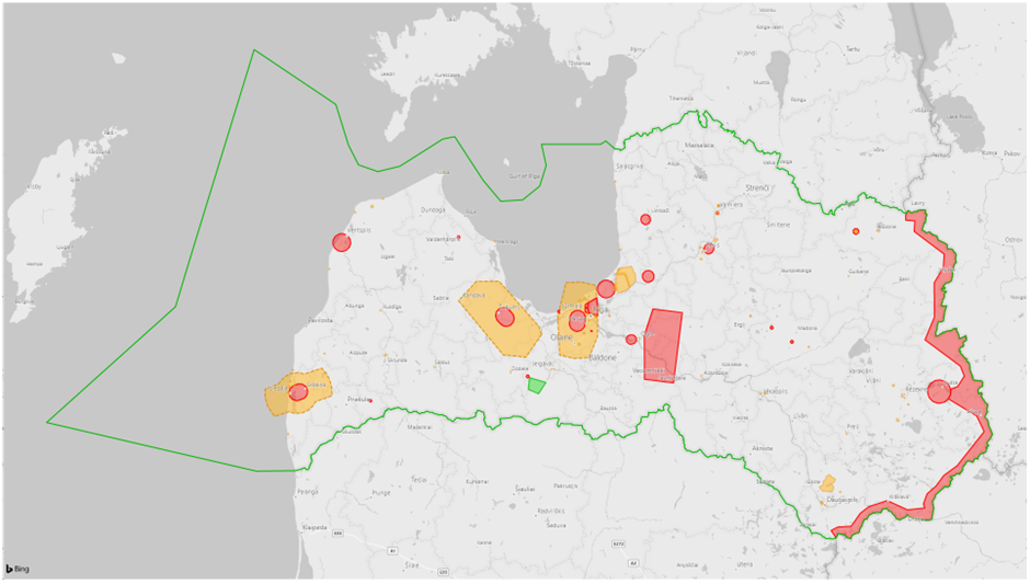
Figure 1 — Example of UAS geographical
zones
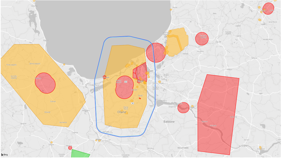
Figure 2 — Example of UAS geographical
including representation of planned U-space